Weather
Hazardous Weather Outlook Issued For N.J. Weekend Storms, Heat
A hazardous weather outlook was issued for a possibly stormy New Jersey weekend with a — gasp! — heat index of up to 115.

The New Jersey weekend looks like it could be sizzling hot, sticky and slick.
Heat index temperatures — taking humidity into account — could reach as high as 115 in New Jersey as the state also deals with heavy rains, flooding and scattered thunderstorms, according to the National Weather Service.
The heat index considers what the heat really feels like since humidity is supposed to reach upwards of 60 and 70 percent this weekend.
Find out what's happening in Brickfor free with the latest updates from Patch.
A hazardous weather outlook has been issued for the whole state because of the storm threat, and an excessive heat warning also has been issued since the heat index is supposed to hit 105 to 110 on Friday and Sunday and 110 to 115 on Sunday.
The highest temperature ever recorded anywhere in New Jersey was 110 degrees in Old Bridge in 1936. That DID NOT include humidity and the heat index. That was the actual temperature.
Find out what's happening in Brickfor free with the latest updates from Patch.
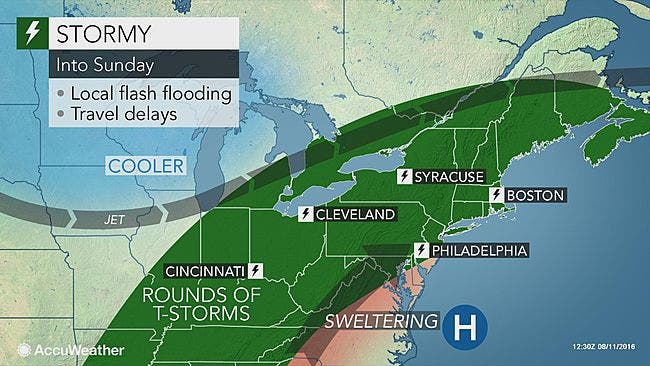
Here is the AccuWeather outlook on the weekend:
Here is the National Weather Service forecast for the weekend:
Friday: Isolated showers and thunderstorms after 3 p,m. Partly sunny, with a high near 93. Heat index values as high as 110. West wind 9 to 11 mph. Chance of precipitation is 20 percent.
Friday night: Scattered showers and thunderstorms, mainly before 11 p.m. Some of the storms could produce heavy rain. Mostly cloudy, with a low around 73. Southwest wind around 6 mph becoming calm. Chance of precipitation is 40 percent. New rainfall amounts between a tenth and quarter of an inch, except higher amounts possible in thunderstorms.
Saturday: A chance of showers and thunderstorms, mainly after noon. Partly sunny, with a high near 94. Heat index values as high as 115. Southwest wind 3 to 8 mph. Chance of precipitation is 40 percent. New rainfall amounts between a tenth and quarter of an inch, except higher amounts possible in thunderstorms.
Saturday night: A chance of showers and thunderstorms. Mostly cloudy, with a low around 75. Light southwest wind. Chance of precipitation is 40 percent. New rainfall amounts of less than a 10th of an inch, except higher amounts possible in thunderstorms.
Sunday: A chance of showers and thunderstorms. Partly sunny, with a high near 94. Calm wind becoming west 5 to 9 mph in the morning. Chance of precipitation is 50 percent. New rainfall amounts between a tenth and quarter of an inch, except higher amounts possible in thunderstorms.
Sunday night: A chance of showers and thunderstorms. Mostly cloudy, with a low around 72. Chance of precipitation is 40 percent. New rainfall amounts between a tenth and quarter of an inch, except higher amounts possible in thunderstorms.
Get more local news delivered straight to your inbox. Sign up for free Patch newsletters and alerts.