Weather
NJ Weather: More Storms On The Way, Alerts Issued
A winter weather advisory and a hazardous weather outlook were actually issued in parts of NJ, two days after temperatures hit 80 degrees.



The 80-degree temperatures from two days ago are certainly a distant memory now that the nasty weather is expected to continue on Friday, and soak New Jersey through the weekend. Winter weather alerts have actually been issued in some parts of the state.
The National Weather Service issued a winter weather advisory for Sussex County because of freezing rain on Friday. Much of North Jersey received a hazardous weather outlook because of rain and potential flooding connected to what The Weather Channel is calling "Winter Storm Oliver."

The National Weather Service says total ice accumulations of less than a 10th of an inch are expected in Sussex County. The winter weather advisory is in effect until 1 p.m. Friday. Untreated roads, walkways and parking lots may become ice covered and slippery.
Find out what's happening in Brickfor free with the latest updates from Patch.
Father south, rain will continue off and on into this afternoon near and just south of I-80, and temperatures may still be around freezing in a few locations. So be alert for a few icy spots, especially in northern Morris County.
Throughout New Jersey, heavy rainfall could cause local rivers and creeks to rise through the weekend and into early next week, and there could be the potential for poor drainage and low lying flooding Sunday, according to the National Weather Service.
Find out what's happening in Brickfor free with the latest updates from Patch.
The worst of the rain is expected to come on Saturday night.
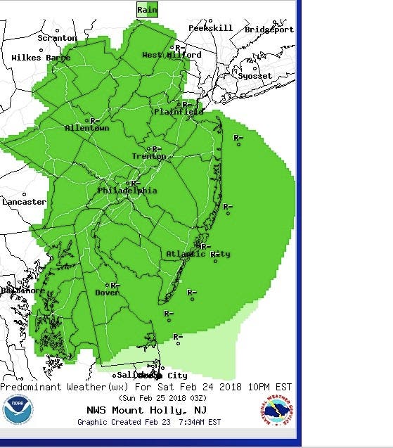
Here is the forecast:
- Friday: Rain (freezing rain Morris and north). High near 47. East wind 6 to 10 mph. Chance of precipitation is 90%. New precipitation amounts between a tenth and quarter of an inch possible.
- Friday night: A chance of rain, mainly before midnight. Patchy fog. Otherwise, cloudy, with a low around 43. Southeast wind 5 to 7 mph becoming west after midnight. Chance of precipitation is 30%. New precipitation amounts of less than a tenth of an inch possible.
- Saturday: A chance of rain, mainly after 1pm. Cloudy, with a high near 58. Light and variable wind becoming northwest around 5 mph in the afternoon. Chance of precipitation is 50%. New precipitation amounts of less than a tenth of an inch possible.
- Saturday night: Rain. Low around 44. East wind 8 to 11 mph. Chance of precipitation is 90%. New precipitation amounts between a quarter and half of an inch possible.
- Sunday: Rain. High near 60. East wind 9 to 11 mph becoming south in the afternoon. Chance of precipitation is 90%. New precipitation amounts between a quarter and half of an inch possible.
- Sunday night: A slight chance of showers before 1am. Mostly cloudy, with a low around 45. Chance of precipitation is 20%
Cloud photo via Shutterstock
Get more local news delivered straight to your inbox. Sign up for free Patch newsletters and alerts.