Weather
UPDATE: Tropical Storm Impact On N.J. 'Getting More Serious Now,' Forecasters Say
The tropical storm warning is now in effect in New Jersey as Hermine's potential impact on the state has expanded to several more counties.

A tropical storm warning is now in effect in New Jersey as Hermine's potential impact on the state expanded Friday to several more counties, and it potential impact is "getting more serious," forecasters say.
Forecasters are now saying that parts of the state will have dangerously high amounts of flooding that could be the worst since Superstorm Sandy - or even worse.
Read more: Hour-By-Hour Forecast Of Tropical Storm Hermine In New Jersey
Find out what's happening in Brickfor free with the latest updates from Patch.
Sam DeAlba, a meteorologist at WeatherWorks in Hackettstown, told nj.com that areas that saw flooding during Sandy are likely to see flooding again and "we're preparing our clients for potentially four feet or more of storm surge."
Lance Franck, a meteorologist at the National Weather Service's regional forecast office in Mount Holly, also told the publication that the storm could stall and strengthen back into a hurricane once it gets to the New Jersey area "given it's over the warm water."
Find out what's happening in Brickfor free with the latest updates from Patch.
.A tropical storm warning is now in effect for seven New Jersey counties: Monmouth, Ocean, eastern Burlington, Atlantic, Cape May, Cumberland and Salem, according to the National Weather Service.
A tropical storm watch is in effect for Essex, Hudson, Middlesex counties according to the National Weather Service. A hazardous weather outlook has been issued for the rest of the state as winds moving at a speed of 30 mph or more were expected to impact New Jersey.
Here was the location of the storm at 7 a.m.:
- About 220 south-southwest of Ocean City, Md.
- Storm intensity: 60 mph
Forecasters gave a glimpse of what New Jersey residents should expect:
Getting more serious now. @NWS_MountHolly forecast for just off Atlantic City NJ. Gusts near 60 mph & seas to 23' pic.twitter.com/Li5jOIopEP
— Gary Szatkowski (@GarySzatkowski) September 3, 2016
So, how about the 18Z GFS? Does it take #Hermine harmlessly out to sea? Nope. Map valid 200 AM Monday. pic.twitter.com/aEZDxT3Moh
— Gary Szatkowski (@GarySzatkowski) September 3, 2016
Here is the warning issued by the NWS:
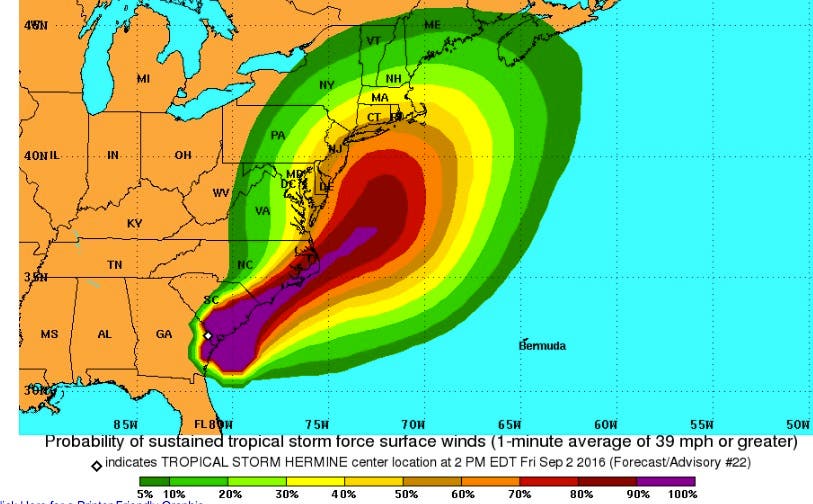
Late Friday, Tropical Storm Hermine was centered over southeast Georgia, and was expected to move northeastward into the Carolinas on Saturday and off the Mid-Atlantic coast Saturday night.
The storm is then expected to slow down or stall off the Delaware and New Jersey coasts Sunday and Monday before gradually moving away from the area during the middle of next week.
The following impacts are likely to occur:
- Sustained tropical-storm-force winds are possible over immediate coastal areas including coastal waters and toward the lower Delaware Bay. Some tropical storm force gusts are possible farther inland.
- Hazardous seas and dangerously rough surf can be expected through the holiday weekend and possibly into the middle of next week.
- A moderate to high rip current risk can be expected at the beaches during this time. Minor to moderate coastal flooding is possible around the times of high tide from late Saturday onward.
- Prepare for locally hazardous surge having possible limited impacts across coastal locations or areas prone to tidal flooding, including the back bays. potential impacts in this area.
- Moderate beach erosion is expected. Heavy surf will also breach dunes, mainly in usually vulnerable locations.
- Strong rip currents are anticipated. Minor to locally moderate damage to marinas, docks, boardwalks, and piers is possible. A few small craft may be broken away from moorings.
- Prepare for dangerous wind having possible significant impacts across New Jersey and southeastern Pennsylvania and northeast Maryland.
- Some damage to roofing and siding is likely, along with damage to porches, awnings, carports, and sheds.
- A few buildings will experience window, door, and garage door failures. Mobile homes may be damaged, especially if unanchored.
- Several large trees may be snapped or uprooted. several fences and roadway signs could be blown over.
- Some roads may be impassable from large debris. A few bridges, causeways, and access routes may be impassable.
- There could be scattered power and communications outages, but they will be more prevalent in areas with above ground lines.
- Flooding rain: Prepare for locally hazardous rainfall flooding having possible limited impacts across the coastal plain.
- Evacuations: Now is the time to check your emergency plan and take necessary actions to secure your home or business. deliberate efforts should be underway to protect life and property. ensure that your emergency supplies kit is stocked and ready.
Photos: NWS
Get more local news delivered straight to your inbox. Sign up for free Patch newsletters and alerts.