Crime & Safety
WEATHER UPDATE: How Much It Will Snow, and How Long
Snowfall predictions in New Jersey, along with forecasts of some of the coldest weather since 2004.

Cupid’s arrow will be covered in snow during a Valentine’s Day winter storm that is falling on New Jersey, with snow followed by frigid temperatures and tropical-storm-force winds..
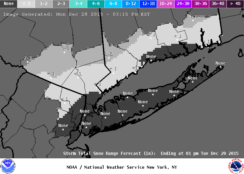
The latest snowfall projections from the National Weather Service call for 4-6 inches of snow accumulations across North Jersey Saturday afternoon through Sunday morning. Central Jersey is line for 3-4 inches of snow, while 1-3 inches could fall across South Jersey and the Jersey Shore
A Winter Weather Advisory is in effect until 1 p.m. Sunday, with periods of snow lasting until the morning. Hazardous travel conditions are expected. A High Wind Warning will be in effect from 10 p.m. Saturday until 2 pm. Sunday, with wind gusts expected to be as fast as 60 mph. A Wind Chill Advisory is in effect from 4 p.m. Sunday until 11 a.m. Monday.
Find out what's happening in Chathamfor free with the latest updates from Patch.
Here is what’s expected across much of the state on Saturday and Sunday:
Find out what's happening in Chathamfor free with the latest updates from Patch.
Here is what is expected in Bergen, Passaic and Hudson counties:
Light snow is expected to continue Saturday. Considerable blowing and drifting snow with near-blizzard conditions is possible Saturday night in northwestern New Jersey into Sunday morning as winds increase.
The snow will taper off Sunday afternoon, with bitter cold left in its wake. The high on Sunday will only reach the mid-teens, with wind chill temperatures dropping to 5 to 11 below zero. The mercury will dip to near zero on Sunday night and blustery winds could make it feel like 20 below.
Get more local news delivered straight to your inbox. Sign up for free Patch newsletters and alerts.