Weather
Outages, Downed Trees, 'Nearly Impossible' Travel: Cherry Hill Braces For Winter Storm
Weather officials reduced their snowfall predictions, but the ice could be especially potent in South Jersey.

CHERRY HILL, NJ — Weather officials lowered their projections Friday afternoon for this weekend's winter storm. But the ice could be especially potent throughout the region, especially for South Jersey towns like Cherry Hill, according to the National Weather Service (NWS).
Snow will begin after midnight late Saturday night into early Sunday morning. The storm will peak sometime during the day Sunday and into the evening before winding down into Monday morning, says the NWS's regional office in Mount Holly.
A winter storm warning is in effect for the entire region from 7 p.m. Saturday to 1 p.m. Monday for the entire region. During that time:
Find out what's happening in Cherry Hillfor free with the latest updates from Patch.
- Heavy snow and mixed precipitation are expected.
- Power outages and tree damage from ice are likely.
- Travel could become "nearly impossible," the NWS's warning says.
- Hazardous travel conditions could linger into the Monday morning commute.
Roughly 8 to 12 inches of snow are expected throughout South Jersey — down from the NWS's projections of 12 to 18 inches from Friday morning.
"Snowfall amounts have trended down slightly, but ice amounts have trended up slightly for some areas," NWS Mount Holly said. "Regardless of exactly how much snow falls, our message is the same: Significant impacts are expected for our entire area!"
Find out what's happening in Cherry Hillfor free with the latest updates from Patch.
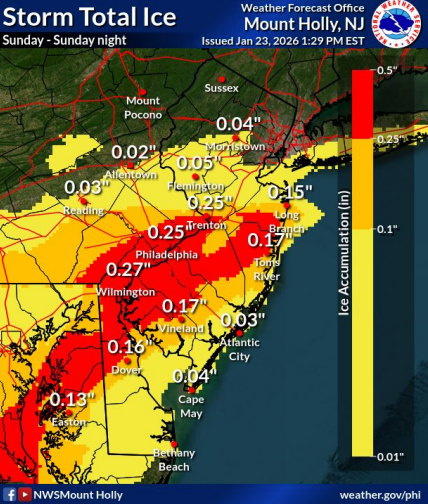
The threat of ice accumulation looms especially large in South Jersey, where up to 0.3 inches could accumulate Sunday.
"The combination of heavy snow followed by sleet/freezing rain and breezy northeast winds gusting 20-30 mph could result in some isolated instances of downed trees and power lines, and power outages," NWS Mount Holly said in a Friday afternoon storm briefing.
Meanwhile, an extremely cold period will run from Friday night through next week, according to forecasters.
A cold weather advisory is in effect from midnight to 10 a.m. Saturday, when wind chills could dip to 7 below zero.
"Frostbite and hypothermia will occur if unprotected skin is exposed to these temperatures," the advisory says. "Wind chill values can lead to hypothermia with prolonged exposure."
Click here for the National Weather Service's latest winter storm briefing as of Friday. An updated briefing will be released around 7 a.m. Saturday.
Will Schools Be Open On Monday?
The Cherry Hill School District hasn't made that determination as of this writing.
"Should weather conditions require a change to the school schedule, the district will communicate decisions as quickly and clearly as possible," said Superintendent Dr. Kwame R. Morton, Sr.
When a decision is made, notifications will be sent in the following ways, Morton says:
- via phone calls and emails to contact information listed in the Genesis Parent Portal.
- on the district website's homepage.
- on the district's Facebook and Instagram pages.
Local Guidance
Cherry Hill police have urged residents to make storm preparations.
"Residents are encouraged to prepare now by securing their homes, clearing walkways, and planning ahead for travel," the police department said. "If you must be on the road, please slow down, allow extra stopping distance, and remain alert."
Meanwhile, township officials are coordinating closely with first responders, the Office of Emergency Management, and Public Works personnel.
Here are a few reminders from the township:
- Do not park cars on the street from an hour after the snow has continuously fallen until 12 hours after the snow has stopped.
- When clearing snow, shovel or blow it onto your lawn or the curb — not onto the street or sidewalk.
- Fill your car with gas, charge your devices, and stock up on potable water and non-perishable food.
- Check up on your most vulnerable neighbors and make sure they have needed supplies and medications.
- Bring your pets inside.
Click here for Cherry Hill's snow-removal guidelines.
Here's the National Weather Service's forecast for Cherry Hill as of this writing:
- Saturday: Partly sunny, with a high near 20. Wind chill values as low as -7. North wind 5 to 15 mph.
- Saturday night: Snow after 1 a.m. Low around 14. Calm wind becoming northeast around 5 mph after midnight. Chance of precipitation is 90 percent. New snow accumulation of 1 to 2 inches possible.
- Sunday: Snow before 1 p.m., then snow, freezing rain, and sleet. The snow could be heavy at times. High near 29. Northeast wind 10 to 15 mph, with gusts as high as 30 mph. Chance of precipitation is 100 percent. New ice accumulation of 0.1 to 0.2 of an inch possible. New snow and sleet accumulation of 6 to 10 inches possible.
- Sunday night: Snow and sleet before 10pm, then freezing rain and sleet between 10 p.m. and 4 a.m., then snow likely after 4 a.m. Low around 23. Northeast wind 10 to 15 mph, with gusts as high as 30 mph. Chance of precipitation is 100 percent. New ice accumulation of 0.1 to 0.2 of an inch possible. New snow and sleet accumulation of 1 to 2 inches possible.
- Monday: Snow likely, mainly before 7 a.m. Partly sunny, with a high near 29. Chance of precipitation is 60 percent.
- Monday night: Partly cloudy, with a low around 7.
Get more local news delivered straight to your inbox. Sign up for free Patch newsletters and alerts.