Politics & Government
Flood-Impacted Residents Should Evacuate Before Storm, BurlCo Officials Say
The county declared a state of emergency ahead of Friday night's storm. The NWS expects 'major' coastal flooding along the Delaware River.


BURLINGTON COUNTY, NJ — A state of emergency was issued Friday in Burlington County ahead of a rainstorm that could cause additional flooding.
The Burlington County Office of Emergency Management, which declared the county-wide emergency, encourages residents affected by flooding to voluntarily evacuate if they were impacted by flooding from Tuesday night's storm.
A temporary shelter from the American Red Cross will remain open Friday at the Delran Firehouse (9 South Bridgeboro St., Delran). The county will open a second, larger shelter if necessary.
Find out what's happening in Cinnaminsonfor free with the latest updates from Patch.
"We're bracing for more rain, strong winds and potential for more severe flooding," said County Commissioner Deputy Director Dan O'Connell. "Our emergency management teams and first responders are making preparations, but in the interest of everyone’s safety, we're asking residents in our previous flood zones to voluntarily evacuate in order to avoid putting lives at risk."
Residents with questions about whether to evacuate should contact their local emergency-management coordinator. For emergencies, call 911.
Find out what's happening in Cinnaminsonfor free with the latest updates from Patch.
County residents can sign up for emergency alerts and notifications from the Burlington County Department of Public Safety.
The National Weather Service (NWS) expects 0.5 to 1.5 inches of rain in the region, along with 40-50 mph gusts Friday night into Saturday. "Major" flooding is expected in the county along the Delaware River.
"The current forecast supports similar flood impacts to those experienced Tuesday night and Wednesday," said the NWS's Philadelphia/Mount Holly office. "This includes potential for extensive inundation of roads and structures. If you live near these areas, prepare now for severe coastal flooding."
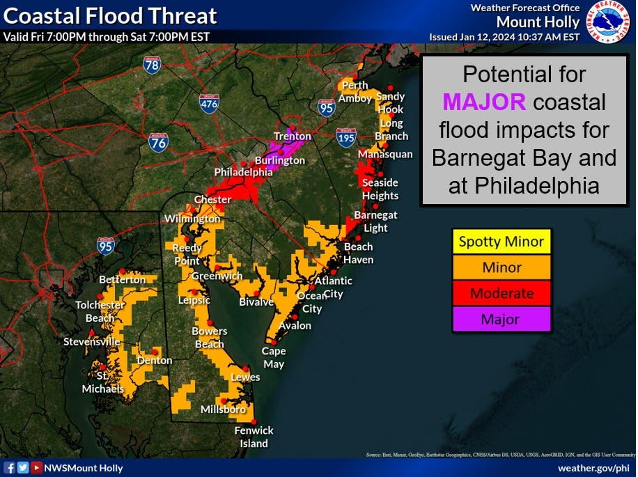
Rain will push in late Friday evening, becoming heaviest around 11 p.m. to 4 a.m., the NWS said. The rain will taper off by Saturday's sunrise.
Saturday's high tides will occur around 3:30 a.m. and 3:45 p.m.
Normally, this type of storm would induce minor flooding at most, the NWS said. But because of Tuesday night's rainfall, soils are still saturated while many rivers remain at elevated levels.
Flooding from the storm prompted Cinnaminson officials to make an emergency proclamation on Wednesday.
Read more:
- Flood Recovery Continues In Cinnaminson, With Another Storm Expected
- Emergency Proclamation Issued In Cinnaminson During Storm Aftermath
Here's the NWS's latest forecast for northwestern Burlington County:
- Friday night: Rain with a slight chance of thunderstorms. Rain may be heavy at times. Windy and not as cool with lows in the mid-40s. Temperature rising into the mid-50s after midnight. Southeast winds 20 to 25 mph with gusts up to 40 mph, becoming south 20 to 30 mph with gusts up to 50 mph after midnight. Chance of rain near 100 percent.
- Saturday: Mostly sunny. A chance of rain in the morning. Breezy with highs in the mid-50s. Temperature falling into the lower 40s in the afternoon. Southwest winds 15 to 25 mph with gusts up to 45 mph. Chance of rain 30 percent.
- Saturday night: Mostly clear. Colder with lows in the lower 30s. Southwest winds 15 to 20 mph. Gusts up to 35 mph in the evening.
- Sunday: Mostly sunny and breezy, cooler with highs in the lower 40s. Temperature falling into the mid-30s in the afternoon. Southwest winds 15 to 25 mph with gusts up to 35 mph.
Get more local news delivered straight to your inbox. Sign up for free Patch newsletters and alerts.