Weather
New Jersey Temperatures, Heat Index: Town-By-Town - 8/28/18
The heat index hit 111 degrees in at least one part of New Jersey on Tuesday. More of the same is expected on Wednesday. See list below.


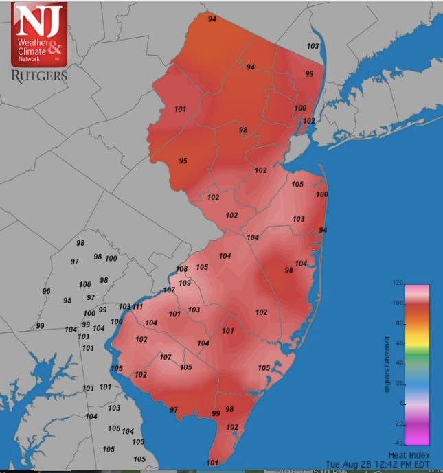
New Jersey once again experienced perhaps its worst heat of the year on Tuesday as the heat index hit 111 degrees. Many other areas also exceeded 100-degree-plus indexes. More of the same was expected on Wednesday.
Parts of Gloucester reached a 111-degree heat index on Tuesday, and we have the locations. Parts of many other counties were pushing toward the 110-degree mark, too.
Much of the same bad weather is supposed to continue on Wednesday. We are closely monitoring the heat as the state deals with possibly record-level temperatures across New Jersey. Read more: NJ Weather: 100-Plus Heat Index As Weather About To Get Worse
Find out what's happening in Cinnaminsonfor free with the latest updates from Patch.
Below are the town-by-town list of temperatures across New Jersey on Tuesday, and below that is a map that shows the heat indexes in the towns (we will update):
- Atlantic City Marina 86
- Basking Ridge 90
- Berkeley Twp. 93
- Bivalve 84
- Cape May Court House 94
- Cedar Bridge 93
- Charlotteburg 89
- Cherry Hill 95
- Columbus 93
- Cream Ridge 92
- Dennis Twp. 90
- Egg Harbor Twp. 94
- Fortescue 84
- Greenwich 93
- Hackettstown 90
- Hamilton 95
- Hammonton 93
- Harvey Cedars 86
- Haworth 94
- Hawthorne 95
- High Point 89
- High Point Monument 86
- Hillsborough 95
- Holmdel 93
- Hopewell Twp. 92
- Howell 94
- Jersey City 95
- Kingwood 90
- Logan Twp. 92
- Lower Alloways Creek Twp. 94
- Lyndhurst 93
- Mannington Twp. 91
- Moorestown 93
- Mullica Twp. 92
- New Brunswick 94
- Oceanport 94
- Oswego Lake 95
- Parsippany 89
- Pennsauken 95
- Pequest 92
- Piney Hollow 93
- Pittstown 89
- Point Pleasant 94
- Ramsey 90
- Red Lion 95
- Sea Girt 90
- Seaside Heights 91
- Sewell 93
- Sicklerville 95
- Silas Little 93
- South Harrison 92
- Stewartsville 92
- Toms River 95
- Upper Deerfield 92
- Vineland 94
- Wall Twp. 92
- Walpack 93
- Wantage 89
- West Cape May 89
- West Creek 93
- West Deptford 93
- Woodbine 92
- Woodstown 91
Here is the map showing heat indexes:
Find out what's happening in Cinnaminsonfor free with the latest updates from Patch.
Here is the forecast:
- Tuesday afternoon Mostly sunny, with a high near 94. Heat index values as high as 105. Southwest wind around 8 mph.
- Tuesday night: Mostly clear, with a low around 75. Southwest wind around 6 mph.
- Wednesday: Sunny, with a high near 95. Heat index values as high as 101. Southwest wind 6 to 10 mph.
- Wednesday night: Partly cloudy, with a low around 74. Southwest wind around 7 mph.
- Thursday: A chance of showers and thunderstorms, mainly after 2pm. Mostly sunny, with a high near 89. West wind 5 to 7 mph. Chance of precipitation is 30%. New rainfall amounts of less than a tenth of an inch, except higher amounts possible in thunderstorms.
Image via Shutterstock
Get more local news delivered straight to your inbox. Sign up for free Patch newsletters and alerts.