Neighbor News
Coastal low produces cool, unsettled conditions
A coastal low will produce cool and unsettled conditions to start the week
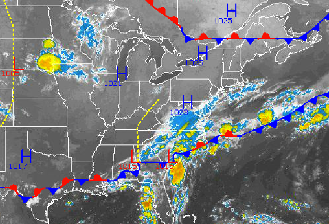
There is no greater indicator for a meteorologist that a Fall weather pattern to taking hold over the Eastern United States than the potential development of a coastal low pressure system over the coastal waters. These low pressure systems develop due to a thermal contrast from the coastal plain to the coastal waters that at times can be rather tricky to forecast for.
In this case, the coastal low pressure system is expected to be rather disorganized and just far enough off the coast of New Jersey to only produce periods of showers along the immediate coast, however clearly raw, cool, and at times wet weather conditions will set in over the northern Mid Atlantic through tomorrow.
Today through tomorrow, the area of low pressure along the Southeast coast will organize and lift northeast towards the New Jersey coastal waters. Clouds will increase through the day with showers developing in the afternoon. Showers will be isolated to widely scattered to the west of the Delaware River and over the northern interior. However, along and to the east of the Delaware River including all coastal locations, showers will be scattered to at times widespread. The showers will be capable of brief heavy downpours through tomorrow as bands of showers rotate in from the Atlantic Ocean. Rainfall amounts through tomorrow will range from up to a tenth of an inch over the interior to a quarter to a half inch of rain along the coast with locally higher amounts. Winds will be from the northeast at 5 to 15 mph over the interior and 10 to 20 mph with gusts up to 35 mph along the coast. Temperatures this afternoon will range from the mid to upper 70’s over the New York City metropolitan area and upper 70’s to lower 80’s over the Philadelphia metropolitan area. Temperatures tomorrow morning will vary significantly depending on cloud cover with upper 40’s to lower 50’s over the far northern interior, mid to upper 50’s over the western and northwestern suburbs of Philadelphia and New York City, and lower to mid 60’s in urban areas and along the coast. High temperatures tomorrow will range from the lower to mid 70’s over Long Island, mid to upper 70’s over the New York City metropolitan area, and upper 70’s to lower 80’s over the Philadelphia metropolitan area.
Find out what's happening in Freeholdfor free with the latest updates from Patch.
As the coastal low departs, scattered to broken cloud cover is expected on Wednesday with a few isolated to widely scattered showers possible. Winds will vary through the day from the north to eventually the southwest by the evening hours at 5 to 15 mph. Temperatures will range from the upper 50’s to lower 60’s for lows and mid to upper 70’s for highs throughout the northern Mid Atlantic.
A strong cold front will approach on Thursday with periods of showers and thunderstorms in the late afternoon and evening. The thunderstorms will be capable of very heavy downpours, frequent lightning, and wind gusts over 40 mph. Ahead of the cold front, a strong southwesterly wind at all levels of the atmosphere will transport a warm and humid air mass into the Philadelphia and New York City metropolitan areas for a brief period of time. Low temperatures will range from the lower to mid 60’s over the interior and mid to upper 60’s along the coast. High temperatures will range from the lower to mid 80’s over the New York City metropolitan area and mid to upper 80’s over the Philadelphia metropolitan area.
Find out what's happening in Freeholdfor free with the latest updates from Patch.
The cold front is expected to clear the coast on Friday morning with clearing skies from northwest to southeast. As a new Polar air mass builds into the region, low temperatures will range from the lower to mid 50’s over the interior and upper 50’s to lower 60’s along the coast. High temperatures will only rise into the lower to mid 70’s throughout the northern Mid Atlantic.
Polar high pressure is expected to remain in place on Saturday and Sunday with cool and tranquil weather conditions. Low temperatures are expected to range from the mid to upper 40’s over the interior and lower to mid 50’s along the coast. High temperatures will range from the upper 60’s to lower 70’s over the interior and lower to mid 70’s along the coast. Temperatures will fall to below normal levels by next weekend.


