Neighbor News
Tropical air mass visits briefly tomorrow
Tranquil conditions today will give way to severe thunderstorms tomorrow. Cool and unsettled this weekend
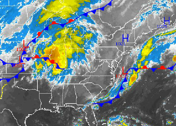
As an area of low pressure departs from the Mid Atlantic coastal waters and high pressure briefly builds in for this afternoon, tranquil conditions will take hold. However, a cold front over the Plains will rapidly drive towards the New York City and Philadelphia metropolitan areas by tomorrow afternoon and evening leading to showers and strong to severe thunderstorms. A cool and unsettled weather pattern will follow for the weekend and early next week.
Today, high pressure will gradually build into the Philadelphia and New York City metropolitan areas from northwest to southeast. An isolated shower is possible along the coast but not likely. Otherwise, scattered cloud cover is expected through this evening. Winds will back from the northeast to the northwest at 5 to 15 mph. Temperatures will rise into the mid 70’s in the New York City metropolitan area and mid to upper 70’s in the Philadelphia metropolitan area.
Tonight, the high pressure system will depart into the Atlantic Ocean with light and variable winds becoming southwesterly at 5 to 10 mph by morning. Scattered clouds are expected but areas of fog will be a threat. The fog may be locally dense. Temperatures will fall into the lower to mid 60’s for lows.
Find out what's happening in Freeholdfor free with the latest updates from Patch.
Tomorrow, the cold front will approach the region with showers and thunderstorms developing in the late afternoon and evening hours. The strongest thunderstorms will feature very heavy downpours, frequent lightning, wind gusts over 40 mph, and hail. The best potential for severe thunderstorms will be over eastern Pennsylvania and western New Jersey tomorrow afternoon into the early evening hours. Winds will be from the southwest at 5 to 15 mph. Temperatures will rise into the lower to mid 80’s over much of the Philadelphia and New York City metropolitan areas, upper 70s’ to lower 80’s along the immediate coast.
Polar high pressure will take hold on Friday with clear skies to scattered cloud cover. A much cooler air mass will be in place with very low humidity. Low temperatures will range from the lower to mid 50’s over the interior and upper 50’s to lower 60’s along the coast. High temperatures will range from the lower to mid 70’s throughout the northern Mid Atlantic.
Find out what's happening in Freeholdfor free with the latest updates from Patch.
A series of low pressure systems will move through the Philadelphia and New York City metropolitan areas Saturday on through Tuesday with a threat of scattered showers each day. While I do not expect widespread rainfall, conditions will remain unsettled through the forecast period with scattered to overcast cloud cover. Temperatures will feature near to below normal temperatures through the period. Low temperatures on Saturday will range from the mid to upper 40’s over the interior and lower to mid 50’s along the coast. Low temperatures for Sunday through Tuesday will range from the lower to mid 50’s over the interior and mid 50’s along the coast. High temperatures will range from the upper 60’s to lower 70’s over the interior and along the immediate coast and lower to mid 70’s throughout the rest of the Philadelphia and New York City metropolitan areas.


