Community Corner
Tropical and unsettled through tomorrow
Tropical conditions will be in place through tomorrow but will exit with heavy rain on Thursday.
A tropical air mass will be in place over the Philadelphia and New York City metropolitan areas through tomorrow which will lead to well above normal temperature, scattered to broken cloud cover, and a threat for a few isolated showers. Locally dense fog will be a concern as well. The tropical weather won’t last long though as a powerful cold front is expected to drive through the region on Thursday with very heavy rainfall.
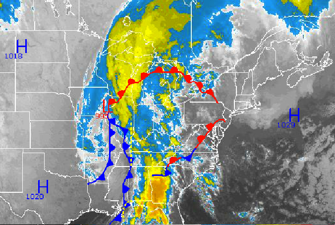
Today through tomorrow, high pressure off the New England coast will slowly drift to the east. The high pressure system will be strong enough to keep the steady rain building over the Tennessee River Valley from entering the region, however a few isolated showers will be a threat. Low clouds will be present through tomorrow with the potential for locally dense fog in the morning hours with visibility below 2 miles. Winds will be from the southeast at 5 to 15 mph. Temperatures this afternoon will rise into the mid 70’s for highs throughout the Philadelphia and New York City metropolitan areas. Temperatures tomorrow will range from the lower to mid 60’s for lows and mid 70’s for highs.
A strong, slow moving cold front will drive through the Philadelphia and New York City metropolitan areas tomorrow night through Thursday evening. Widespread showers will develop with heavy downpours expected. Within the rain shield, elevated thunderstorms will develop with an isolated one or two becoming severe. The strongest thunderstorms will feature occasional lightning, very heavy downpours, and wind gusts over 60 mph. The most significant threat on Thursday with this cold front will be high rainfall rates leading to localized flash flooding. In general, one to two inches of rain is expected with locally higher amounts in heavy downpours. Winds will veer from the southeast to west at 5 to 15 mph. Temperatures will range from the upper 50’s to lower 60’s for lows and lower to mid 70’s for highs.
Find out what's happening in Freeholdfor free with the latest updates from Patch.
A few isolated showers will linger on Friday morning with clearing skies by the afternoon expected. The cooler air will be slow to enter the region, as such, temperatures will remain above normal. Low temperatures will range from the upper 40’s to lower 50’s. High temperatures will range from the upper 60’s to lower 70’s.
High pressure will be in control Saturday on through Monday with clear skies to scattered cloud cover. Temperatures will return to near normal levels. Low temperatures will range from the upper 30’s to lower 40’s over the interior and mid to upper 40’s along the coast. High temperatures on Saturday will range from the upper 60’s to lower 70’s. High temperatures on Sunday and Monday will range from the upper 50’s to lower 60’s over the interior and lower to mid 60’s along the coast.


