Community Corner
Wet start to the weekend on the way
Cloudy conditions today will give way to moderate to heavy rain tomorrow morning. Very cool weather returns for Sunday
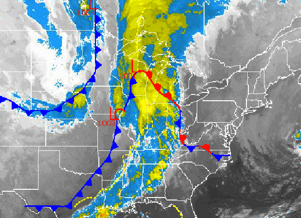
Tranquil yet cloudy conditions today will give way to rain by tomorrow morning as a cold front drives through the Philadelphia and New York City metropolitan areas. The rain will exit by tomorrow evening and will be followed by a very cool and windy air mass by Sunday morning. There is even a good potential for frost in the morning to start the week!
Today, high pressure will exit into the Atlantic Ocean with scattered to broken cloud cover through the day. Winds will veer from the northeast to southeast at 5 to 15 mph. Temperatures will rise into the upper 60’s to lower 70’s for highs this afternoon.
Tonight, overcast skies can be expected with rain developing around mid night over eastern Pennsylvania and spreading to the east through tomorrow morning. The rain will be heavy at times through tomorrow morning and early afternoon. The rain will exit the entire region between noon and 5 PM tomorrow. Rainfall amounts will range from 0.50” to 1.50” over the New York City metropolitan area and 0.25” to 0.75” over the Philadelphia metropolitan area. Winds will veer from the southeast to west at 10 to 20 mph with higher gusts at times. Low temperatures will range from the upper 50’s to lower 60’s. High temperatures will range from the mid to upper 60’s.
Find out what's happening in Freeholdfor free with the latest updates from Patch.
Canadian high pressure will build into the region tomorrow night with clearing skies and remain in place through Monday with clear skies to scattered cloud cover expected. Winds will be from the west at 10 to 20 mph, decreasing to 5 to 15 mph by Sunday night. Low temperatures will range from the mid to upper 30’s over the interior and lower to mid 40’s along the coast. High temperatures will range from the upper 50’s to lower 60’s on Sunday and mid to upper 60’s on Monday.
A series of low pressure systems will move through the region on Tuesday and Wednesday with widely scattered showers expected. The showers will be capable of heavy downpours at times. Temperatures will range from the lower to mid 50’s for lows and lower to mid 70’s for highs.
Find out what's happening in Freeholdfor free with the latest updates from Patch.
High pressure will produce clear skies to scattered clouds on Thursday and Friday. Temperatures will range from the upper 40’s to lower 50’s for lows and mid to upper 60’s for highs.


