Weather
Winter Weather Advisory For Snowy NJ Nor'easter In 15 Counties
UPDATE: The threat has increased now that NJ could get its first dose of snow, coming in the form of a nor'easter. Schools made changes.


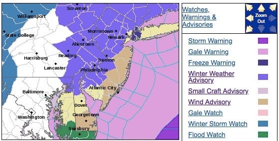
A winter weather advisory now has been issued in 15 counties for a New Jersey storm that could pack a punch on Thursday and Friday, arriving in the form of a nor'easter with 55-mph winds, according to the National Weather Service.
Patch has the hour-by-hour breakdown of the storm's impact on each region of New Jersey. Read more: Hour-By-Hour Forecast Of NJ Nor'easter Snow, Rain, 55-MPH Winds
Lee Robertson of the National Weather Service said the storm will arrive on the form of a nor'easter, packing strong winds and posing a flooding theat. The storm has already impacted school schedules. "It's going to be a pretty messy storm," he said.
Find out what's happening in Gloucester Townshipfor free with the latest updates from Patch.
Read more: New Jersey School Closings/Dismissal List For Thursday, Friday
Here is what is expected:
Find out what's happening in Gloucester Townshipfor free with the latest updates from Patch.
- A wintry mix develops over southeast Maryland and Delaware Thursday morning, then lifts into southeast Pennsylvania and southern New Jersey.
- The wintry mix could last several hours during the day on Thursday before gradually changing to rain during the afternoon. Rain may be heavy at times into Thursday evening.
- A wintry mix develops over the Lehigh Valley, southern Poconos, and northern New Jersey by Thursday afternoon and continues into Thursday evening. The wintry mix may last into Friday morning.
- Strong winds gusting to 45 to 55 mph will develop along the NJ shore and southern DE Thursday afternoon and will diminish Thursday night.
- Gale force winds are expected on the coastal waters Thursday through Friday.
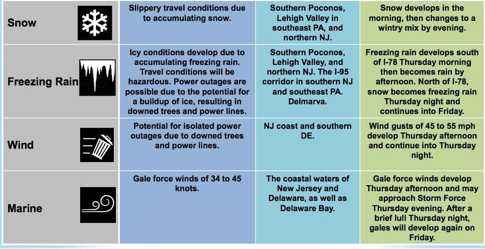
Mixed precipitation is expected, and total snow accumulations of 1 to 3 inches with ice accumulations are in the forecast for Salem, Gloucester, Camden, western Burlington, Mercer, Middlesex, Somerset, Hunterdon, Warren, Union, Essex, Bergen, Passaic, Morris and Sussex counties.
The winter weather advisory wil be in effect from 10 a.m. to 9 p.m. on Thursday. Plan on slippery road conditions. The hazardous conditions could impact the evening commute.
Indeed, the storm is a "potent mess" of rain, ice and snow that has even left accumulation as far south as Louisiana, The Weather Channel says. Much of Central Pennsylvania, where 3 to 6 inches is predicted, is under a Winter Storm Watch, the NWS said
The National Weather Service has issued a hazardous weather outlook across the rest of the state, saying the coastal storm will bring heavy precipitation and gusty winds to the region on Thursday into Friday.
A wintry mix of snow, sleet, and freezing rain is likely with snow and ice accumulation expected, particularly in North Jersey, according to the NWS. Localized flooding is also possible. Winds could range anywhere from 15 to 30 mph on Friday (see forecast below).

It would be rather early for accumulating snow in the region. In a typical season, the first snowfall in New Jersey happens around mid-December, according to The Weather Channel.
Snow fell during pre-Halloween nor'easter in 2011; wires and tree branches fell because of the wet snow, and many leaves hadn't fallen yet, adding weight to the power lines and trees.
Motorists and airline passengers in much of the eastern U.S. should be prepared for more delays as the winterlike storm for this week runs its course ahead of the surge in travel around Thanksgiving, according to AccuWeather.
-1542203560-4112.jpg)
The weather pattern will be more typical of late December or early January storm that will persist across much of the eastern U.S. this week. "The pattern not only features much colder-than-average conditions for the middle of November, but is also packed with winter-like storms," AccuWeather said in a news release.
While the bulk of the precipitation is expected to be rain and wintry mix, snow is possible at the onset of the storm, AccuWeather said.
How much snow ends up falling will ultimately depend on the storm track: a low-pressure system close to the coast or inland would draw warmer air from the Atlantic Ocean, leading to more rain than snow, according to The Weather Channel.
-1542203619-542.jpg)
An offshore track would allow cold air to remain locked in across the East, which means snow or an icy mix over a larger swath of the region.
"Since it may precipitate hard at the onset, when temperatures are near or below freezing in the I-95 zone from Washington, D.C. on up, there can be a quick accumulation that makes some roads slippery," AccuWeather Senior Meteorologist Bernie Rayno said.
Check back for updates as the storm nears.
-1542203641-7740.jpg)
Here is the forecast:
- Thursday: Snow and sleet, mainly after 1pm. High near 30. East wind 6 to 8 mph. Chance of precipitation is 90%. New snow and sleet accumulation of 1 to 3 inches possible.
- Thursday night: Snow, freezing rain, and sleet before 1am, then rain or freezing rain between 1am and 4am, then rain after 4am. Low around 30. Northeast wind 11 to 13 mph. Chance of precipitation is 100%. New ice accumulation of less than a 0.1 of an inch possible. New snow and sleet accumulation of around an inch possible.
- Friday: Rain and snow, becoming all rain after 11am. High near 43. North wind 9 to 14 mph becoming west in the afternoon. Chance of precipitation is 80%. New snow accumulation of less than a half inch possible.
Mark Doyle and Tom Davis photos
Get more local news delivered straight to your inbox. Sign up for free Patch newsletters and alerts.