Weather
NJ Weather: Severe Thunderstorm Watch Was In 11 Counties
A severe thunderstorm watch was in effect in 11 counties. Now a flood watch has been issued. Find out when.


A flood watch was in effect Thursday morning in many areas of New Jersey. Here are the alerted areas:

An area of heavy rain is forecast to lift northeastward across the region Thursday night. Rainfall totals up to an inch or two are expected with some locally higher amounts possible.
The heaviest of the rain is expected to fall over only a few hours. As a result, localized flooding is anticipated on roadways and in areas of poor drainage. Small streams and creeks are already running high and some minor flooding may occur, according to the National Weather Service.
Find out what's happening in Hillsboroughfor free with the latest updates from Patch.
A severe thunderstorm watch was in effect in 11 New Jersey counties on Wednesday evening, according to the National Weather Service. A hazardous weather outlook was in effect throughout the rest of the state.
These counties were subject to the severe thunderstorm watch, which was in effect until 11 p.m.
Find out what's happening in Hillsboroughfor free with the latest updates from Patch.
- BURLINGTON
- CAMDEN
- CUMBERLAND
- GLOUCESTER
- HUNTERDON
- MERCER
- MORRIS
- SALEM
- SOMERSET
- SUSSEX
- WARREN
The chances of severe storms hitting New Jersey on Wednesday increased one day after heavy rains and flooding besieged the state, according to the National Weather Service.
There was a "three-in-five chance" that storms packing winds up to 50 mph will hit much of New Jersey late Wednesday, according to Trent Davis, an NWS meteorologist. Flooding could become a bigger risk since as many as 4 inches of rain fell on Tuesday (see rain totals below).
The National Weather Service has even labeled the storms as severe, painting New Jersey in a sea of red around 8 p.m.:

Some of the storms could be severe with damaging winds, according to the National Weather Service. In addition, some storms through this period will be capable of producing heavy rain leading to localized flooding primarily in poor drainage areas.
Davis said the worst of the storms will arrive after 8 p.m.

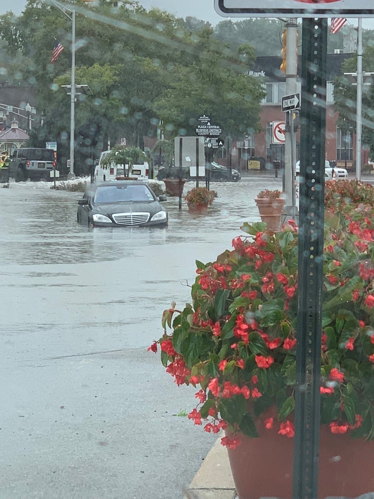
Flooding continued, meanwhile, in the Princeton area one day after roads were closed and a number of rescues were made on New Jersey streets, particularly in Hudson and Bergen counties.
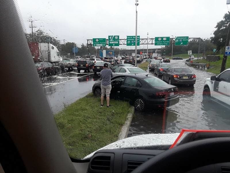
The New Jersey Turnpike and Route 495 also were inundated with flooding on Tuesday:
Here is how flooding impacted a number of areas:
Dramatic Photos Of Secaucus Flooding Tuesday
Dramatic photos show just how bad the flooding was today throughout low-lying Secaucus. Several people had to be rescued from their cars on Meadowlands Parkway and Secaucus Road, police told Patch. Many roads, including those two, are shut down as the flood waters now recede throughout town. Read more here...
Part Of Rt. 4 Closed Due To Downed Tree
Part of Route 4 West was closed due to a downed tree. Route 4 West between Myrtle Avenue and Jones Road is shut down because a tree fell across all traffic lanes, borough officials said. Read more here...
Rescues On Streets In Bergen, Elsewhere As Flooding Besieges Area
First responders braved floodwaters Tuesday to rescue people from floodwaters that flowed through towns in Bergen County and elsewhere in New Jersey. Read more here...
-1537967753-3671.jpg)
Flooding found elsewhere:
Trenton
Trenton flash flooding #nj #weather #rain https://t.co/4QRkGhIVDn pic.twitter.com/JooYG86j3L
— Bumper DeJesus (@bumperdejesus) September 25, 2018
Fairfield
FLASH FLOODING in #EssexCounty #Fairfield NJ...Greenbrook creek overflowing into the parking lot at my job for the second time in a month pic.twitter.com/9MhMIoQWU0
— ✨Sheryle✨ (@Sheryle1122) September 25, 2018
Burlington Township
...a few more of the street flooding in Burlington Township @NWS_MountHolly #NJwx pic.twitter.com/IZe1VmczBZ
— Burlington NJ Wx (@BurlingtonNJWx) September 25, 2018
Here are the rainfall totals:
- Woodbury 4.53
- Lyndhurst 3.82
- Haworth 3.78
- Mantua Twp 3.5
- Woodbury Heigh 3.31
- West Deptford 3.03
- Hawthorne 2.83
- Woodbine 2.64
- Ramsey 2.52
- Walpack 2.41
- Deptford 2.4
- Wayne 2.3
- Holmdel 2.22
- Mansfield 2.2
- Hamilton 2.18
- Parsippany 2.16
- Pequest 2.09
- Hopewell Twp. 2.02
- Moorestown 1.9
- High Point Monument 1.89
- Cream Ridge 1.88
- Columbus 1.83
- Basking Ridge 1.79
- New Brunswick 1.78
- Charlotteburg 1.68
- Jersey City 1.56
- Stewartsville 1.55
- Wall Twp. 1.53
- Hillsborough 1.47
- Howell 1.39
- Pittstown 1.36
- Pennsauken 1.3
- Kingwood 1.14
- Hackettstown 1.11
- West Deptford 1.11
- Oceanport 0.95
- Red Lion 0.86
- Silas Little 0.84
- Cherry Hill 0.79
- Sea Girt 0.74
- Logan Twp. 0.52
- Toms River 0.52
- Point Pleasant 0.51
- Sicklerville 0.5
- Cedar Bridge 0.49
- Berkeley Twp. 0.46
- Greenwich 0.43
- Vineland 0.38
- Piney Hollow 0.37
- West Creek 0.33
- Seaside Heights 0.32
- Harvey Cedars 0.27
- Lower Alloways Creek Twp. 0.25
- Egg Harbor Twp. 0.23
- Oswego Lake 0.23
- Sewell 0.23
- Hammonton 0.18
- Mannington Twp. 0.18
- South Harrison 0.15
- Upper Deerfield 0.15
- Mullica Twp. 0.11
- Woodstown 0.11
- Atlantic City Marina 0.06
- Dennis Twp. 0.03
- Woodbine 0.03
- Cape May Court House 0.01
Here is the forecast:
- Wednesday night: Showers and thunderstorms likely, mainly before 11pm. Some storms could be severe, with damaging winds and heavy rain. Cloudy, with a low around 60. North wind around 9 mph. Chance of precipitation is 70%. New rainfall amounts between a tenth and quarter of an inch, except higher amounts possible in thunderstorms.
- Thursday: A slight chance of rain after 2pm. Mostly cloudy, with a high near 67. North wind around 8 mph. Chance of precipitation is 20%.
- Thursday night: A chance of rain, then rain likely and possibly a thunderstorm after midnight. Some of the storms could produce heavy rainfall. Cloudy, with a low around 59. East wind 5 to 7 mph. Chance of precipitation is 60%. New rainfall amounts between a quarter and half of an inch possible.
- Friday: A chance of rain. Cloudy, with a high near 70. East wind around 6 mph. Chance of precipitation is 40%. New precipitation amounts between a tenth and quarter of an inch possible.
Photos of New Jersey Turnpike and Route 495 area flooding courtesy of Freddy @FreddyJ_23
Get more local news delivered straight to your inbox. Sign up for free Patch newsletters and alerts.