Weather
Hoboken Revises Driving Ban During Tropical Storm Isaias (UPDATE)
"If the storm is greater than a 50-year flooding event, the majority of streets in Hoboken ... could flood," says the OEM.

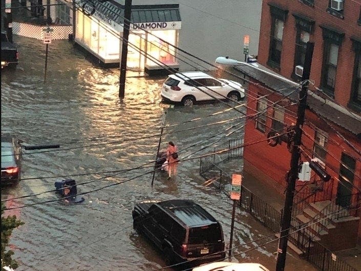

HOBOKEN, NJ — The mayor and Office of Emergency Management coordinator in Hoboken said on Monday that they are prohibiting driving in the mile-square city from 5 p.m. Tuesday to 5 a.m. Wednesday, as Tropical Storm Isaias approaches. Two storms in July, including Tropical Storm Fay, resulted in flash floods that stranded cars in the low-lying city (see photos).
Previously, they had restricted driving for all of Tuesday, but revised the hours Monday afternoon. However, they said they still "strongly advise" people to stay off the roads on Tuesday.
"Given the potential for heavy flooding and power outages due to heavy winds," the city warned on Sunday, "residents should take the precautions of obtaining enough water and food, including non-perishable goods, for at least 72 hours. Residents should also have flashlights and batteries available."
Find out what's happening in Hobokenfor free with the latest updates from Patch.
The tide in the Hoboken waterfront area on Tuesday is supposed to rise from around 4 p.m. to 10 p.m., with the storm expected to drench New Jersey all day.
The state's coastline was already under a tropical storm warning Monday.
Find out what's happening in Hobokenfor free with the latest updates from Patch.
Did you know you can sign up for Patch breaking news alerts for your town, when they happen? Sign up here for Patch breaking news alerts and daily newsletters.
"If the storm is greater than a 50-year flooding event," the city's Sunday night alert read, "the majority of streets in Hoboken, especially west of Garden Street, could flood."
The city and Hoboken OEM also said:
- Street sweeping is suspended on Tuesday but is expected to resume Wednesday.
- The city's Nixle alert provided a link to a flood hazard map, saying that residents should move their cars from those areas. The city will be providing $5-per-day parking at the municipal garages starting Monday at 4 p.m.
Two weeks ago, after Hoboken flooded during an electrical storm, Hoboken Mayor Ravi Bhalla said that local sewer officials had dubbed it a "50-year storm" — the second storm with that designation in July, and the third in the last three years. (Theoretically, the designation means the storm has a 2 percent chance of happening in a given year.)
Parts of low-lying Hoboken are known to flood during severe storms, especially in conjunction with high tide, even as flood pumps are being added.
Here is a link to the National Hurricane Center page to track Isaias and here is the up-to-date map of possible rainfall totals.
More from the city alerts
On Sunday night, the city's alert said that "due to the threat of high winds and heavy rain," residents are urged to stay indoors all day Tuesday.
On Saturday afternoon, the city of Hoboken and the North Hudson Sewerage Authority issued an alert saying they are beginning to prepare for the category 1 storm.
They noted, "Scattered strong to severe thunderstorms with rain of 2 to 4 inches and strong to damaging wind gusts are possible, with heavier amounts possible in certain areas. Any intense rainfall of greater than 0.8 inch per hour may result in flash flooding in low-lying areas."
Flash floods have resulted in stranded cars and the loss of life.
Here is video of an NJ Transit bus heading through a flooded Hoboken street during Tropical Storm Fay.
Streets that flood
The city said Saturday, "Please report flooded intersections and clogged drain inlets by calling the NHSA Hotline at 866-689-3970. Residents should secure all loose objects outside or bring them inside, especially on balconies. Outdoor tents should be taken down depending on wind load. Damaging winds could blow down trees and power lines, resulting in power outages. Please report power outages and downed wires to PSEG."
The city said, "Due to the likelihood of flooding in some areas, the Office of Emergency Management is taking precautions by putting no parking signs and barricades near flood prone intersections. No Parking Signs in these areas should be taken as advisories, cars will not be towed. Please do not drive around barricades." These intersections include:
- 1st and Marshall
- 1st and Harrison
- 1st and Clinton
- 1st and Garden
- 2nd and Harrison
- 2nd and Willow
- 3rd and Grand
- 3rd and Harrison
- 3rd and Jackson
- 4th and Harrison
- 4th and Monroe
- 4th and Jackson
- 9th and Monroe
- 9th and Madison
- 10th and Madison
- Newark St and Bloomfield St
- Observer Hwy and Park Ave
- Henderson and Newark
- Grove and Newark
Here is more of Patch's Hurricane Isaiah coverage.
Mayor Ravi Bhalla wrote after the last storm and flooding in July, "The reality is, according to numerous scientific studies, these types of storms are already becoming much more frequent and with greater intensity, due to rising global temperatures and climate change, and will continue on this pattern. In fact, one study determined the heaviest 1 percent of rain events in the Northeast region of the United States have increased by 42 percent since the 1950s. Needless to say, here in Hoboken, we’re experiencing first-hand the fact that intense rainfall events are occurring more frequently than they were decades ago. This is not to shift the blame, it is simply to give context and a holistic view of what is occurring in Hoboken. (click here to learn more about what Hoboken is doing to combat climate change: https://www.hobokennj.gov/resources/greenhouse-gas-emissions-inventory-and-climate-action-plan)"
To read other local news in Hoboken, click here.
Got news? Email caren.lissner@patch.com. To keep up with breaking news in your town and statewide when it happens, and get a free local newsletter each morning, sign up for Patch breaking news alerts and daily newsletters.
Get more local news delivered straight to your inbox. Sign up for free Patch newsletters and alerts.