Weather
12K Lose Power; NJ Severe Thunderstorm Watch In 21 Counties
UPDATE: See which towns lost power: Strong, damaging winds were still possible – enough for a nightmarish NJ commute.


More than 12,000 were without power on Wednesday evening as a severe thunderstorm watch remained in effect for 21 New Jersey counties (see list of towns below).
Strong storms packing 60-mph wind gusts were still possible, bringing drenching rain that could cause nightmares for commuters.
The National Weather Service also issued a severe thunderstorm warning – meaning that the threat is more imminent – to certain parts of New Jersey. Damage to roofs, siding, trees and power lines was possible as the warning alert was expected to move around the state.
Find out what's happening in Lakewoodfor free with the latest updates from Patch.
The watch is in effect until 9 p.m. Here is the list of towns with outages:
- TINTON FALLS BOROUGH 1,329
- BERKELEY TOWNSHIP 1,055
- HOLMDEL TOWNSHIP 1,031
- MIDDLETOWN TOWNSHIP 985
- WHITE TOWNSHIP 912
- BRIDGEWATER TOWNSHIP 886
- WALL TOWNSHIP 796
- HAZLET TOWNSHIP 713
- BEACHWOOD BOROUGH 514
- TOMS RIVER TOWNSHIP 472
- NEW PROVIDENCE BOROUGH 324
- SHREWSBURY TOWNSHIP 315
- PERTH AMBOY CITY 283
- SHREWSBURY BOROUGH 275
- EATONTOWN BOROUGH 266
- FRANKLIN TOWNSHIP 257
- SPRING LAKE HEIGHTS BOROUGH 230
- SOUTH TOMS RIVER BOROUGH 222
- COLTS NECK TOWNSHIP 219
- NEWARK CITY 196
- SUMMIT CITY 152
- PINE BEACH BOROUGH 126
- WILLINGBORO TWP 125
- RUTHERFORD BORO 113
- BRICK TOWNSHIP 113
- OCEAN TOWNSHIP 100
- HARMONY TOWNSHIP 92
- MORRISTOWN TOWN 82
- UPPER FREEHOLD TOWNSHIP 78
- WEST NEW YORK TOWN 73
- BEDMINSTER TOWNSHIP 68
- LACEY TOWNSHIP 65
- MOUNT LAUREL TWP 57
- Folsom Boro 53
- MANASQUAN BOROUGH 36
- BELVIDERE TOWN 36
- BAYONNE CITY 34
- SEA GIRT BOROUGH 33
- BLOOMFIELD TWP 26
- NEPTUNE TOWNSHIP 25
- MANSFIELD TWP 22
- TEWKSBURY TOWNSHIP 21
- ROSELLE BORO 20
- IRVINGTON TWP 19
- East Greenwich Twp 15
- BERNARDSVILLE BOROUGH 15
- EAST ORANGE CITY 12
- BEVERLY CITY 11
- BRANCHBURG TOWNSHIP 10
- PEMBERTON TWP 9
- CINNAMINSON TWP 8
- SPRINGFIELD TWP 8
- SPRING LAKE BOROUGH 8
- Mantua Twp 7
- MANSFIELD TOWNSHIP 6
- CLINTON TOWNSHIP 5
- KEANSBURG BOROUGH 5
- FAR HILLS BOROUGH 5
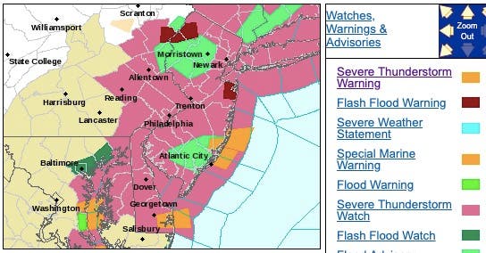
Here were the alerted areas as of 6:30 p.m.:
Find out what's happening in Lakewoodfor free with the latest updates from Patch.
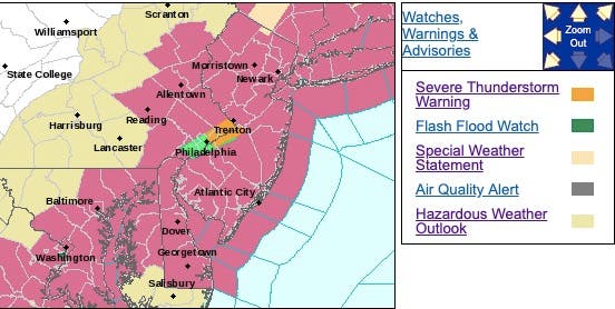
Here were the alerted areas as of 3 p.m.:

Here were the alerted areas as of 1:30 p.m.:
The NWS also has issued a hazardous weather outlook and a flash flood watch, saying there is a chance of thunderstorms happening during Wednesday afternoon and evening. Some of the storms may be severe, with damaging winds the primary threat.
The showers and thunderstorms are forecast to bring periods of heavy rain to New Jersey after 3 p.m. Rainfall totals of 1 to 2 inches are expected for some areas, with local amounts of up to 3 to 4 inches possible.
This rain could fall in a short period of time which could lead to areas of flash flooding. Wind gusts as strong as 60-mph or more are possible.
.png)
As heat and humidity hold on in the eastern United States, a slow-moving swath of drenching showers and thunderstorms will advance from the Appalachians to New Jersey and eventually stall, according to AccuWeather.
As the storms approach heavily populated areas, travel disruptions will increase with the potential for some roads to be blocked by rapidly rising water, according to AccuWeather.
Airline delays are likely as the storms approach and pass over airports.
.png)
Residents from central and eastern Maryland and Delaware to eastern Pennsylvania, New Jersey, southeastern New York and southern Connecticut could face more widespread incidents of violent wind gusts and flash flooding of streams, creeks and smaller rivers, according to AccuWeather.
"The afternoon commute could prove to be difficult and slow in the major cities, so motorists should be prepared for delays and reduce speeds in heavy downpours to lessen the risk for hydroplaning," AccuWeather Meteorologist Kyle Elliott said in a release.
.jpeg)
Here is the forecast:
- Wednesday: Showers and thunderstorms likely, mainly after 3pm. Some of the storms could produce gusty winds and heavy rain. Partly sunny, with a high near 88. West wind 3 to 7 mph. Chance of precipitation is 60%. New rainfall amounts between a half and three quarters of an inch possible.
- Wednesday night: Showers and thunderstorms likely, mainly before 3am. Some of the storms could produce gusty winds and heavy rain. Patchy fog after 2am. Otherwise, mostly cloudy, with a low around 67. Light and variable wind. Chance of precipitation is 60%. New rainfall amounts between a quarter and half of an inch possible.
Get more local news delivered straight to your inbox. Sign up for free Patch newsletters and alerts.