Weather
Barry Remnants To Produce Severe NJ Weather As Heat Wave Builds
UPDATE: NJ may see 'big' thunderstorms due to the remnants of Tropical Storm Barry. Severe heat is also on the way for NJ.


NEW JERSEY — New Jersey is now embarking on an impressive heat wave just as the remnants of Tropical Storm Barry are poised to bring strong to possibly severe thunderstorms on Wednesday afternoon and evening and also on Thursday. There may be torrential downpours during the thunderstorms.
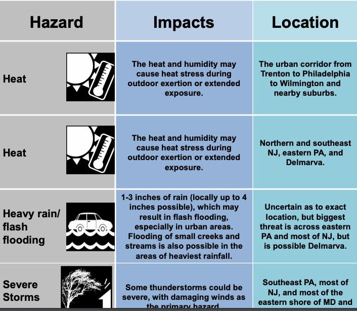
The National Weather Service has issued a statewide hazardous weather outlook since excessive heat is possible from Wednesday through Sunday. Heat Index values near or above 100 degrees will be possible Wednesday and Thursday, potentially reaching as high as 110 degrees on Friday and 115 degrees on Saturday.
Heavy rain and flooding is possible Wednesday night into Thursday as the remnants of Barry pass through New Jersey, according to the National Weather Service.
Find out what's happening in Manasquan-Belmarfor free with the latest updates from Patch.
.png)
Temperatures will be on the rise across the northeastern United States through the first half of this week before moisture from Barry arrives and triggers downpours, according to AccuWeather. While Monday felt like a typical summer day in the Northeast, temperatures and humidity levels will climb for Tuesday and Wednesday.
After temperatures begin to throttle up on Tuesday, highs in the 90s engulf nearly the entire Interstate-95 corridor on Wednesday, according to AccuWeather. Temperatures could soar between 95 and 105 these days.
Find out what's happening in Manasquan-Belmarfor free with the latest updates from Patch.
Spotty thunderstorms will ignite on Wednesday afternoon with more numerous showers and thunderstorms to follow at night and into Thursday as Barry's moisture surges eastward, according to AccuWeather.
"Given how much moisture will be in place, there is the potential for heavy rainfall with any showers or thunderstorms that do develop," AccuWeather Meteorologist Randy Adkins said in a release. "Fortunately, downpours should be moving along rather briskly, so the threat for widespread flash flooding is low."
Here is the updated weather forecast for New Jersey:
- Tuesday: Mostly sunny, with a high near 90. Southwest wind around 7 mph.
- Tuesday night: A slight chance of showers and thunderstorms. Mostly cloudy, with a low around 73. Southwest wind 6 to 8 mph. Chance of precipitation is 20%.
- Wednesday: A chance of showers and thunderstorms after 2pm. Partly sunny, with a high near 94. Heat index values as high as 103. Southwest wind 5 to 8 mph. Chance of precipitation is 40%. New rainfall amounts of less than a tenth of an inch, except higher amounts possible in thunderstorms.
- Wednesday night: A chance of showers and thunderstorms before 8pm, then showers likely and possibly a thunderstorm between 8pm and 2am, then a chance of showers and thunderstorms after 2am. Patchy fog. Otherwise, mostly cloudy, with a low around 74. Southwest wind 5 to 7 mph. Chance of precipitation is 60%. New rainfall amounts between a tenth and quarter of an inch, except higher amounts possible in thunderstorms.
- Thursday: A chance of showers and thunderstorms, then showers likely and possibly a thunderstorm after 2pm. Some of the storms could produce heavy rain. Mostly cloudy, with a high near 89. Southwest wind 5 to 7 mph. Chance of precipitation is 60%. New rainfall amounts between a quarter and half of an inch possible.
- Thursday night: Showers likely and possibly a thunderstorm before 8pm, then a chance of showers and thunderstorms after 8pm. Patchy fog. Otherwise, mostly cloudy, with a low around 72. Chance of precipitation is 60%. New rainfall amounts between a tenth and quarter of an inch, except higher amounts possible in thunderstorms.
Get more local news delivered straight to your inbox. Sign up for free Patch newsletters and alerts.