Weather
Hazardous Weather Outlook For Thunderstorms In NJ
Flooding is possible, too. Power outages could be an issue.


A hazardous weather outlook has been issued in New Jersey as thunderstorms are expected to move into the region on Sunday and Monday. A coastal flooding warning and a flash flood watch are in effect, too.
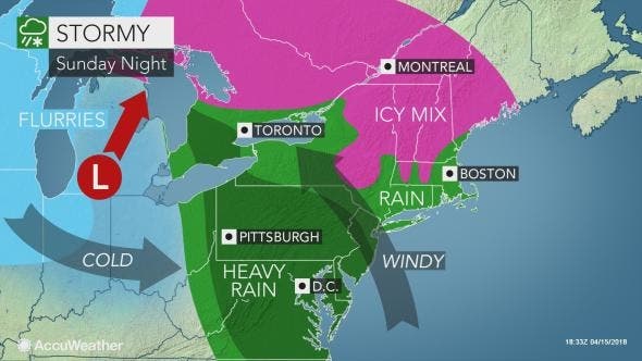
The National Weather Service says low pressure will bring rain that will heavy at times Sunday night, and thunderstorms that could cause power outages are possible throughout the state. This may result in some urban and small stream flooding issues in spots.
Low pressure will also bring rain that will be heavy at times on Monday. This may also result in some urban and small stream flooding issues in spots.
Find out what's happening in Manasquan-Belmarfor free with the latest updates from Patch.
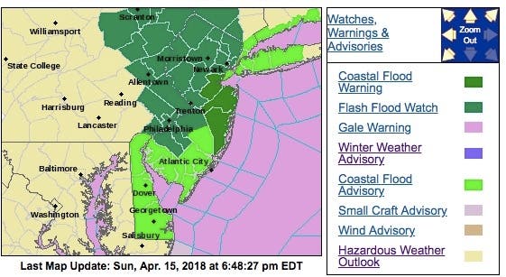
The National Weather Service has issued a coastal flood warning that is in effect from 6 p.m. Sunday evening to 1 p.m. Monday. Moderate flooding is possible with the high tides Sunday evening and Monday morning.
Here is what is expected:
Find out what's happening in Manasquan-Belmarfor free with the latest updates from Patch.
- Flooding may occur for a few hours around the time of high tide. High tide on the New Jersey oceanfront occurs between 8 and 9 p.m. Sunday evening, and between 8 and 9 a.m. Monday morning. High tide on the back bays and along Raritan Bay occurs later than the high tide on the oceanfront.
- A storm surge will be 2 to 3 feet above the astronomical tide Sunday evening and Monday morning, according to the NWS.
- For the high tides Sunday evening and Monday Morning, numerous roadways may flood and minor to moderate property damage is possible. The tides and wave action could result in moderate beach erosion. In addition, heavy rain tonight into Monday could further exacerbate impacts.
- A line of strong thunderstorms is expected to move through the area late tonight and Monday morning. Widespread rainfall totals of one to three inches are forecast, with locally higher amounts possible with the strongest storms. The storms will likely move out of the area by Monday afternoon.
- The storms are expected to move through the area just before or during the morning commute. Motorists should be prepared for torrential downpours and potential flooding as the storms move through.
Here is the forecast:
- Sunday Afternoon: Patchy drizzle and fog with a chance of rain before 5pm, then rain likely with patchy drizzle after 5pm. Cloudy, with a high near 42. East wind around 18 mph, with gusts as high as 33 mph. Chance of precipitation is 60%. New precipitation amounts of less than a tenth of an inch possible.
- Sunday night: Showers, with thunderstorms also possible after 2am. Some of the storms could produce gusty winds. Patchy fog. Low around 40. Breezy, with an east wind 18 to 20 mph. Chance of precipitation is 90%. New rainfall amounts between 1 and 2 inches possible.
- Monday: Showers and possibly a thunderstorm, mainly before noon, then a chance of showers and thunderstorms after noon. Some of the storms could produce gusty winds. High near 58. Breezy, with a south wind 16 to 22 mph. Chance of precipitation is 90%. New rainfall amounts between a half and three quarters of an inch possible.
- Monday night: A slight chance of showers before 2am. Mostly cloudy, with a low around 39. West wind 10 to 15 mph. Chance of precipitation is 20%.
- Tuesday: A slight chance of showers after noon. Mostly cloudy, with a high near 52. West wind 13 to 16 mph. Chance of precipitation is 20%.
Tom Davis photo
Get more local news delivered straight to your inbox. Sign up for free Patch newsletters and alerts.