Weather
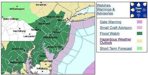
Hazardous Weather Outlook For Ugly Manasquan-Belmar Weekend
The weather will be "unseasonable" but not in a good way.


Get ready for some unseasonable weather this weekend. But it won't be what you might expect.
The weather will be warmer than usual, but drenching rain is expected to fall throughout New Jersey this weekend. The National Weather Service has issued a flood watch for most of the state.
The National Weather Service has also issued a hazardous weather outlook for all New Jersey, saying a prolonged period of heavy rain will overspread the region tonight through Sunday night.
Find out what's happening in Manasquan-Belmarfor free with the latest updates from Patch.
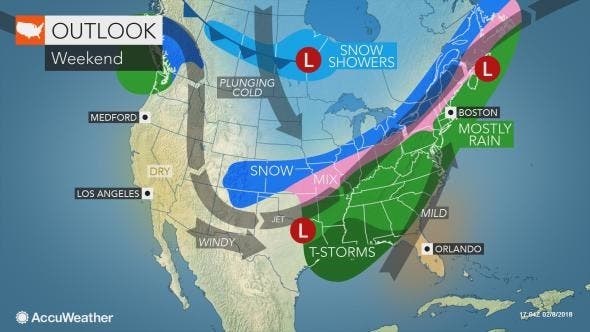
The heaviest rain will fall along the I-95 corridor, where between 2 and 3 inches of rain are expected to fall from northern Maryland and Delaware, through southeast Pennsylvania, and into most of New Jersey beginning Saturday night, according to the National Weather Service.
The NWS says low-lying flooding is likely where the heaviest rain occurs. In addition, rainfall amounts may result in flooding on area streams, creeks, and rivers by late Sunday.
Find out what's happening in Manasquan-Belmarfor free with the latest updates from Patch.
Temperatures will climb into the 40s and 50s. With the higher temperatures and moisture in the air, it may feel more like spring rather than the middle of winter, according to an AccuWeather release.
As the rain begins, the ground may be cold enough for patchy black ice in some areas of North Jersey. These icy spots will be most common near large piles of snow and in areas that do not receive direct sunshine on a clear day, according to the release.
Delays related to poor visibility are possible in Atlanta, Charlotte, North Carolina, Washington, D.C., Baltimore, Philadelphia, New Jersey, New York City and Boston, especially from later Saturday through Sunday, according to the release.
Here is the forecast:
- Saturday: Rain, mainly after 1pm. High near 52. Southwest wind 5 to 7 mph. Chance of precipitation is 80%. New precipitation amounts of less than a tenth of an inch possible.
- Saturday night: Rain. Patchy fog after midnight. Low around 45. Southwest wind around 6 mph. Chance of precipitation is 100%. New precipitation amounts between three quarters and one inch possible.
- Sunday: Periods of rain. The rain could be heavy at times. Patchy fog before noon. High near 57. Calm wind becoming southwest 5 to 7 mph in the morning. Chance of precipitation is 100%. New precipitation amounts between 1 and 2 inches possible.
- Sunday night: Periods of rain, mainly before midnight. Patchy fog after midnight. Low around 41. Southwest wind around 7 mph becoming northwest after midnight. Chance of precipitation is 80%. New precipitation amounts between a quarter and half of an inch possible.
- Monday: A chance of rain before noon. Mostly cloudy, with a high near 46. Northwest wind around 8 mph. Chance of precipitation is 30%. New precipitation amounts of less than a tenth of an inch possible.
Image via Shutterstock
Get more local news delivered straight to your inbox. Sign up for free Patch newsletters and alerts.