Weather
New Jersey Temperatures, Heat Index: Town-By-Town - 7/2/18
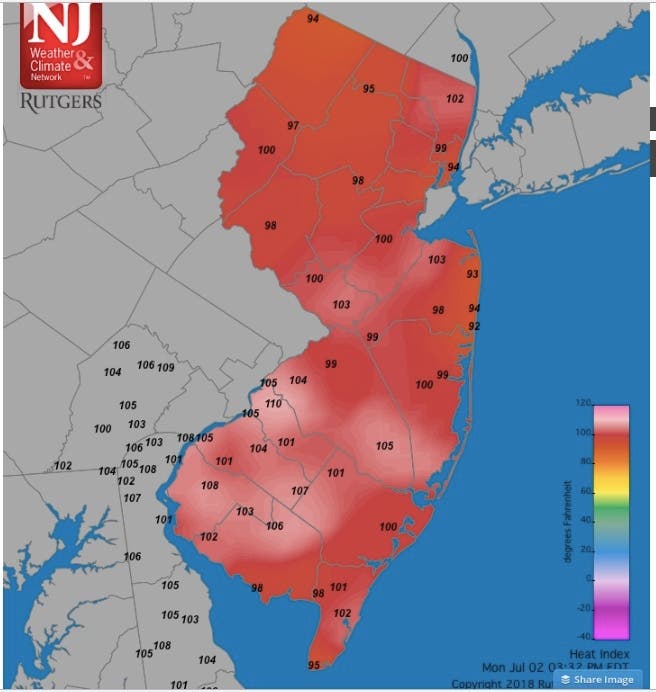
The heat index hit 110 degrees in parts of New Jersey on Monday, and it could get worse. See list below.


After hitting 111 degrees on Sunday, more of that ridiculous heat hit New Jersey on Monday as some heat indexes hit 110.
After parts of Mercer County and Monmouth County reached a 110- to 111-degree heat index on Sunday, parts of Camden County hit 110 on Monday. Parts of Monmouth and Middlesex counties hit 105 and higher.
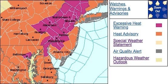
We are closely monitoring the heat as the state deals with possibly record-level temperatures across New Jersey. The National Weather Service has issued an excessive heat warning in most of the state.
Find out what's happening in Manasquan-Belmarfor free with the latest updates from Patch.
See the town-by-town heat indexes and temperatures below.
Here are the alerted areas, and below is the forecast:
Find out what's happening in Manasquan-Belmarfor free with the latest updates from Patch.
Below are the town-by-town list of temperatures across New Jersey on Monday, and below that is a map that shows the heat indexes in New Jersey towns (we will update):
- Atlantic City Marina 84
- Basking Ridge 95
- Berkeley Twp. 93
- Cape May Court House 90
- Charlotteburg 93
- Cherry Hill 96
- Columbus 97
- Cream Ridge 96
- Dennis Twp. 92
- Egg Harbor Twp. 90
- Fortescue 85
- Hackettstown 93
- Hamilton 95
- Hammonton 96
- Harvey Cedars 79
- Haworth 94
- Hawthorne 99
- High Point 91
- High Point Monument 87
- Hillsborough 95
- Holmdel 93
- Hopewell Twp. 95
- Howell 91
- Jersey City 88
- Kingwood 93
- Lyndhurst 91
- Mannington Twp. 94
- Mansfield 96
- Mullica Twp. 95
- Oceanport 88
- Parsippany 93
- Pennsauken 99
- Pequest 95
- Piney Hollow 97
- Pittstown 92
- Ramsey 93
- Red Lion 96
- Sea Bright 83
- Sea Girt 83
- Seaside Heights 81
- Sewell 97
- Sicklerville 96
- Silas Little 95
- South Harrison 97
- Stewartsville 95
- Toms River 92
- Upper Deerfield 95
- Wall Twp. 88
- Wantage 91
- West Creek 87
- Woodbine 92
- Woodstown 95
Here is the map showing heat indexes:
Here is the forecast:
- Monday night: Patchy fog after midnight. Otherwise, mostly clear, with a low around 73. South wind 3 to 6 mph.
- Tuesday: Isolated showers and thunderstorms after 2pm. Mostly sunny, with a high near 94. Heat index values as high as 102. Calm wind becoming south around 6 mph in the afternoon. Chance of precipitation is 20%.
- Tuesday night: Patchy fog after 2am. Otherwise, partly cloudy, with a low around 73. Southeast wind around 5 mph becoming calm in the evening.
YouTube photo/video
Get more local news delivered straight to your inbox. Sign up for free Patch newsletters and alerts.