Weather
NJ Weather: Hazardous Weather Outlook For Thunderstorms, Bad Heat
We could be looking at another day of triple-digit heat. And then it gets worse. Find out where and when.


You thought Monday was bad? Tuesday could be the same – or worse – as the heat index could hit triple digits in New Jersey.
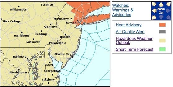
And then, brace yourself for some possible strong storms – again – since the National Weather Service has issued a hazardous weather outlook for yet another rough weather week.
Some areas of North Jersey are also under a heat advisory since the heat index is supposed to reach as high as 100 on Tuesday. The worst of the heat could come around 2 p.m.
Find out what's happening in Manasquan-Belmarfor free with the latest updates from Patch.
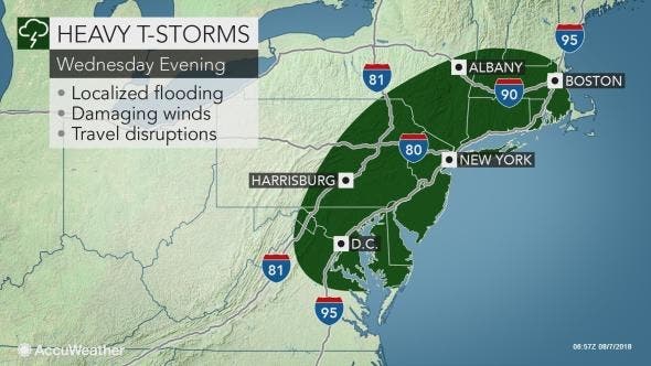
Much of New Jersey then could get torrential downpours and thunderstorms late Tuesday afternoon and evening that could lead to localized flooding, especially in areas of poor drainage.
Following a few days of stifling heat, New Jersey will get less hot air that won’t feel refreshing to most, as the high humidity is expected to stick around through midweek along with frequent showers and thunderstorms, according to AccuWeather.
Find out what's happening in Manasquan-Belmarfor free with the latest updates from Patch.
This wet weather will track eastward throughout Tuesday, overspreading New Jersey and reaching the Interstate-95 corridor on Tuesday night, according to AccuWeather.
While not everyone will experience a thunderstorm, AccuWeather said, any storms that do form will be heavy rain producers. Gusty storms that would normally be relatively harmless could easily uproot and topple trees in the very saturated soil.
The worst of the wet weather is supposed to come after 2 p.m. on Wednesday.
Here is the forecast:
- Tuesday: Mostly sunny, with a high near 90. South wind 6 to 9 mph.
- Tuesday night: A slight chance of showers and thunderstorms. Mostly cloudy, with a low around 76. South wind around 5 mph. Chance of precipitation is 20%.
- Wednesday: A chance of showers and thunderstorms, mainly after 2pm. Mostly cloudy, with a high near 90. Calm wind becoming southwest 5 to 8 mph in the afternoon. Chance of precipitation is 40%. New rainfall amounts of less than a tenth of an inch, except higher amounts possible in thunderstorms.
- Wednesday night: A chance of showers and thunderstorms before 2am. Mostly cloudy, with a low around 74. Southwest wind 3 to 6 mph. Chance of precipitation is 50%. New rainfall amounts of less than a tenth of an inch, except higher amounts possible in thunderstorms.
- Thursday: Mostly sunny, with a high near 86. West wind around 7 mph.
Tom Davis photos
Get more local news delivered straight to your inbox. Sign up for free Patch newsletters and alerts.