Weather
NJ Weather: Heavy Thunderstorms Possible Overnight
The National Weather Service has issued a hazardous weather outlook. Find out what's in the forecast.

The National Weather Service has issued a hazardous weather outlook, saying heavy rain and thunderstorms are likely overnight Wednesday into Thursday in some parts of New Jersey.
NWS forecasters say widespread showers with thunderstorms could bring enough rain that some flash flooding could occur. Flooding of small streams and urban areas is also possible.
The Weather Channel is also warning of severe thunderstorms overnight, saying the worst will happen after midnight and before dawn. Showers could linger through about 6 a.m. Skies should clear by mid-morning, according the Weather Channel's forecast.
Find out what's happening in Manasquan-Belmarfor free with the latest updates from Patch.
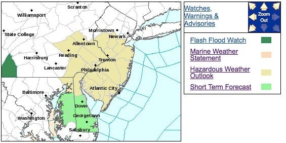
Here are the alerted areas:
Here is the NWS forecast for the next 24 hours:
Find out what's happening in Manasquan-Belmarfor free with the latest updates from Patch.
- Tonight: Showers and possibly a thunderstorm before 2am, then showers likely. Some of the storms could produce heavy rainfall. Low around 66. Calm wind becoming north around 5 mph after midnight. Chance of precipitation is 90%. New rainfall amounts between a quarter and half of an inch possible.
- Thursday: A chance of showers between 8am and 1pm. Partly sunny, with a high near 85. Northeast wind around 9 mph. Chance of precipitation is 40%. New precipitation amounts of less than a tenth of an inch possible.
- Thursday Night: Partly cloudy, with a low around 64. Light and variable wind becoming northeast around 5 mph after midnight.
With reporting by Kara Seymour
Shutterstock photo
Get more local news delivered straight to your inbox. Sign up for free Patch newsletters and alerts.