Weather
NJ Weather: Strong-To-Severe Thunderstorms On Labor Day Possible
Here's when and where those storms are expected to hit NJ. Hurricane Dorian, meanwhile, already could be impacting the Jersey Shore.

NEW JERSEY – Strong and even severe storms were possible in New Jersey on Labor Day while Hurricane Dorian already could be having an impact on the Jersey Shore.
The National Weather Service issued a hazardous weather outlook for nearly the entire state, saying showers and thunderstorms were possible during the afternoon and evening (see forecast below).
Most of the storms, which are not connected to Hurricane Dorian, will likely arrive in North and Central Jersey after 10 a.m. and after 2 a.m. Strong rip currents possibly caused by the massive hurricane, however, are impacting the entire Jersey Shore.
Find out what's happening in Manasquan-Belmarfor free with the latest updates from Patch.
Read more: Hurricane Dorian: Here's When It Could Impact New Jersey
A few storms on Labor Day, meanwhile, may be strong to severe with a primary threat of strong winds, the National Weather Service said.
Find out what's happening in Manasquan-Belmarfor free with the latest updates from Patch.
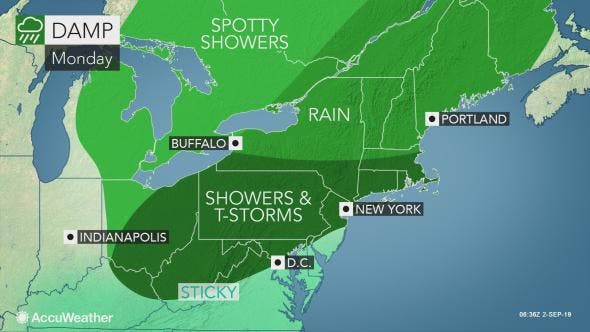
The weather pattern will be active across the Northeast this week as two separate, non-tropical storm systems sweep through the region prior to Dorian's arrival, according to AccuWeather.
Those heading outdoors to partake in any last-minute activities will need to bring along the rain gear, according to AccuWeather. The majority of the activity will wait until the afternoon and evening.
.png)
Here is the forecast:
- Labor Day: Showers and thunderstorms likely, mainly before 2pm, then showers likely and possibly a thunderstorm after 4pm. Some of the storms could produce gusty winds. Mostly cloudy, with a high near 81. South wind 7 to 9 mph. Chance of precipitation is 70%. New rainfall amounts between a tenth and quarter of an inch, except higher amounts possible in thunderstorms.
- Monday night: Showers likely and possibly a thunderstorm before 8pm, then a chance of showers and thunderstorms, mainly between 8pm and 4am. Some of the storms could produce gusty winds. Patchy fog after 2am. Otherwise, cloudy, then gradually becoming partly cloudy, with a low around 64. South wind around 5 mph becoming light and variable in the evening. Chance of precipitation is 60%. New rainfall amounts between a quarter and half of an inch possible.
- Tuesday: Patchy fog before 8am. Otherwise, sunny, with a high near 80. North wind around 6 mph becoming light and variable in the afternoon.
- Tuesday night: Mostly clear, with a low around 65. South wind around 7 mph
Get more local news delivered straight to your inbox. Sign up for free Patch newsletters and alerts.