Weather
NJ Weather: Two Chances For Snow As Possible Storms Loom
A hazardous weather outlook has been issued for two NJ storms, one of which may be "significant."


The Nation Weather Service has issued a hazardous weather outlook for New Jersey since two possible snowstorms could hit the state beginning on Thursday. Police said they actually received an advisory from local weather services regarding the weather, and that roads may be hazardous during the event.
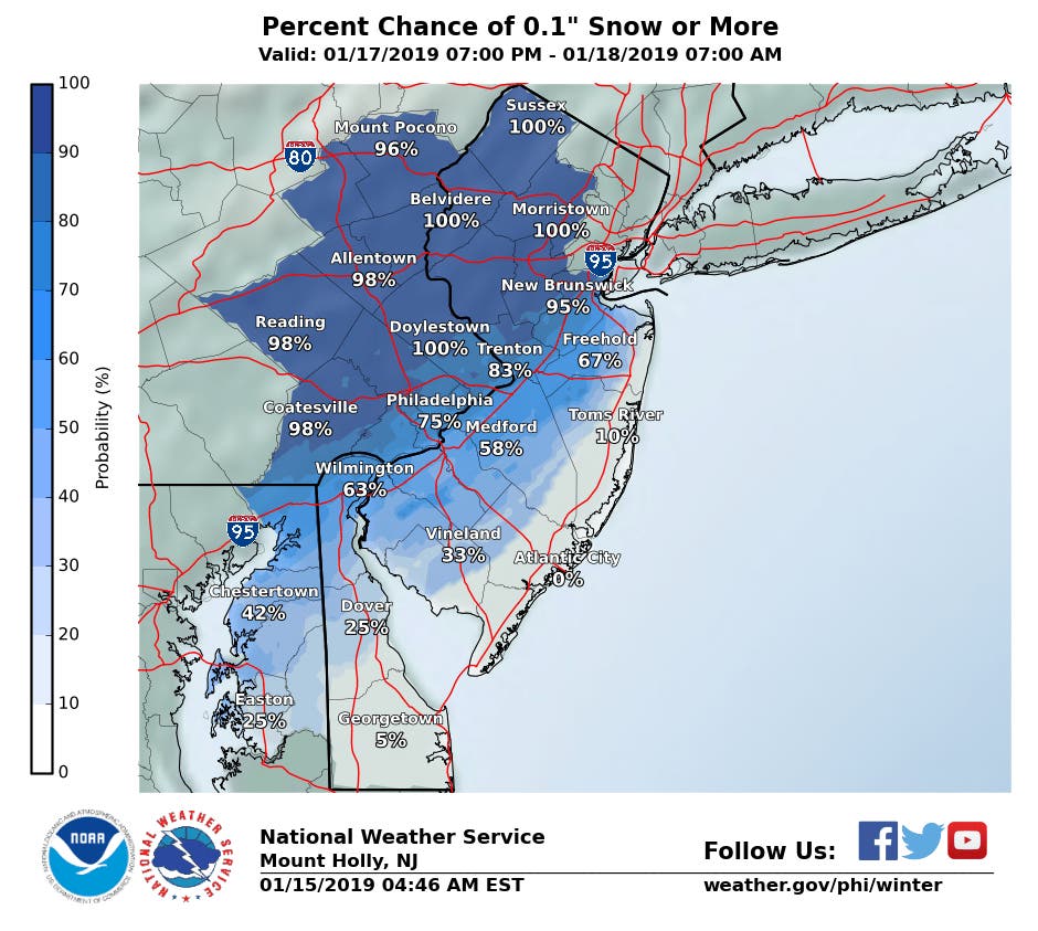
The NWS says some accumulating snow is expected with the highest amounts in northwestern New Jersey, beginning with the Thursday commute, and on Friday. Hazardous travel is possible, and the storm may have a higher impact on the Friday morning commute.
As many as 3 inches could fall in parts of New Jersey. The snow on Thursday night and Friday could impact schools. Read more: New Jersey School Closings/Delayed Opening List For 1/18/19
Find out what's happening in Manasquan-Belmarfor free with the latest updates from Patch.
For Saturday and Sunday, a "significant winter storm" impacting the entire state is probable. Details including precipitation types and impacts are less certain at this time. A flash freeze is possible Sunday afternoon and night as arctic air pours into the area.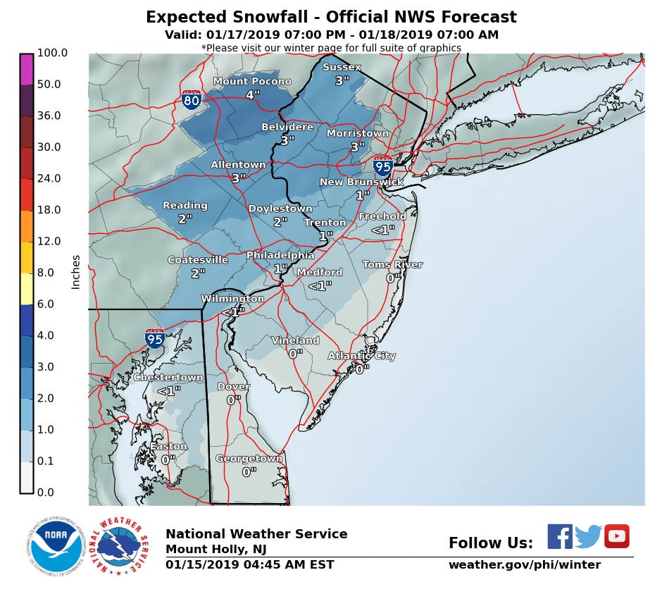
-1547574495-5298.jpg)
South Brunswick police spelled out the conditions this way:
Find out what's happening in Manasquan-Belmarfor free with the latest updates from Patch.
- Drivers should use reduce speeds and allow extra time during their commutes.
- A west-to-east system will produce light precipitation Thursday Night and depart around daybreak Friday.
- There's high confidence that New Jersey will see only snow on Thursday.
- Watch for coverings on all surfaces at night, and when temperatures are below-freezing, on Thursday.
- On Friday, the snow will become a memory quickly as temps warm into the 40s.
- The weekend storm is "significant," with rain to go along with wintry weather.
- The main snow risk is on the front-side (Saturday night) before we go to mainly rain.
- We may go back to snow on the back-side of the storm on Sunday and on Sunday night, but the main takeaway will be "crashing" temperatures as Arctic air could lead to a freeze-up of wet surfaces.
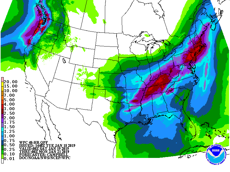
Indeed, more snow is likely this weekend as a larger, more potent storm takes shape following the storm late this week, according to AccuWeather.
The storm coming this weekend has the potential to put down close to a foot of snow over a long swath in the Midwest and Northeast with the worst conditions likely from I-80 on north, but perhaps as far south as portions of the Pennsylvania and New Jersey turnpikes, according to an AccuWeather release.
"Cold air in the wake of the storm on Thursday and Friday, combined with extensive snowcover, may cause the storm that follows to track farther south than our indicators suggest," AccuWeather Lead Long-Range Meteorologist Paul Pastelok said in the release.
AccuWeather meteorologists still expect a surge of warm air during the storm along the Atlantic coast as a counterbalance to the cold plunge that will first unfold over the Midwest. This warm surge is likely to bring rain or a wintry mix at the height of the storm from Washington, D.C., to Baltimore, Philadelphia, New York City and Boston as well as along the immediate coast of Maine, according to AccuWeather.
"However, we are still concerned about a dose of heavy snow during the first part of the storm in much of the I-95 Northeast, which could lead to difficult travel," according to AccuWeather Chief Meteorologist Elliot Abrams.
-1547573156-6728.jpg)
Here is the forecast:
- Wednesday: Mostly sunny, with a high near 39. West wind 10 to 13 mph.
- Wednesday night: Partly cloudy, with a low around 23. West wind 7 to 9 mph becoming north after midnight.
- Thursday: Partly sunny, with a high near 33. North wind around 6 mph becoming light and variable.
- Thursday night: Snow possible before 4am, then rain and snow. Low around 29. Chance of precipitation is 80%. New precipitation amounts between a tenth and quarter of an inch possible.
- Friday: Rain and snow showers before 7am, then a chance of rain showers between 7am and 10am. High near 45. Chance of precipitation is 80%.
- Friday night: Partly cloudy, with a low around 27.
- Saturday: A chance of rain between 1pm and 4pm, then a chance of snow after 4pm. Mostly cloudy, with a high near 39. Chance of precipitation is 50%.
- Saturday night: A chance of snow before 7pm, then rain and snow likely between 7pm and 10pm, then rain after 10pm. Low around 32. Chance of precipitation is 80%.
- Sunday: Rain and snow likely. Cloudy, with a high near 41. Chance of precipitation is 70%.
- Sunday night: Snow or rain likely. Mostly cloudy, with a low around 13. Chance of precipitation is 60%.
- M.L.King Day: Mostly sunny, with a high near 25.
NWS photo
Get more local news delivered straight to your inbox. Sign up for free Patch newsletters and alerts.