Weather
Gov. Christie, NWS Spar Over N.J. Blizzard Predictions That Fell Short
The National Weather Service knew by Monday afternoon that its NYC snow projections were too high — but decided against alerting the public.

Looks like everybody had something to complain about regarding the so-called blizzard of 2017.
One of them was New Jersey Gov. Chris Christie, who sparked a not-so-pleasant exchange this week with National Weather Service meteorologists whose predictions that a blizzard would blanket nearly all of New Jersey fell short.
National Weather Service officials admitted Wednesday that they knew as soon as Monday afternoon that Tuesday's storm wouldn't be nearly as dramatic as previously predicted — but decided not to tell the public.
Find out what's happening in Mendham-Chesterfor free with the latest updates from Patch.
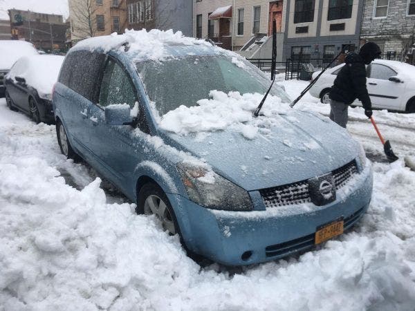
Christie, in turn, took a shot at the National Weather Service for the "underperformer" snowstorm that still did have a severe impact on much of the state, dumping nearly 2 feet of snow in North Jersey. Many towns are still digging out, and many spring sports and activities have been canceled.
Find out what's happening in Mendham-Chesterfor free with the latest updates from Patch.
"I've had my fill after the last seven and a half years of the National Weather Service, to tell you the truth," Christie told reporters in a briefing on the storm recovery.
Gary Szatkowski, the former chief meteorologist in Mount Holly, fired back at the governor and called for a "more responsible perspective" from Christie.
"It's a great disappointment to hear the governor speak that way about the National Weather Service," Szatkowski told The Philadelphia Inquirer. "The Mount Holly office is a highly regarded office with the NWS, and deserves better treatment than that."
Szatkowski then took a shot at Christie's performance as governor, saying the NWS provided an "outstanding forecast service" before Superstorm Sandy hit New Jersey but said the Christie administration "mishandled" that information in a "disastrous way."
Szatkowski, who is active on Twitter, had little to say on social media about the exchange Thursday other than referring people to his comments in the Inquirer and on Fox News' website.
More of my comments in the news. I do have to confess that I am pretty bad at this retirement thing. https://t.co/MCFfjroOxQ
— Gary Szatkowski (@GarySzatkowski) March 15, 2017
Federal weather forecasters played up the incoming "blizzard," saying it could likely dump at least 2 feet snow throughout much of the state. As projected, the storm still became one of the biggest snowstorms ever to hit New Jersey in the month of March.
On Monday, the National Weather Service's computer models began showing snowfall projections for the region were wrong, a spokeswoman for the federal agency said.
Instead of letting snow-fearing citizens in central and southern New Jersey and New York City know they were only in for about 4 to 8 inches of snow, National Weather Service officials decided not to update snowfall projections until morning, once the storm had already hit.
Their reasoning? In short: Sleet and freezing rain are also dangerous, and it's best not to confuse people.
"This was the prudent thing to do," an NWS spokeswoman told Patch in a statement, "as making a dramatic change in the snowfall forecast and risking having to flip back and forth could produce an unwelcome result of less readiness and vigilance."
"There was still going to be a large impact on the morning commute in many areas," she said, "despite the lower snowfall beginning to show up in some, but not all, of the forecasts."
The service's head forecast honcho said in an interview with the Associated Press that telling people the truth about what kind of weather to expect could end up causing what is called "the windshield wiper effect." Dramatically changing a forecast can cause more confusion than clarity, Greg Carbin, chief of forecast operations at the Weather Prediction Center, told the AP.
"The nature of the beast is that there's always uncertainty in every forecast and we have to get better at describing that," Carbin said.
For future storm forecasts, the NWS will try to more clearly present the least likely, most likely and worst case scenarios, in an attempt to better emphasize the uncertainty, a spokeswoman told Patch.
A rapid shift in Stella's track caused "a quicker and farther north transition to mixed precipitation and rain," putting NYC and central and southern areas of New Jersey right on the split between rain and snow, the National Weather Service had explained as the situation unfolded.
With reporting by Simone Wilson
Photo by Simone Wilson/Patch
Get more local news delivered straight to your inbox. Sign up for free Patch newsletters and alerts.