Weather
Tornado, 2” Hail, Flooding Risk Updated As Severe Storm Heads To NJ
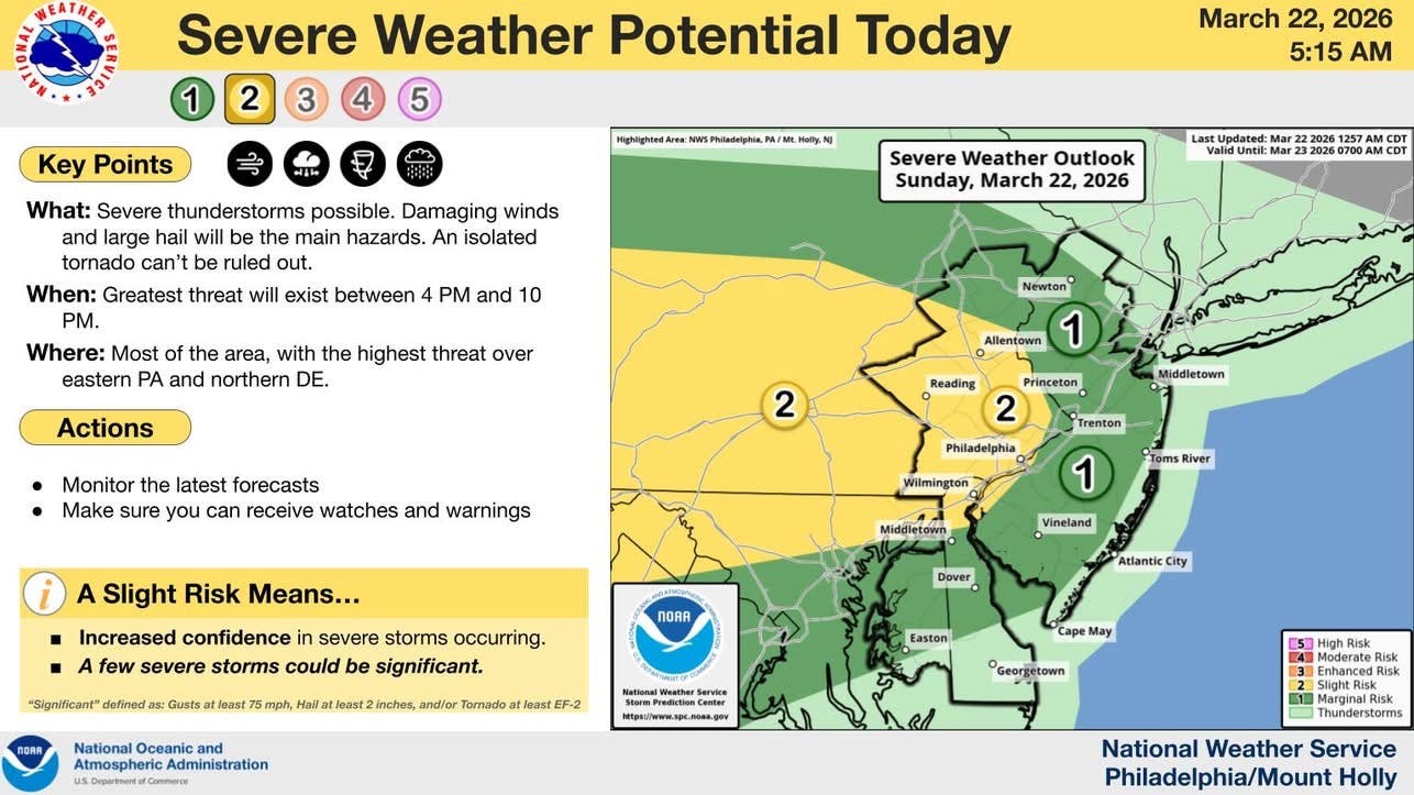
Damaging winds and large hail are the main threats Sunday, with an isolated tornado and flash flooding also possible, forecasters said.

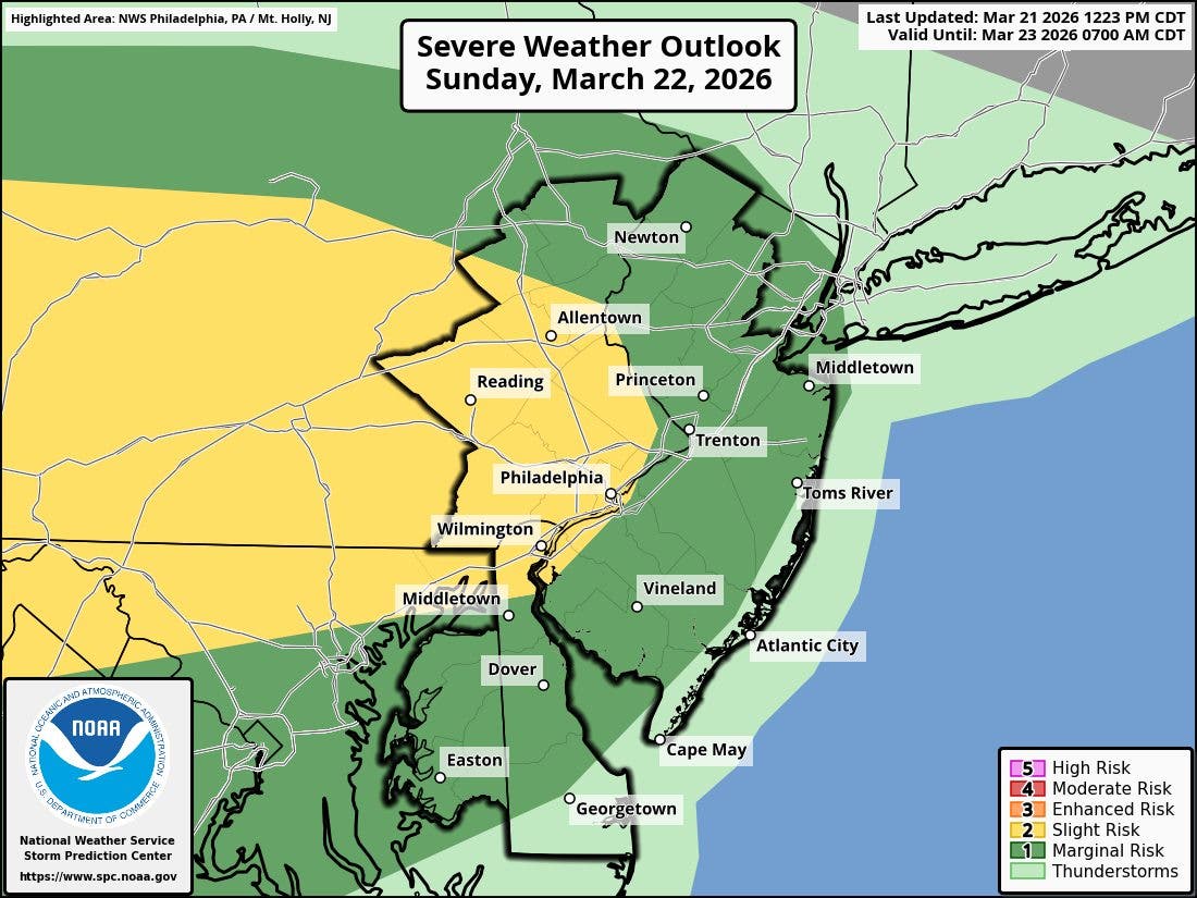
Severe thunderstorms are headed to the Garden State late Sunday afternoon and evening, with the main threats listed as damaging straight-line winds and large hail, according to the National Weather Service.
Forecasters say an isolated tornado cannot be ruled out, nor can isolated instances of flash flooding. The best timing for the strongest weather is 4 p.m. to 10 p.m., officials said.
Damaging winds and hail up to 2" in diameter are possible, forecasters said in a Sunday update. The best chance of an isolated tornado is in the far western portions of New Jersey, according to the NWS.
Find out what's happening in Mendham-Chesterfor free with the latest updates from Patch.
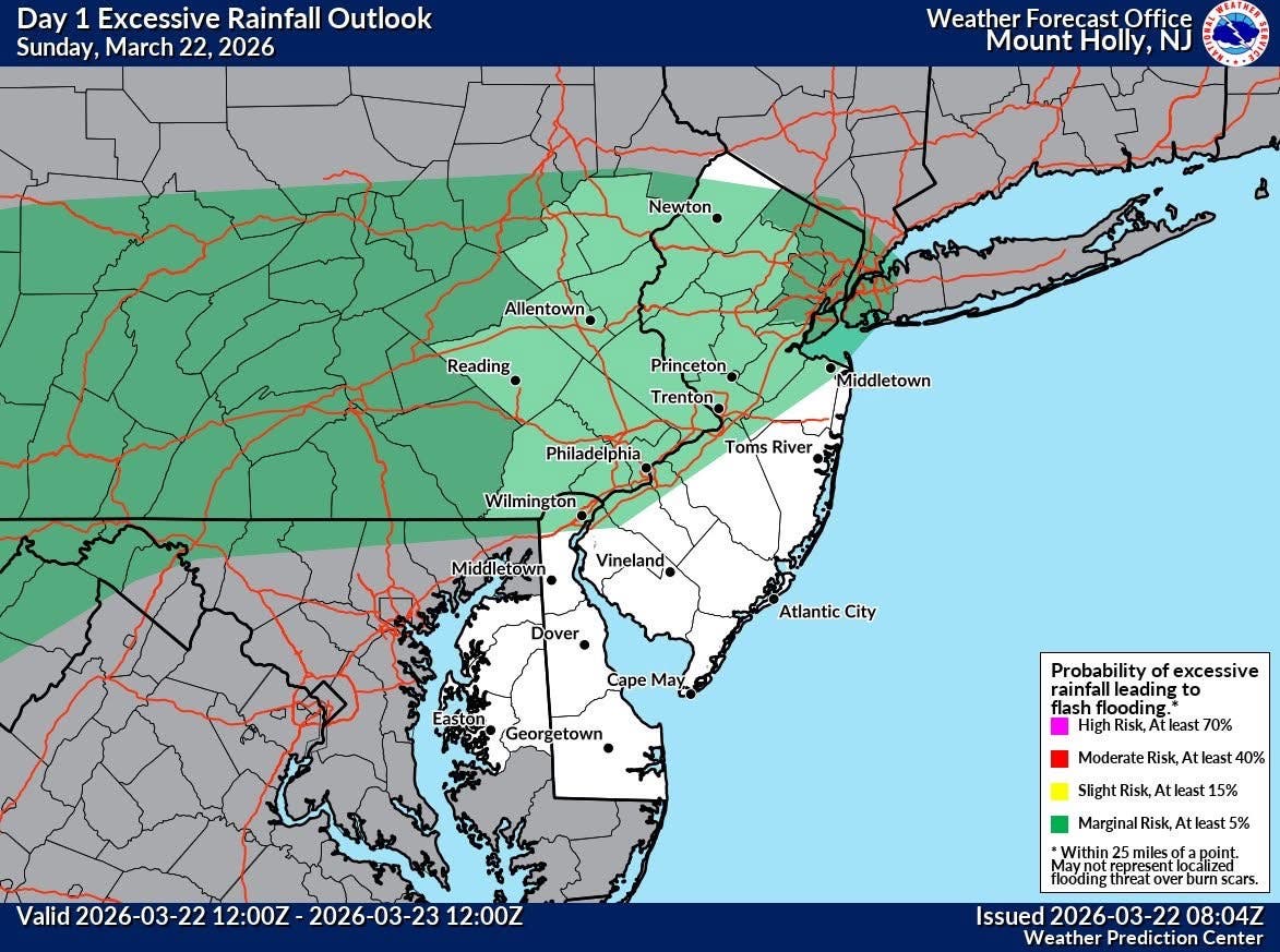
Flash flooding risk from heavy rainfall this evening into tonight is most likely along and north and west of I-95, forecasters noted.
Governor Mikie Sherrill warned residents to take the Sunday storm seriously.
Find out what's happening in Mendham-Chesterfor free with the latest updates from Patch.
“Some storms could turn severe – bringing damaging winds, large hail, and heavy rain that may cause localized flooding,” Sherrill said. “Monitor your local forecast, charge your devices, and stay safe.”
Before storms arrive, the forecast calls for cloudy skies that will gradually become mostly sunny, with a high near 68. Southwest wind is expected at 5 to 10 mph, with gusts as high as 20 mph.
Conditions are then expected to change Sunday night, when there is a chance of showers and thunderstorms before 8 p.m., followed by showers and possibly a thunderstorm between 8 p.m. and 11 p.m., and showers after 11 p.m.
The Sunday night low is expected to be around 42, with a north wind around 5 mph. The chance of precipitation is 90 percent, and new precipitation amounts between a quarter and half of an inch are possible. The forecast also notes that isolated flash flooding cannot be ruled out during the storm window.
The weather is expected to improve Monday, although a chance of showers remains before 2 p.m. Monday is forecast to be cloudy through midmorning, then gradually clear, with a high near 51. North wind will be around 15 mph. The chance of precipitation is 30 percent, with new precipitation amounts between a tenth and quarter of an inch possible.
Monday night is expected to turn mostly clear, with a low around 30 and northwest wind at 5 to 15 mph. Tuesday is forecast to be sunny, with a high near 49, followed by a mostly cloudy Tuesday night with a low around 33. Mostly cloudy skies are expected Wednesday, with a high near 56, before another chance of rain arrives Thursday between 8 a.m. and 2 p.m.
Rain is likely Thursday night, when the chance of precipitation rises to 60 percent and the low is expected near 42. Friday is forecast to be mostly sunny, with a high near 52, followed by a partly cloudy Friday night with a low around 28. The forecast for next Saturday calls for sunny skies and a high near 47.
Residents with outdoor plans late Sunday may want to keep a close eye on changing conditions during the 4 p.m. to 10 p.m. window, when the risk for severe weather is expected to be highest. After that, the forecast points to cooler but quieter weather for the start of the new week.
Get more local news delivered straight to your inbox. Sign up for free Patch newsletters and alerts.