Weather
Updated Snow Map Released For Inbound NJ Storm
A second shot of winter weather is headed for New Jersey, and then forecasters said the region can expect a dramatic weather shift.

A shot of snow started off Sunday in the Garden State and there is more winter weather on the way, according to the latest forecast.
Warm temperatures were the highlight Saturday before a fast-moving cold front blew in overnight, and the see saw of temperatures is expected to continue this week.
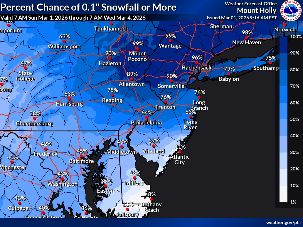
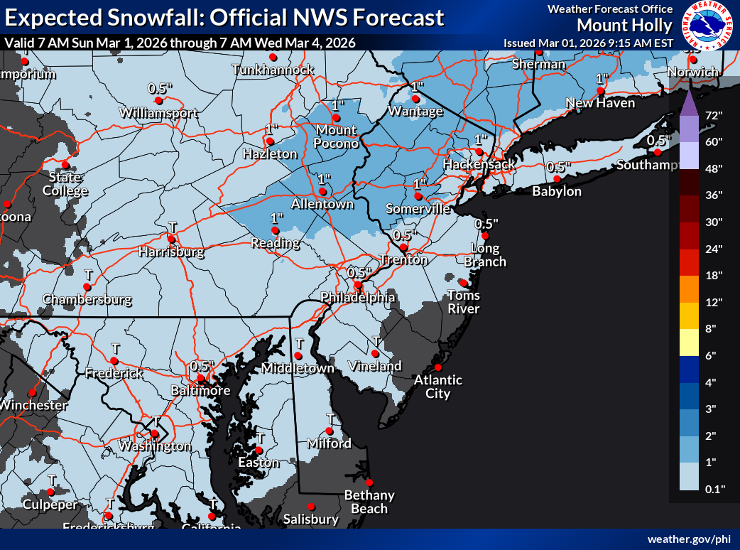
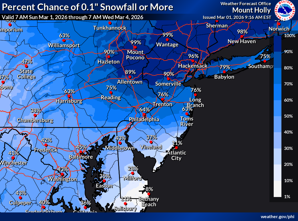
Monday night will usher in periods of snow, sleet, and freezing rain that will continue into Tuesday morning. Accumulation as of now is projected to be low, up to 1" followed by rain and drizzle in the afternoon.
Find out what's happening in Mendham-Chesterfor free with the latest updates from Patch.
“Snow and freezing rain may impact the area during the Tuesday morning commute,” the National Weather Service said.
An arctic front is expected to bring a period of wintry precipitation into the area, mainly north of the PA Turnpike and I-195 in NJ Monday night
Find out what's happening in Mendham-Chesterfor free with the latest updates from Patch.
At the onset, there is a threat for some spotty freezing rain as surface temps will be around freezing and a warm nose aloft lingers with the stalled boundary nearby. As colder air slowly infiltrates south, precipitation should change over to a period of light snow before ending
Any ice accretion would be sporadic in nature and confidence in occurrence is low, forecasters said.
Elsewhere, mainly just some rain showers are expected through the morning, before ending by early afternoon. Perhaps a stray snowflake may mix in before precipitation ends.
A spring-like warmup will develop over the area starting on Wednesday and continuing through at least Saturday. For some areas, highs will be some 15 to 20 degrees above normal, especially starting on Thursday.
Bermuda high pressure sets up off the Southeast and Mid-Atlantic coasts for the middle to the end of the week. Highs on Wednesday will generally be in the mid to upper 50s for southeast Pennsylvania and New Jersey. Forecasters note that Thursday temperatures could go over 65 degrees across southeast Pennsylvania and New Jersey, generally south of I-78. A weak cold front knocks temperatures down by some 5 to 10 degrees on Friday, then the warmth returns for Saturday.
Current predictions show the chance of high temperatures over 65 north of I-78, and 40 to 60 percent across the rest of southeast Pennsylvania and southern New Jersey and some spots, mainly inland, may exceed 70.
Get more local news delivered straight to your inbox. Sign up for free Patch newsletters and alerts.