Weather
Storm Track Shift Increases Severe Weather Chances In NJ This Weekend
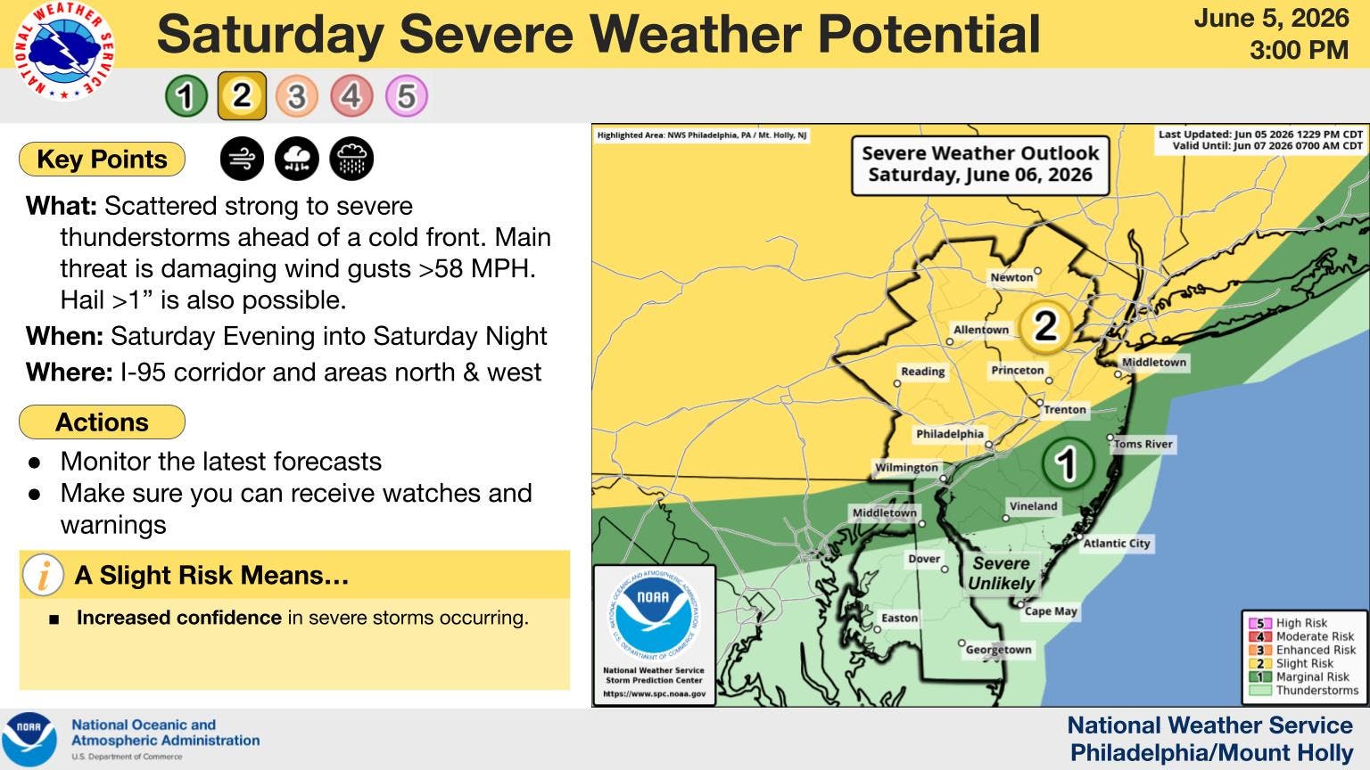
Wind gusts and hail have the potential to be damaging, according to weather experts.

A cold front, hail, and potentially severe thunderstorms, while breaking this week's several-day heat wave, could dampen weekend plans in New Jersey, according to forecasters.
The National Weather Service says a cold front can be expected to be accompanied by severe thunderstorms Saturday night into early Sunday morning.
Forecasters added that some damaging wind gusts could be in store with the storms. Wind gusts could reach up to nearly 60 mph, experts warn.
Find out what's happening in Morristownfor free with the latest updates from Patch.
There is also a chance of hail, larger than one inch, falling Saturday night, according to officials.
While temperatures are expected to exceed 90 degrees on Saturday afternoon, residents can expect a roughly 20-degree drop as Saturday evening approaches.
Find out what's happening in Morristownfor free with the latest updates from Patch.
Officials say the most severe weather will likely occur north and west of the I-95 corridor.
However, come Sunday, temperatures are expected to bounce back to the high 80s once the storms clear up, experts say.
See the forecast below:
- Friday night: Partly cloudy, with a low around 70. Southwest wind 3 to 5 mph.
- Saturday: Increasing clouds, with a high near 93. Southwest wind 6 to 16 mph, with gusts as high as 28 mph.
- Saturday night: A 50 percent chance of showers and thunderstorms before 2 a.m. Mostly cloudy, then gradually becoming mostly clear, with a low around 71. West wind 7 to 11 mph, with gusts as high as 22 mph.
- Sunday: A 20 percent chance of showers and thunderstorms after 2 p.m. Sunny, with a high near 88. West wind 8 to 13 mph.
- Sunday night: Mostly clear, with a low around 66. North wind 9 to 11 mph, with gusts as high as 21 mph.
- Monday: Sunny, with a high near 81.
- Monday night: Mostly clear, with a low around 61.
- Tuesday: Sunny, with a high near 87.
- Tuesday night: Mostly clear, with a low around 67.
- Wednesday: Mostly sunny, with a high near 92.
- Wednesday night: Partly cloudy, with a low around 71.
Get more local news delivered straight to your inbox. Sign up for free Patch newsletters and alerts.