Weather
NJ Weather: More Snow Could Follow 'Life-Threatening' Cold
Somebody just wake us when it's spring.


What is being described by law enforcement as "life threatening" cold will be followed by another chance for snow early next week. A deep freeze has set in throughout New Jersey, with record-setting cold anticipated through the weekend.
Saturday night's low temperature will be minus 4 across New Jersey, according to the National Weather Service. With the windchill, temperatures will fall like they're in the double-digit negative, ranging from minus 5 to minus 20.
Winds will gust as high as 45 mph through Friday and Saturday, causing areas of blowing and drifting snow with the existing snow pack. In addition, minor tree damage is possible, according to the National Weather Service.
Find out what's happening in Morristownfor free with the latest updates from Patch.
The cold and the snow forecast follow the "bomb cyclone" storm that dropped as many as 18 inches in some areas of New Jersey.
Find out what's happening in Morristownfor free with the latest updates from Patch.
A hazardous weather outlook and a wind chill advisory have been issued throughout the state, according to the NWS. Read more: How to Prevent Your Pipes From Freezing As Temps Drop
The brutal cold presents a serious safety issue, authorities say. "Everyone should be prepared for circumstances of both home and travel, and have contingencies to protect yourself," according to the Hunterdon County Department of Public Safety.
"Consider in advance what you’ll do if you happen to lose power or if your heating system fails?" the department asked in a Facebook post. "Where can you go? Who can you stay with?"
"Stay safe and warm, and take a minute to check-in on family, friends and neighbors to be sure they’re prepared for a weekend of well below zero conditions."
In addition to bone-chilling cold, the winds are causing snow to blow onto the roadways, making for dangerous travel conditions.
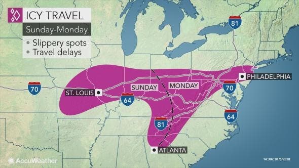
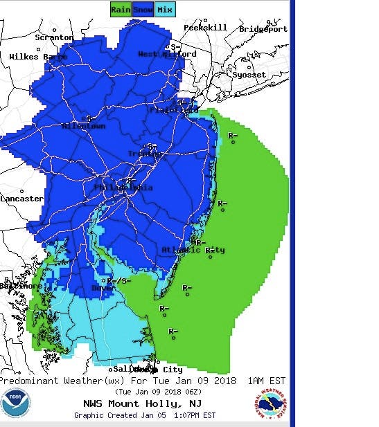
Once the severe cold passes, there is another chance for more snow Monday, the National Weather Service reported. The agency estimates there is a 30 percent chance of snow in New Jersey on Monday afternoon. The likelihood of snow increases at night, when there is a 60 percent chance. Accumulation estimates have not yet been released.
But there is a light at the end of this cold and snowy tunnel. The high temperature Tuesday will be in the low 40s, which means pipes should thaw and some of the snow and ice will melt.
Here is the forecast (read on if you dare):
Today: Areas of blowing snow. Mostly sunny, with a high near 14. Wind chill values as low as -5. Breezy, with a west wind around 21 mph, with gusts as high as 39 mph.
Tonight: Areas of blowing snow. Mostly clear, with a low around 7. Wind chill values as low as -8. West wind 11 to 14 mph, with gusts as high as 25 mph.
Saturday: Areas of blowing snow. Sunny, with a high near 13. Wind chill values as low as -8. Northwest wind 11 to 18 mph, with gusts as high as 31 mph.
Saturday Night: Mostly clear, with a low around -4. Wind chill values as low as -13. Northwest wind 5 to 11 mph.
Sunday: Mostly sunny, with a high near 19. Calm wind becoming west around 6 mph in the afternoon.
Sunday Night: Mostly cloudy, with a low around 12.
Monday: A chance of snow after 1pm, mixing with rain after 3pm. Mostly cloudy, with a high near 35. Chance of precipitation is 30%.
Monday Night: Snow likely. Cloudy, with a low around 30. Chance of precipitation is 60%.
Tuesday: Partly sunny, with a high near 41.
With reporting by Kara Seymour
PHOTO: NWS
Get more local news delivered straight to your inbox. Sign up for free Patch newsletters and alerts.