Weather
Heavy Snow In Newark Weather Forecast; Code Blue Declared (UPDATED)
Say it 'aint snow, Newark. Here's the local weather forecast for the week.

NEWARK, NJ — Say it ‘aint snow, Newark.
Significant changes to this week’s winter storm forecast in New Jersey now include predictions of widespread heavy snowfall, coastal flooding and fierce winds capable of causing power outages, forecasters say.
Between 8 to 12 inches of snowfall is possible in North Jersey and 1 to 3 inches are possible in Central Jersey during Tuesday's overnight storm, the National Weather Service said. Read More: Foot Of Snow Possible As Winter Storm Targets NJ
Find out what's happening in Newarkfor free with the latest updates from Patch.
A Hazardous Weather Outlook and a Winter Storm Watch are in effect for the Newark area until Tuesday afternoon.
>> Want to get local weather updates in Newark? Sign up for free Patch email newsletters here.
Find out what's happening in Newarkfor free with the latest updates from Patch.
The Newark Department of Public Safety is reminding drivers to watch where they park and follow “No Parking on Snow Covered Roadways” signs if the snow starts coming down.
Got some shoveling to do? “All residents are reminded that tossing snow into the street is against the law,” Newark authorities say.
Authorities said local residents should use flashlights instead of candles if they lose electricity. For non-emergency weather-related incidents, call: 973-733-6000. For emergencies, dial 911.
The Newark Public School District will be closed on Tuesday, Feb. 13 due to the weather forecast. Read More: Schools Closed Tuesday Due To Snowstorm In Forecast
Meanwhile, the city has declared a Code Blue alert that will begin at 8 a.m. on Tuesday, Feb. 13 and continue until 10 a.m. on Thursday, Feb. 15. Code Blues are called in Newark when temperatures are expected to fall to 32 degrees, or when there is a wind chill factor of zero degrees.
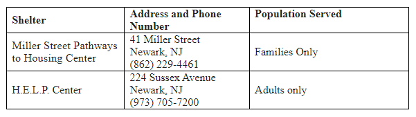
During Code Blue alerts, emergency shelters are open for people experiencing homelessness and others in need. For more information, contact the shelters listed below, or the Office of Homeless Services at: (973) 877-9481, Monday through Friday, 8:30 a.m. to 4:30 p.m.
LOCAL WEATHER FORECAST
According to the National Weather Service forecast (as of Monday morning), here’s what is expected in the Newark area this week:
Monday Night: Rain after 10pm, mixing with snow after 4am. Low around 32. Wind chill values between 25 and 30. Light east wind becoming northeast 9 to 14 mph in the evening. Chance of precipitation is 100%. New snow accumulation of less than one inch possible.
Tuesday: Rain and snow, becoming all snow after 7am. The snow could be heavy at times. High near 37. Wind chill values between 20 and 30. Breezy, with a northeast wind 16 to 22 mph becoming northwest in the afternoon. Winds could gust as high as 32 mph. Chance of precipitation is 100%. New snow accumulation of 5 to 9 inches possible.
Tuesday Night: Mostly clear, with a low around 29. Wind chill values between 20 and 25. Northwest wind 9 to 11 mph.
Wednesday: Sunny, with a high near 34. Breezy, with a northwest wind 14 to 22 mph, with gusts as high as 32 mph.
Wednesday Night: Mostly clear, with a low around 25.
Thursday: Increasing clouds, with a high near 40.
Thursday Night: A 30 percent chance of snow showers before 1am. Mostly cloudy, with a low around 33.
Friday: Mostly sunny, with a high near 42.
Friday Night: Mostly cloudy, with a low around 29.
Saturday: A 30 percent chance of snow showers. Mostly cloudy, with a high near 37.
Saturday Night: Mostly cloudy, with a low around 26.
Sunday: Mostly sunny, with a high near 40.
TRAFFIC ADVISORY - Snow Expected Tomorrow - Drivers Asked to Observe No Parking on Snow-Covered Roadways Signs https://t.co/C1qRSyChXG via @Nextdoor pic.twitter.com/0NxImCahgG
— Dept. Public Safety (@NewarkNJPolice) February 12, 2024
Send local news tips and correction requests to eric.kiefer@patch.com. Learn more about advertising on Patch here. Find out how to post announcements or events to your local Patch site. Don’t forget to visit the Patch Newark Facebook page.
Get more local news delivered straight to your inbox. Sign up for free Patch newsletters and alerts.