Weather
Severe Thunderstorm Watch Issued In 21 NJ Counties
Another round of storms is on its way to NJ, this time bringing large hail, strong winds, dangerous lightning and potential flooding.

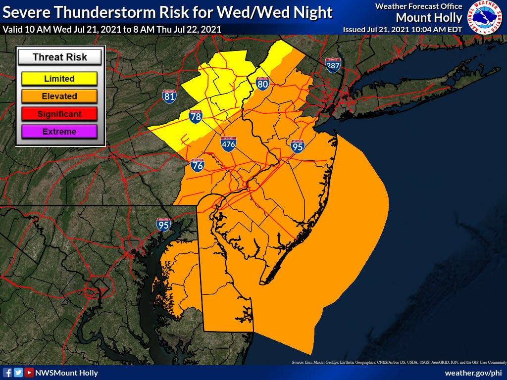
Update: The National Weather Service has issued a Severe Thunderstorm Watch through 8 p.m. in 21 New Jersey counties, including Atlantic, Bergen, Burlington, Camden, Cape May, Cumberland, Essex, Gloucester, Cumberland, Hudson, Hunterdon, Mercer, Middlesex, Monmouth, Morris, Ocean, Passaic, Salem, Somerset, Sussex, Union and Warren.
Previous story:
NEW JERSEY - Scattered severe thunderstorms are on the forecast for all 21 counties in New Jersey on Wednesday, expected to bring strong to damaging wind gusts, large hail and dangerous cloud-to-ground lightning. Flash flooding is also possible in susceptible areas.
Find out what's happening in Ocean Cityfor free with the latest updates from Patch.
The storms are predicted to hit the Garden State midday through Wednesday evening, with the most activity anticipated between 11 a.m. and 7 p.m. along and east of the I-95 corridor, according to the National Weather Service.
The severe weather will most likely hit the northeast New Jersey region first between noon to 2 p.m., while central Jersey and the shore area will see storms pick up between 1 and 3 p.m.
Find out what's happening in Ocean Cityfor free with the latest updates from Patch.
Good evening everyone,
A cold front will help scour out the smoke Wed afternoon, but it will also bring with it the potential for strong thunderstorms capable of damaging winds and large hail.
On a positive note, Thursday may be the nicest day of July! #njwx #dewx #mdwx #pawx pic.twitter.com/I2L47pBiml
— NWS Mount Holly (@NWS_MountHolly) July 21, 2021


As temperatures approach the mid-80s, heat exhaustion will be possible with prolonged exposure today, the National Weather Service said.
A Hazardous Weather Outlook was issued by the National Weather Service through Wednesday night amid the severe weather forecast. Minor coastal flooding is also possible, the agency said. Isolated flash flooding may be in the cards, but most flooding will be localized to areas that can experience rapid runoff with heavy rainfall.
Here are the affected counties:
- Atlantic
- Ocean
- Burlington
- Middlesex
- Cape May
- Monmouth
- Sussex
- Warren
- Somerset
- Mercer
- Salem
- Passaic
- Bergen
- Hudson
- Essex
- Union
- Morris
- Gloucester
- Camden
- Cumberland
- Hunterdon
Due to the smoke condition brought from wildfires impacting the west coast of the country, the New Jersey Department of Environmental Protection has also issued a code orange air quality alert Wednesday for eight counties in the state. A code orange alert is issued when air pollution concentrations within the region may become unhealthy for sensitive groups.
Populations that may be affected by the air quality include children, people suffering from asthma, heart disease or other lung diseases and the elderly.
“The effects of air pollution can be minimized by avoiding strenuous activity or exercise outdoors,” the National Weather Service said in a statement.
Here is a look at the smoke forecast through tonight. The haze should clear out behind the approaching cold front. pic.twitter.com/1WQ6I5vfNL
— NWS Mount Holly (@NWS_MountHolly) July 21, 2021
Here are the affected counties:
- Ocean
- Monmouth
- Mercer
- Burlington
- Gloucester
- Middlesex
- Camden
- Middlesex
Here’s the latest forecast:
Wednesday: Showers and thunderstorms. Some storms could be severe, with large hail, hail, damaging winds, gusty winds and heavy rain. Widespread haze before noon. High near 81. Southwest wind around 5 mph becoming northeast in the morning.
Wednesday Night: A chance of showers and thunderstorms before 8 p.m. Mostly clear, with a low around 67. Northwest wind 5 to 10 mph. Chance of precipitation is 30 percent. New precipitation amounts between a tenth and quarter of an inch, except higher amounts possible in thunderstorms.
Thursday: Mostly sunny, with a high near 80. Northwest wind 5 to 10 mph.
Thursday Night: Partly cloudy, with a low around 67. West wind around 10 mph.
Get more local news delivered straight to your inbox. Sign up for free Patch newsletters and alerts.