Weather
New Jersey Should Prepare For Hurricane Irma, State Climatologist Says
"There is enough of a threat" to New Jersey, the state's leading forecaster says.

Hurricane Irma poses "enough of a threat" to New Jersey that the state should be prepared for whatever could come its way, the state's official climatologist said. Most models show the powerful storm turning north and east after striking Florida.
David Robinson, the state's official climatologist, said the storm is acting much like Hurricane Donna in 1960, which struck Florida before bending to the north and east. By the time it got to New Jersey, it still had 110 mph winds.
"There is enough of a threat that we should be prepared," Robinson said.
Find out what's happening in Point Pleasantfor free with the latest updates from Patch.
Even if Irma doesn't directly hit New Jersey and moves inland, he said, the storm will likely have some impact on the region, and remnants of Irma could produce tropical storm gales and have other impacts on New Jersey and Pennsylvania.
"My advice is that people should read Patch and pay attention to the weather forecast," Robinson said. "It could manifest itself with strong winds. It could manifest itself in heavy rains inland."
Find out what's happening in Point Pleasantfor free with the latest updates from Patch.
Paul Daley, Toms River Office Of Emergency Management coordinator, said his office is "closely monitoring the status of Hurricane Irma."
"We have been in constant contact with our partners from Ocean County OEM, New Jersey OEM, EMS, Fire, and Police," he said. "While the track of the storm is still too far out to predict for our area, all equipment and personnel are ready for deployment should any action become necessary."
This hurricane season has become the most active in at least seven years, Robinson said. The last time there were three active hurricanes off the U.S. shores was 2010.
Watch: Deaths, Destruction Reported As Hurricane Irma Heads Toward Florida
Robinson suggested that Irma poses a bigger threat to the Northeast than Jose, which is currently about 1,000 miles to the east of Irma. Robinson believes Jose will dissipate over the ocean or turn away from the coast. Hurricane Katia, meanwhile, is headed toward the Gulf of Mexico.
Robinson said the Northeast's biggest worry would be if Irma turned to the north and east before it hit Florida. If it does, that would increase the likelihood of the storm having a major impact on the state.
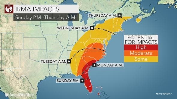
Robinson said Irma's impact on New Jersey and Pennsylvania would likely come during the Tuesday-to-Thursday time frame.
Read more: Hurricane Irma:Latest Tracks, Storm Updates, Possible New Jersey Impacts
NEW... 11am advisory from @NHC_Atlantic shows a slight move east in FL. Winds now 175 mph. #njmorningshow pic.twitter.com/IhY5S4wHiB
— Kurt Siegelin (@kurtsiegelin) September 7, 2017
AccuWeather backed up that assessment, saying Irma has the potential to be a major event for the East Coast, according to Evan Myers, AccuWeather expert senior meteorologist and chief operating officer.
“It also has the potential to significantly strain FEMA and other governmental resources occurring so quickly on the heels of Harvey,” Myers said in a release.
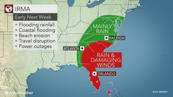
Myers said Irma is likely to move up along the east coast of Florida, Georgia and South Carolina, so people from the Florida Keys all the way to Cape Hatteras, North Carolina, should prepare to be ready to evacuate coastal areas, starting with South Florida, Myers added.
At the very least, heavy rain is forecast to spread inland toward the southern Appalachians, potentially leading to extensive flooding due to the mountainous and hilly terrain. Damaging winds will become less of a concern the farther inland Irma moves. Some of Irma's rain may reach into the mid-Atlantic and Northeast toward midweek, according to AccuWeather.
There is a low chance that Irma completely misses the United States.
YouTube video/photo
Get more local news delivered straight to your inbox. Sign up for free Patch newsletters and alerts.


