Weather
Hurricane Threat To New Jersey 'Far From Over.' Here's Why.
We may not have seen the last of major storms threatening our region.


It ain't over 'til it's over, and this year's weather hasn't always been predictable. So don't think we've seen the last of disastrous hurricanes, forecasters say.
Additional hurricanes, beyond that of Irma, Jose and Maria, are likely over the Atlantic and could threaten New Jersey and the East Coast for the rest of the 2017 season, according to an AccuWeather release.
The hurricane season runs through the end of November, and it is possible the Atlantic may continue to produce tropical storms right up to the wire and perhaps into December.
Find out what's happening in Point Pleasantfor free with the latest updates from Patch.
"I think we will have four more named storms this year, after Maria," said AccuWeather Hurricane Expert Dan Kottlowski. "Of these, three may be hurricanes and one may be a major hurricane."
The numbers include the risk of one to two additional landfalls in the United States.
Find out what's happening in Point Pleasantfor free with the latest updates from Patch.
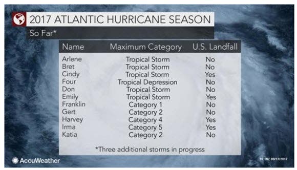
As of this week, there have been four named systems that made landfall, including Harvey and Irma that made landfall in the U.S. as Category 4 hurricanes, according to the release. The other two tropical storms were Cindy, near the Texas/Louisiana border in June, and Emily, just south of Tampa, Florida, at the end of July.
Jose impacted the coast of the northeastern U.S. much of last week; Lee and Maria are in progress over the south-central Atlantic; and Maria continues to pose a threat to bathers along the Jersey Shore. Three people died over the weekend.
Read more: 3 Dead, At Least 150 Rescued Off New Jersey As Hurricane Maria Impacts Shore
Lee will likely remain at sea and is not expected be a threat to the U.S. or any land areas.
Here's why forecasters believe hurricanes still present a threat:
- On average, strong west to northwest winds with cooler and drier air tend to scour tropical systems out of the western Atlantic during October and November.
- However, this year, AccuWeather meteorologists are concerned that these winds may not occur until later in the autumn or may be too weak to steer tropical threats away from the U.S.
- The warm weather pattern that has developed over the Central states and expanded into the eastern U.S. is a product of that development. Driving this warm weather pattern is a large area of high pressure, centered near Bermuda
- The clockwise flow around this system will pump warm, humid air northward from the Gulf of Mexico and the western Atlantic.
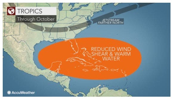
Tropical storms and hurricanes that brew will get caught up in the flow around this high-pressure area, according to the release. While interruptions in this flow and the warm and humid pattern are likely in the northeastern U.S., it will generally persist in key tropical development areas well into October.
"When we get a pattern such as this, we usually have two to three named storms in October and can have one in November or December," Kottlowski said in the release.
Patch file photo
Get more local news delivered straight to your inbox. Sign up for free Patch newsletters and alerts.


