Weather
Next Big Storm: These 37 N.J. Towns May Get Hurt The Worst, Study Says
You may be surprised to see what N.J. towns could get hurt the worst in the next big storm - and they're not just at the Jersey Shore.


You may be surprised to see what New Jersey towns could get hurt the worst in the next big storm — and they're not just at the Jersey Shore.
A report, called Under Water: How Sea Level Rise Threatens the Tri-State Region, produced by the Regional Plan Association, paints a dire picture of what New Jersey could face if the next Superstorm Sandy, big Nor'easter or even a blizzard hits the area.
Coastal regions around the world are struggling to adjust to the gradual but relentless encroachment of ocean waters, and a number of New Jersey communities could be impacted by the sea-level rise, according to the report.
Find out what's happening in Point Pleasantfor free with the latest updates from Patch.
In other words, lots of flooding could be coming to New Jersey when the next big storm hits.
New Jersey faces a severe threat from sea level rise, yet relatively little has been done to address the potential damage to infrastructure and communities.
Find out what's happening in Point Pleasantfor free with the latest updates from Patch.
This report identifies the places in the New York, New Jersey and Connecticut metropolitan area that are most at risk of being permanently flooded, and describes the effects of 1, 3 and 6 feet of sea-level rise on neighborhoods, employment centers and infrastructure.
"Taking into account the latest scientific findings on sea level rise and climate change, the study finds that many of the major resilience policies, plans and projects under development today fall short of adequately addressing the long term, existential threat of permanent flooding from sea level rise," according to the report.
Here are the towns most at-risk of flooding and other potential damage:
- Barnegat
- Barnegat Light
- Beach Haven
- Berkeley Township
- Eagleswood
- Hazlet
- Highlands
- Hoboken
- Jersey City
- Keansburg
- Kearny
- Lacey
- Little Egg Harbor
- Lavallette
- Little Ferry
- Long Beach Township
- Long Branch
- Middletown
- Manasquan
- Moonachie
- Monmouth Beach
- Ocean Gate
- Oceanport
- Perth Amboy
- Point Pleasant Beach
- Point Pleasant Boro
- Rumson
- Sea Bright
- Seaside Heights
- Seaside Park
- Secaucus
- Ship Bottom
- South River
- Surf City
- Teterboro
- Toms River
- Waretown
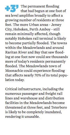
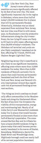
The report says New Jersey communities along the shores of the Hudson River, Arthur Kill, Hackensack, Passaic and Raritan rivers and Newark and Raritan Bay, in general are more urbanized than in other parts of New Jersey and thus have more protective infrastructure in place to minimize the flooding of one
foot of sea level rise.
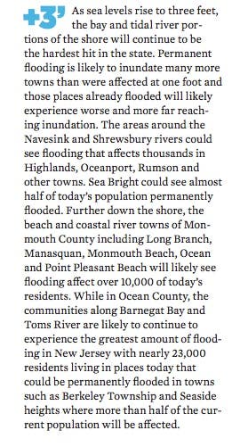
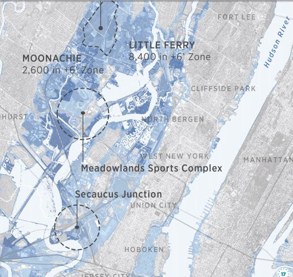
In the Hackensack Meadowlands, a few communities such as Moonachie and parts of Secaucus as well as Teterboro Airport begin to see inundation at 1 foot. Communities along the Raritan Bay and the Raritan River are more affected with more than 1,000 of today’s population facing inundation in towns like Middletown, Sayreville and Union Beach.
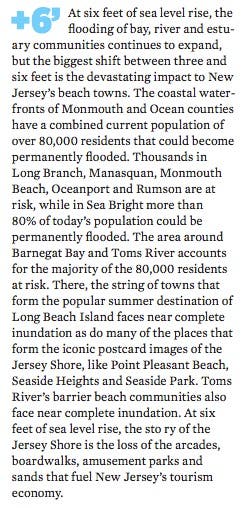
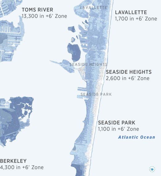
At 1 foot of sea level rise, the Jersey Shore is particularly vulnerable to permanent flooding, with much of the initial inundation in communities that line its back bays, tidal rivers and estuaries. Particularly affected are the Ocean County communities around Barnegat Bay and Toms River, where more than 3,000 of today’s residents live in places that could be inundated, according to the report.
Here's what else the report says:
Patch file photo
Get more local news delivered straight to your inbox. Sign up for free Patch newsletters and alerts.


