Weather
NJ Nor'easter: 17K Lose Power, Street Floods, 62-MPH Wind: Video
UPDATE: See which towns had strongest winds, most rain in nor'easter that roared in NJ. Video captured the towns where streets were flooded.


A nor'easter roared through much of New Jersey on Saturday, and video was capturing the scene in some towns where streets were flooded. Patch has the list of towns that lacked power – more than 17,000 at mid-day – and who was hit the worst (see below).
Some towns had winds as strong as 62 mph and had 2.4 inches of rain (see lists below).
In Princeton, Bridgewater and many other towns, downed trees and wires were blocking roads (see list of flooded highways below).
Find out what's happening in Point Pleasantfor free with the latest updates from Patch.
Long Beach Boulevard on Long Beach Island was "completely impassable," police said. Later in the day, North Jersey communities such as Bogota and Hackensack were inpacted (see videos below).
More rain was expected in some areas later Saturday and Sunday (see forecast below).
Find out what's happening in Point Pleasantfor free with the latest updates from Patch.
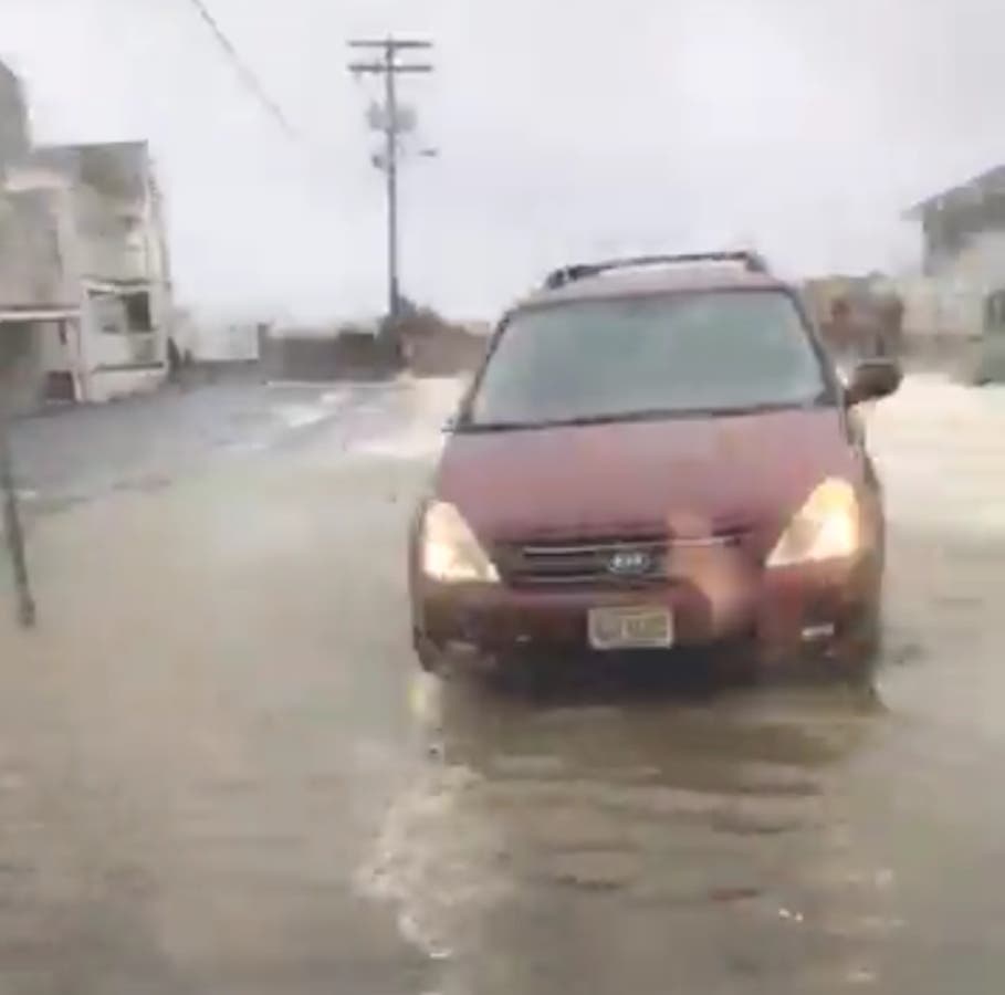
The nor'easter was strongly battering the streets and shoreline in Point Pleasant Beach and other Jersey Shore towns, where residents were wading through the high water.
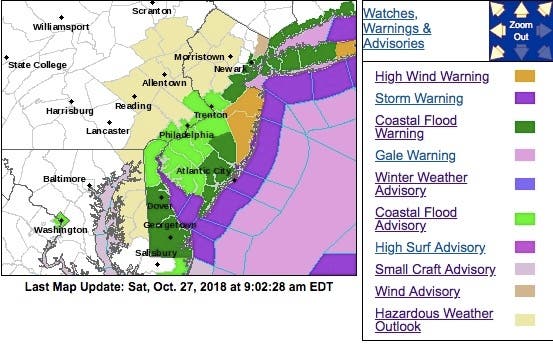
Coastal flood and high-wind warnings were in effect along the Jersey Shore, where 50-mph wind gusts were expected, and a hazardous weather outlook was in effect throughout the state.
For some places, this will likely be the highest water levels seen in several years. At this level, widespread flooding of roadways is expected with many roads becoming impassable, according to the National Weather Service.
Lives may be at risk when people put themselves in harm's way, according to the NWS. Some damage to vulnerable structures may begin to occur. In Middlesex County, minor road flooding is possible in Woodbridge Township, Perth Amboy, Old Bridge Township, and South Amboy.
Waves are 8 to 12 feet on the oceanfront.
Here were the alerted areas:
Here are the towns with the strongest winds:
- Harvey Cedars 62
- Seaside Heights 59
- Sea Girt 57
- Fortescue 50
- West Creek 47
- Berkeley Twp. 46
- Woodbine 46
- High Point Monument 45
- Wall Twp. 45
- Point Pleasant 44
- Vineland 44
- Atlantic City 43
- Mullica Twp. 43
- Oswego Lake 42
- West Cape May 42
- Upper Deerfield 41
- Cedar Bridge 39
- Cream Ridge 38
- Kingwood 37
- Oceanport 37
- Pennsauken 37
- Lower Alloways Creek Twp. 36
- Moorestown 36
- Pittstown 36
- Columbus 35
- Logan Twp. 34
- Lyndhurst 34
- Bivalve 33
- Greenwich 33
- Sicklerville 33
- Silas Little 33
- Cape May Court House 32
- Hammonton 32
- Holmdel 32
- Mannington Twp. 31
- Toms River 31
- New Brunswick 30
- Dennis Twp. 29
- Egg Harbor Twp. 29
- Hopewell Twp. 29
- Howell 29
- Mansfield 27
- West Deptford 27
- Haworth 26
- Sewell 26
- Pequest 24
- Woodstown 24
- Hillsborough 23
- Hawthorne 22
- South Harrison 22
- Stewartsville 22
- Basking Ridge 21
- Piney Hollow 21
- Charlotteburg 20
- Ramsey 20
- Hamilton 19
- Walpack 18
- Cherry Hill 17
- Hackettstown 16
Here are the towns with the most rain:
- Howell 2.43
- Holmdel 2.09
- Berkeley Twp. 1.92
- Egg Harbor Twp. 1.84
- Woodbine 1.81
- Cape May Court House 1.79
- Oceanport 1.66
- West Creek 1.63
- Wall Twp. 1.58
- Cedar Bridge 1.55
- Sea Girt 1.54
- Toms River 1.54
- Atlantic City 1.53
- Hammonton 1.46
- Sicklerville 1.34
- Harvey Cedars 1.33
- Oswego Lake 1.33
- Sewell 1.3
- West Deptford 1.23
- Dennis Twp. 1.22
- Jersey City 1.2
- Mullica Twp. 1.2
- Red Lion 1.16
- Silas Little 1.16
- Woodstown 1.15
- New Brunswick 1.13
- Lyndhurst 1.12
- Moorestown 1.12
- Cream Ridge 1.11
- Mannington Twp. 1.05
- Stewartsville 1.05
- Basking Ridge 1.03
- Logan Twp. 1.03
- Columbus 1
- Hamilton 1
- Pennsauken 0.97
- Hopewell Twp. 0.95
- Seaside Heights 0.95
- Pittstown 0.94
- Pequest 0.93
- Piney Hollow 0.93
- Cherry Hill 0.92
- Fortescue 0.91
- South Harrison 0.91
- Hawthorne 0.89
- Upper Deerfield 0.89
- West Cape May 0.88
- Kingwood 0.87
- Ramsey 0.87
- Charlotteburg 0.86
- Walpack 0.86
- Mansfield 0.85
- Wayne 0.85
- Greenwich 0.83
- Parsippany 0.81
- Haworth 0.8
- Hillsborough 0.77
- Lower Alloways Creek Twp. 0.76
- Hackettstown 0.65
- High Point Monument 0.33
Here is the forecast:
- Saturday: Patchy drizzle with a slight chance of rain. Cloudy, with a high near 55. Breezy, with a northeast wind 18 to 20 mph, with gusts as high as 34 mph. Chance of precipitation is 20%.
- Saturday night: A chance of showers, mainly before 11pm. Mostly cloudy, with a low around 43. North wind around 9 mph becoming southwest after midnight. Chance of precipitation is 40%. New precipitation amounts of less than a tenth of an inch possible.
- Sunday:A slight chance of showers after 2pm. Mostly cloudy, with a high near 56. West wind around 10 mph. Chance of precipitation is 20%.
- Sunday night: Rain likely, mainly after 2am. Mostly cloudy, with a low around 44. Southwest wind around 6 mph becoming calm in the evening. Chance of precipitation is 70%. New precipitation amounts between a tenth and quarter of an inch possible.
- Monday: Rain likely before 8am, then a chance of showers, mainly between 8am and 2pm. Cloudy, with a high near 56. Calm wind becoming west 5 to 9 mph in the afternoon. Chance of precipitation is 60%. New precipitation amounts of less than a tenth of an inch possible.
Here are the towns who had residents who lost power:
- BRICK TOWNSHIP 1,879
- JACKSON TOWNSHIP 1,367
- MILLSTONE TOWNSHIP 1,330
- MIDDLETOWN TOWNSHIP 1,066
- SHREWSBURY BOROUGH 834
- LAKEWOOD TOWNSHIP 762
- OCEAN TOWNSHIP 691
- MANALAPAN TOWNSHIP 660
- NEPTUNE TOWNSHIP 647
- ASBURY PARK CITY 637
- MONROE TOWNSHIP 618
- TOMS RIVER TOWNSHIP 535
- SUMMIT CITY 382
- LACEY TOWNSHIP 371
- NEWARK CITY 365
- HOLMDEL TOWNSHIP 357
- HAMPTON TOWNSHIP 314
- RUMSON BOROUGH 274
- LAFAYETTE TOWNSHIP 261
- WEST LONG BRANCH BOROUGH 260
- UPPER FREEHOLD TOWNSHIP 251
- EATONTOWN BOROUGH 233
- WALL TOWNSHIP 227
- SPARTA TOWNSHIP 199
- UNION TOWNSHIP 191
- OCEAN TOWNSHIP 181
- FRANKFORD TOWNSHIP 146
- Bass River Twp 137
- MARLBORO TOWNSHIP 128
- FAIR HAVEN BOROUGH 118
- OLD BRIDGE TOWNSHIP 112
- BELMAR BOROUGH 102
- PEMBERTON TOWNSHIP 101
- TINTON FALLS BOROUGH 98
- Maurice River Twp 92
- PHILLIPSBURG TOWN 88
- Galloway Twp 85
- CLINTON TOWNSHIP 67
- TEWKSBURY TOWNSHIP 64
- KNOWLTON TOWNSHIP 59
- HOWELL TOWNSHIP 58
- FRANKLIN TOWNSHIP 54
- HOPEWELL TOWNSHIP 46
- POINT PLEASANT BOROUGH 42
- LEBANON TOWNSHIP 41
- Bridgeton City 38
- BRIELLE BOROUGH 36
- ROBBINSVILLE TOWNSHIP 35
- ABERDEEN TOWNSHIP 31
- Sea Isle City 30
- RED BANK BOROUGH 27
- Pleasantville City 26
- DELAWARE TOWNSHIP 25
- Absecon City 24
- Hopewell Twp 24
- ENGLISHTOWN BOROUGH 23
- MANCHESTER TOWNSHIP 20
- Egg Harbor City 20
- FREEHOLD TOWNSHIP 19
- Franklin Twp 19
- Upper Twp 18
- RARITAN TOWNSHIP 17
- Monroe Twp 17
- LONG BRANCH CITY 14
- MANASQUAN BOROUGH 14
- ALEXANDRIA TOWNSHIP 13
- SHREWSBURY TOWNSHIP 13
- Hamilton Twp 13
- MATAWAN BOROUGH 10
- BEACHWOOD BOROUGH 9
- FREDON TOWNSHIP 8
- Stafford Twp 8
- EAST AMWELL TOWNSHIP 7
- HARDYSTON TOWNSHIP 7
- NEPTUNE CITY BOROUGH 5
- Mullica Twp 5
Here is a list of other flooded highways.
Saturday afternoon:
- NJ 7: Flooding on NJ 7 westbound South of CR 507/Schuyler Av in Kearny. All lanes closed and detoured; 5-10 minute delay.
- NJ 3: Flooding on NJ 3 service road eastbound area of Meadowlands Sports Complex in East Rutherford. Partial ramp closed.
- NJ 35: Flooding on NJ 35 northbound south of NJ 71/H Street in Belmar. Right lane closed.
- NJ 17: Flooding on NJ 17 in both directions north of East Union Av in East Rutherford. One lane open to traffic 5-10 minute delay.
- NJ 7: Flooding on NJ 7 westbound south of CR 507/Schuyler Av in Kearny. 1 to 2 lanes closed.
- NJ 152: Flooding on NJ 152 in both directions west of CR 619/To Ocean Dr in Egg Harbor Twp. All lanes closed.
- NJ 35: Flooding on NJ 35 in both directions between CR 689/Lawrence Pkwy in Old Bridge Twp and North of Morgan Drawbridge in Sayreville. All lanes closed and detoured.
- NJ 147: Flooding on NJ 147 in both directions at Maryland Av in Middle Twp. All lanes closed and detoured.
- NJ 47: Flooding on NJ 47 in both directions CR 624/West Rio Grand Ave in Wildwood. All lanes closed and detoured.
- US 30L looding on US 30 westbound from west of Atlantic City Expressway/Indiana Av in Atlantic City to CR 585/NJ 157 in Absecon City. All lanes closed.
- US 30: Flooding on US 30 in both directions between east of CR 674/Berman Av and East of CR 563/Tilton Rd in Galloway Twp all jughandles closed.
Saturday morning:
- NJ 7: Flooding on NJ 7 southbound in the vicinity of CR 659/Fish House Rd in Kearny. One lane closed.
- NJ 47 : Flooding on NJ 47 in both directions CR 624/West Rio Grand Ave in Wildwood. All lanes closed and detoured.
- NJ 47: Downed tree and Downed wires and a Utility Pole Down on NJ 47 in both directions North of CR 616/Blade Rd in Maurice River Twp. All lanes closed and detoured.
- US 30: Flooding on US 30 westbound from West of Atlantic City Expressway/Indiana Av in Atlantic City to CR 585/NJ 157 in Absecon City. All lanes closed.
- NJ 147: Flooding on NJ 147 in both directions at Maryland Av in Middle Twp. All lanes closed and detoured.
- US 30: Flooding on US 30 in both directions between East of CR 674/Berman Av and East of CR 563/Tilton Rd in Galloway Twp all jughandles closed.
- US 30: Flooding on US 30 westbound from East of CR 674/Berman Av to CR 614/Cologne Av in Galloway Twp. Right lane closed.
- NJ 35: Flooding on NJ 35 northbound south of NJ 71/H Street in Belmar. Right lane closed.
- NJ 50: Downed tree and downed wires on NJ 50 in both directions South of Gibson Creek Rd in Estell Manor. All lanes closed.
- Garden State Parkway: Accident on the Garden State Parkway southbound Exit 142-A - I-78 East in Hillside Twp. Left lane blocked.
- I-295: Accident on I-295 northbound area of Exit 29 - US 30 in Barrington. Right lane closed.
- Garden State Parkway: Accident on the Garden State Parkway local lanes southbound North of Exit 109 - CR 520 in Middletown Twp. 2 left lanes blocked.
- I-295: Accident on I-295 southbound at Exit 26S - NJ 42/I-76/I-676 in Bellmawr. Right lane closed.
- Garden State Parkway: Accident on the Garden State Parkway northbound South of Driscoll Bridge in Sayreville. 1 lane blocked.
- Garden State Parkway: Accident on the Garden State Parkway local lanes northbound south of Exit 117 - NJ 36 in Hazlet Twp. Right lane blocked.
- US 46: Street light knockdown on US 46 westbound East of CR 625/Randolph Av in Clifton. Right lane closed.
- NJ 18: Accident and a traffic signal down on NJ 18 in both directions North of CR 617/Rues Ln in East Brunswick Twp. Left lane closed for repairs.
More photos and video:
Point Pleasant Beach
Long Branch
Wake up to. Whipping wind on the JerseyShore in Long Branch @NBCNewYork @StormTeam4NY @JSHurricaneNews @belmardays @gothamwhale @Scott__Shanker @DinaLongSB pic.twitter.com/UgN5K2I8qn
— Brian Thompson (@brian4NY) October 27, 2018
Hoboken
Hoboken Terminal. #noreaster #hoboken pic.twitter.com/s2e7tcrgDY
— Don't Sit Home® (@dontsithome) October 27, 2018
Monmouth Beach
Atlantic Ocean doing battering seawall in Monmouth Beach @StormTeam4NY @Scott__Shanker @NBCNewYork @JSHurricaneNews @belmardays @DinaLongSB pic.twitter.com/OrV5ozXCEH
— Brian Thompson (@brian4NY) October 27, 2018
Long Beach Island
As predicted by @NWS_MountHolly we are experiencing Costal Flooding on @LBI. Bay high tide was at 11:18AM, rain has stopped and winds are calming down. If you need to travel be aware the LBI Blvd. is flooded, use Beach Ave and drive carefully! pic.twitter.com/BDnEw9I1c4
— LBIWeather.com (@LBIWeather) October 27, 2018
Barnegat
Tree and live wires down. Lower Shore Road. Please avoid the area. @brian4NY @tedgreenbergNBC #Noreaster pic.twitter.com/AJLhUTsVin
— Chief Keith Germain (@BTPD318) October 27, 2018
Sea Bright
Major flooding on streets in Sea Bright....this is Warren St...yes we played it safe as always and turned the truck around @ABC7NY @AmyFreeze7 #noreaster #nywx #njwx pic.twitter.com/RRARxHLDZ6
— Naveen Dhaliwal (@NaveenDhaliwal) October 27, 2018
Stone Harbor
High tide at Nuns Beach this morning! #StoneHarborNJ #Noreaster pic.twitter.com/Uq01eeicGZ
— Zeke Orzech (@Zeke_O) October 27, 2018
Atlantic City
Flooding in Atlantic City @NBCPhiladelphia pic.twitter.com/nHI0WGzn2y
— Drew Smith (@drewsmithtv) October 27, 2018
Bay Head
Belmar
Flooding in Belmar, NJ @weatherchannel @News12NJ #noreaster pic.twitter.com/YfmH44ZJTy
— Jake Fradkin (@jsftennis) October 27, 2018
Bogota
The Bogota Police have issued the following road closure. Advisory WEST FORT LEE ROAD HAS BEEN CLOSED DUE TO FLOODING. PLEASE SEEK ALTERNATE ROUTE. pic.twitter.com/9zwBcaxnzU
— Bogota Blog NJ (@bogotablognj) October 27, 2018
North Wildwood
Neptune
The East End Ave bridge is closed due to flooding. Use an alternate route. #NeptuneTraffic pic.twitter.com/jUJ6fo2NVE
— Neptune Township PD (@NeptunePolice) October 27, 2018
Sea Isle City
@FOX29philly #seaislecity pic.twitter.com/Rj0sO4LQG6
— Sarah Gattis (@sarahs_potato) October 27, 2018
Deanna Jividen photos and videos
Get more local news delivered straight to your inbox. Sign up for free Patch newsletters and alerts.