Weather
NJ Weather: Hazardous Weather Outlook Issued For Thunderstorms, Hail Tuesday
It could be a nasty Tuesday across New Jersey, with thunderstorms, heavy rain and even hail.


It could get nasty Tuesday. The National Weather Service has issued a hazardous weather outlook through most of New Jersey, saying thunderstorms are possible and could bring heavy rain and even hail.
By 9:15 a.m., it was already raining heavily during thunderstorms in some parts of New Jersey. Only Bergen, Passaic, Hudson and Essex counties did not receive the NWS alert.
Here are the alerted areas:
Find out what's happening in Point Pleasantfor free with the latest updates from Patch.
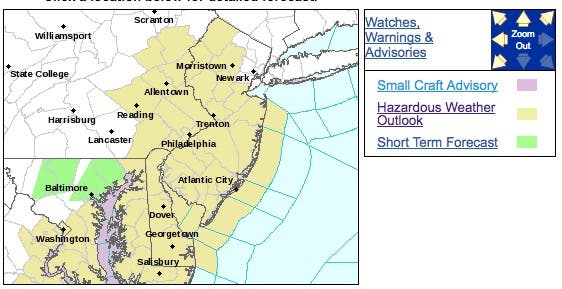
According to the hazardous weather outlook, "thunderstorms may produce small hail and brief, poor drainage flooding rain today, mainly along and southeast of the Interstate 95 corridor."
The storms should clear out by late afternoon, but showers could continue through the day.
Find out what's happening in Point Pleasantfor free with the latest updates from Patch.
Once the rain stops, expect patchy fog throughout Tuesday night. Things should clear up by Wednesday, when a high in the 60s is expected.
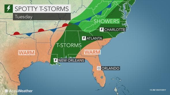
The storms are supposed to wreak havoc in the South first before moving to the New Jersey area.
Here is the forecast:
Wednesday: Mostly cloudy through mid morning, then gradual clearing, with a high near 60. North wind 9 to 11 mph.
Wednesday Night: Mostly clear, with a low around 35. North wind 6 to 9 mph.
Thursday: Sunny, with a high near 55. North wind around 5 mph becoming calm in the morning.
Thursday Night: A chance of rain, mainly after 2am. Mostly cloudy, with a low around 39. Chance of precipitation is 30%.
Friday: Rain, mainly after 8am. High near 51. Chance of precipitation is 80 percent.
Friday Night: Rain. Low around 43. Chance of precipitation is 80 percent.
Patch file photo
Get more local news delivered straight to your inbox. Sign up for free Patch newsletters and alerts.


