Weather
NJ Weather: Hurricane Florence Remnants Timeline, Rainfall Totals
What was Hurricane Florence is now a tropical depression. Here's what that means, and what to expect in New Jersey.


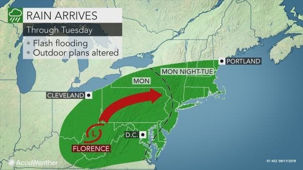
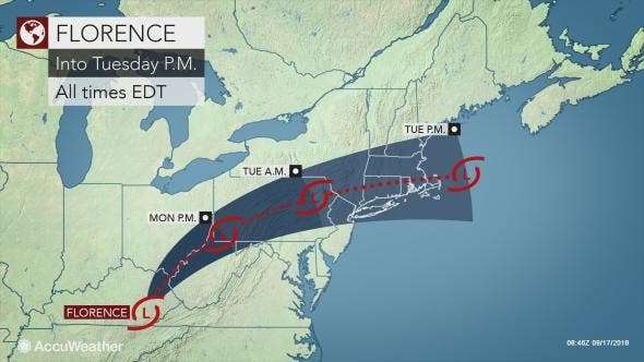
Expect heavy rainfall and possible flooding as the remnants of Hurricane Florence are expected to arrive later Monday and last into Tuesday.
The storm could be capable of producing between 3 to 5 inches of rain and, possibly, strong winds, resulting in a significant threat of flash flooding, according to the National Weather Service.
Rip currents could be a problem up and down the Jersey Shore. Three people died in rough New Jersey waters this weekend. Read more: At Least 30 NJ Water Deaths Since May After Weekend Tragedy
Find out what's happening in Point Pleasantfor free with the latest updates from Patch.
The storm is now considered a tropical depression, which means that it's capable of producing winds up to 39 mph but doesn't pack the punch of a hurricane or tropical storm. The NWS has issued a hazardous weather outlook for all New Jersey (see forecast and timeline below).
Here is what to expect:
Find out what's happening in Point Pleasantfor free with the latest updates from Patch.
- Rain is supposed to arrive after 2 p.m. on Monday, dropping less than a tenth of an inch of rain before 8 p.m.
- The rain is expected to fall a little harder, with another tenth of inch expected to fall between 8 p.m. and 2 a.m.
- The heaviest rain is expected to come between 2 a.m. and 2 p.m. on Tueaday, when at least an inch is expected to fall.
- Thunder is possible after 4 p.m. on Monday, but is much more likely after 8 a.m, on Tuesday.
Towns and cities such as Newark have advised drivers to avoid getting stranded, and not do things such as driving through flooded streets and high water. Avoid these locations and to use alternative routes.
Drivers are also discouraged from traveling through any streets that are flooded, have high water or are believed to be flooded.
"Localized flooding issues may also occur along the I-95 corridor from Washington, D.C., to Boston and west of the Appalachian Mountains from Huntington, West Virginia, to Erie, Pennsylvania," AccuWeather Senior Meteorologist Kristina Pydynowski said in a release.
AccuWeather meteorologists cannot rule out the potential for a brief tornado to spin up to the southeast of Florence’s center, according to the release. This risk will be highest from parts of North Carolina to Virginia and Maryland on Monday.
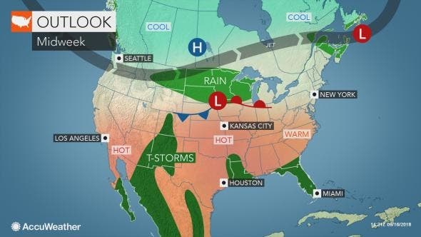
“After Florence departs, high pressure building down from the northwest will bring a much more refreshing air mass into the Northeast on Wednesday,” Elliott said in the release. Humidity levels will be slashed and sunshine will return, making for great weather to head outdoors or open up the windows.
- Monday: A slight chance of showers. Mostly cloudy, with a high near 80. South wind 3 to 7 mph. Chance of precipitation is 20%.
- Monday night: A chance of showers and thunderstorms, then showers likely and possibly a thunderstorm after 5am. Some of the storms could produce heavy rain. Cloudy, with a low around 71. South wind 5 to 7 mph. Chance of precipitation is 60%. New rainfall amounts of less than a tenth of an inch, except higher amounts possible in thunderstorms.
- Tuesday: Showers and possibly a thunderstorm. Some of the storms could produce heavy rain. High near 81. Southwest wind 6 to 9 mph. Chance of precipitation is 90%. New rainfall amounts between a half and three quarters of an inch possible.
- Tuesday night: A chance of showers, mainly before 11pm. Cloudy, then gradually becoming partly cloudy, with a low around 68. North wind 5 to 8 mph. Chance of precipitation is 50%. New precipitation amounts between a quarter and half of an inch possible.
- Wednesday: Mostly sunny, with a high near 77. Northeast wind 5 to 7 mph.
Tom Davis photo
Get more local news delivered straight to your inbox. Sign up for free Patch newsletters and alerts.