Weather
NJ Weather: Gov. Phil Murphy To Address Snowstorm (WATCH LIVE)
WATCH LIVE: Gov. Phil Murphy will address storm operations just as travel restrictions were issued on NJ highways.


NEW JERSEY – A winter storm warning and snow alerts have expanded to 17 New Jersey counties as the National Weather Service says more of the state may be impacted by a Monday storm packing nearly a foot of snow. Commercial travel restrictions were in place as the snow was piling on major roads (see expected snow totals below).
Gov. Phil Murphy was set to address the storm operations at 11 a.m. on Monday. Watch live here:
The National Weather Service has released its estimations of snow, wind, rain and temperatures for the storm, broken down county-by-county. Read more: NJ Weather: Timeline, Hour-By-Hour Forecast Of NJ Snowstorm
Find out what's happening in Point Pleasantfor free with the latest updates from Patch.
State offices will close at 12 noon on Monday.
Enough snow – 8 to 12 inches in spots – could fall to close schools or delay openings. Hundreds of schools were already closed even though the bulk of the snow is expected to hit between 8 a.m. and 6 p.m. on Monday. Read more: New Jersey School Closings/Delays/Dismissals List For Monday and Tuesday.
Find out what's happening in Point Pleasantfor free with the latest updates from Patch.
Patch will also keep track of the snow totals for New Jersey towns. Read more: New Jersey Snow Totals, Town-By-Town, For Sunday, Monday And Tuesday
Already, the snow and ice was causing travel problems and crashes on New Jersey roads. A major accident – a tractor trailer rolled over – shut down I-80 westbound on Sunday, which later reopened (see list of road conditions below).
Hundreds of flights were cancelled at Newark and other airports, and traffic was jammed on major roads.
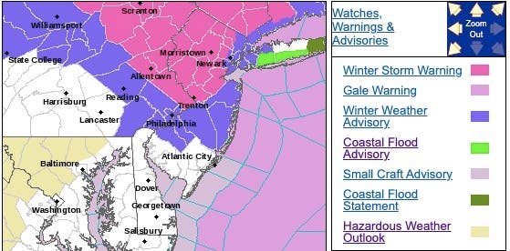
A winter storm warning was issued for Bergen, Passaic, Sussex, Morris, Warren, Middlesex and Mercer counties. The warning was set to expire between 4 and 7 a.m. on Tuesday.
A winter weather advisory, which will expire between 4 and 7 a.m. on Tuesday, was also issued for Monmouth, Ocean, Burlington, Camden, Gloucester, Hudson, Essex, Union, Somerset, Mercer and Hunterdon counties.
A coastal flood advisory was also in effect in Ocean and Monmouth counties until 4 p.m. on Monday. Here are the alerted areas:
A commercial vehicle travel restriction on portions of I-78, I-80, and I-287 was issued beginning at 12 midnight on Monday. The restriction applies to the entire length of all interstate highways in New Jersey including:
- Interstate 80, both directions from the Pennsylvania state line to Exit 43 (I-287)
- Interstate 78, both directions from the Pennsylvania state line to Exit 29 (I-287)
- Interstate 287, both directions from Exit 21 (I-78) to the New York border
The commercial vehicle travel restriction in New Jersey applies to the following vehicles:
- All tractor-trailers
- Empty straight CDL-weighted trucks
- Passenger vehicles pulling trailers
- Recreational vehicles
- Motorcycles
The restriction DOES NOT apply to:
- New Jersey Turnpike
- Garden State Parkway
- Atlantic City Expressway
The Department of Transportation is reminding motorists:
- Avoid unnecessary travel during the storm
- Consider telecommuting on Monday, if possible
- If you must drive and road conditions deteriorate, GET OFF THE ROAD somewhere safe and wait it out
- Always STAY CLEAR of plows and spreading trucks. If they are behind you, let them pass
- DO NOT PASS between trucks that are in a plow formation
- Be patient and use caution
Murphy, speaking during a Sunday press conference, stopped short of issuing an emergency declaration but said the state is "closely monitoring" the system since Thanksgiving weekend travel could be heavy (watch press conference below).
The State Police said it has deployed much heavier patrols on the roads, and Murphy said ice and sleet on Sunday and snow on Monday could lead to power outages. The governor said brine trucks have been out on state highways for days.
Murphy recalled a storm that slammed New Jersey in November 2018 that made him the target of criticism because of his underwhelming response, adding: "We are committed to not letting that happen again."
"This storm will bing a wintry mix and significant accumulations," Murphy said. "We know the forecast can change quickly with a storm like this so we are monitoring it quickly."
Here is what you should expect:
- Total snow accumulations of 5 to 9 inches – a slight tick downward from the original prediction of 5 to 11 inches – and ice accumulations of up to one-tenth of an inch are possible.
- The bulk of the snow in North Jersey is expected to fall between 8 a.m. and 6 p.m. on Monday.
- Rain is expected to change to snow by-mid-day Monday in Central Jersey, South Jersey and the Jersey Shore. As many as 2 to 4 inches may fall.
- Untreated surfaces may become hazardous, with the most travel impacts along and north of I-78
- Travel could be very difficult throughout this period. The hazardous conditions could impact holiday return travel on Sunday and the commute periods on Monday.
Here are the expected snow totals, which have grown since Saturday morning:
.png)
.png)
Here is the high-end prediction:
.png)
.png)
Here is the estimated ice accumulation:


Here are the road conditions:
- Speed restriction on the New Jersey Turnpike in both directions from North of Interchange 3 - NJ 168 in Barrington to North of Interchange 7A - I-195 in Robbinsville 45 mph for salting operations.
- Weather related issues on the Garden State Parkway in both directions from South of Exit 143C - NJ 124 in Irvington Twp to New York State Line in Montvale.
- Speed restriction on the New Jersey Turnpike - Pennsylvania Ext. in both directions from Delaware River Bridge in Burlington Twp to New Jersey Turnpike North in Mansfield Twp Speed reduced to 45 MPH for Salting Operations.
- Speed restriction on the New Jersey Turnpike in both directions from North of Interchange 14 - I-78/US 1&9 in Newark to George Washington Bridge Lower Level in Fort Lee 45 mph for salting operations.
- Vehicle off the roadway on NJ 55 southbound South of Exit 53 - Woodbury Glassboro Rd in Mantua Twp. 1 lane may be closed; use caution.
- Crash on the Garden State Parkway southbound North of Exit 81 - CR 549/Lakehurst Rd in Toms River Twp. All lanes open to traffic.
- Crash on the Atlantic City Expressway eastbound at East of Exit 28 - NJ 54 in Hamilton Twp. Left lane closed MOVE OVER FOR EMERGENCY WORKERS.
- Crash on NJ 37 eastbound ramp from southbound Garden State Parkway in Toms River Twp. Partial ramp blocked use caution, 5-10 minute delay.
- Crash on the New Jersey Turnpike northbound Inner and Outer Roadway Split in Mansfield Twp. Right lane and shoulder blocked.
- Vehicle spun out on I-287 northbound South of Exit 52 - NJ 23 in Kinnelon. Left lane blocked.
- Crash and a jack-knifed tractor trailer on I-287 southbound south of Exit 52 - NJ 23 in Kinnelon. All lanes closed 10 minute delay.
- Crash and a vehicle off the roadway on the Garden State Parkway southbound South of Exit 69 - CR 532/Waretown Rd in Ocean Twp. Left lane and shoulder blocked.
- Crash and a vehicle off the roadway on the Garden State Parkway southbound south of Exit 69 - CR 532/Waretown Rd in Ocean Twp. Left lane and shoulder blocked.
- Crash on the New Jersey Turnpike at Interchange 9 - NJ 18 in East Brunswick Twp. 1 lane blocked.
- Vehicle off the roadway on the New Jersey Turnpike inner roadway northbound exiting at Interchange 11 - Garden State Parkway in Woodbridge Twp. All lanes open to traffic.
- Truck restrictions on I-287 in both directions from Exit 21 - I-78 in Bedminster Twp to New York State Line in Mahwah Twp.
- Truck restrictions on I-80 in both directions from I-80 Toll Bridge in Hardwick Twp to Exit 43 - I-287 in Parsippany-Troy Hills Twp.
- Truck restrictions on I-78 in both directions from I-78 Toll Bridge in Phillipsburg to Exit 29 - I-287/US 202/US 206 in Bedminster Twp.
- Disabled vehicle on the New Jersey Turnpike - Eastern Spur inner roadway northbound North of Southern Mixing Bowl in Newark. Right shoulder blocked.
- Speed restriction and truck restrictions on I-80 approaching I-80 Toll Bridge in Hardwick Twp In Pennsylvania State, due to Winter Storm Ezekiel. "No Empties or Double Trailers" on I-80 Eastbound from I-81 to NJ State Line., until further notice.
- Disabled vehicle on I-295 northbound South of Exit 25 - NJ 47/Delsea Dr in Westville. Right lane closed; use caution.
- Crash on I-76 eastbound West of Exit 1B - I-295 in Gloucester City. 2 left lanes closed 10-15 minute delay, use caution.
- Crash on I-295 southbound at Exit 26S - NJ 42/I-76/I-676 in Bellmawr. Right shoulder closed use caution.
- Truck restrictions on I-287 in both directions from Exit 21 - I-78 in Bedminster Twp to New York State Line in Mahwah Twp.
- Truck restrictions on I-80 in both directions from I-80 Toll Bridge in Hardwick Twp to Exit 43 - I-287 in Parsippany-Troy Hills Twp.
- Truck restrictions on I-78 in both directions from I-78 Toll Bridge in Phillipsburg to Exit 29 - I-287/US 202/US 206 in Bedminster Twp.
- Crash on the New Jersey Turnpike - Eastern Spur northbound North of Interchange 15W - I-280 in Kearny. Right shoulder blocked.
- Crash on US 22 westbound at East of Weequahic Park in Newark. Right lane closed.
- Traffic signal down on NJ 28 in both directions West of CR 616A/Galloping Hill Rd in Roselle Park. Left turn lane closed use caution.
- Speed restriction and Truck restrictions on I-80 approaching I-80 Toll Bridge in Hardwick Twp In Pennsylvania State, due to Winter Storm Ezekiel. "No Empties or Double Trailers" on I-80 Eastbound from I-81 to NJ State Line., until further notice.
The troublesome combination of heavy rain, ice, snow and strong winds may hamper travelers during their Monday commute, since the major storm will add to travel stress on the roads and at the airports, according to AccuWeather.
Forecasters are calling it a double-barreled storm that will first spread rain, ice and snow into the northeastern United States, according to AccuWeather.
During Monday, cold air is likely to collapse toward the mid-Atlantic and southern New England coast to bring a change to accumulating snow, according to AccuWeather.
While an accumulation of a coating to an inch or so is possible around Philadelphia, up to a few inches may fall on New Jersey and the New York City area with several inches likely around Boston, according to AccuWeather. Much heavier snow is likely in the northern and western suburbs of New York City and Boston.
Should the storm strengthen a bit more, heavy snow may fall right in New York City and North Jersey and a few inches might occur in Philadelphia on Monday, according to AccuWeather. Boston could pick up a foot of snow in such a case where rain does not hold back the accumulation.
Those with flights into or out of the region on Monday, especially from Philadelphia, Newark, New York City and Boston, should expect delays and be prepared for flight cancellations, according to AccuWeather.

Here's the forecast:
- Monday: Rain, snow, and/or sleet before 1pm, then rain and/or snow between 1pm and 4pm, then snow likely after 4pm. High near 38. North wind around 11 mph. Chance of precipitation is 90%. New snow and sleet accumulation of less than a half inch possible.
- Monday night: Snow (or rain in the south) possible, mainly before 11pm, then a chance of snow showers after 2am. Cloudy, with a low around 30. North wind 10 to 13 mph. Chance of precipitation is 70%. New snow accumulation of less than one inch possible.
- Tuesday: A chance of snow showers before 8am. Partly sunny, with a high near 40. Northwest wind 10 to 13 mph. Chance of precipitation is 30%. New snow accumulation of less than a half inch possible.
Here is Murphy's press conference:
Important tips to remember when preparing for winter weather:
- Be prepared! Visit ready.nj.gov for information on how to prepare for: home, work, and your vehicle. Have an emergency kit/go-bag for all three locations.
- Pets are family too! Remember to include them in your emergency plans. Visit animalemergency.nj.gov to find out more.
- NEVER use a generator inside homes, garages, crawlspaces, sheds, or similar areas, even when using fans or opening doors and windows for ventilation. Deadly levels of carbon monoxide can quickly build up in these areas and can linger for hours, even after the generator has shut off.
- Test smoke and carbon monoxide detectors to make sure they are working before a storm.
- Know how to report a power outage to your utility company.
- Have cash on hand. If the power is out, so are the ATMs and credit card machines.
- Charge your cell phones and try not to use them if the power goes out. Texting uses less power than a phone call, so send text messages to save power if possible.
- Be sure to keep an adequate amount of gas in your car.
- Be sure to check on friends and neighbors who have access or functional needs.
- Need a warming center? Call NJ 2-1-1 or visit www.nj211.org to get connected!
- Be sure to have extra medications on hand and keep them in a water-resistant container.
- Get all of your vital records and insurance papers together now. Keep them in a water-resistant container. If you can, scan and email them to yourself so you have a copy of important numbers and policies.
- Discuss business continuity plans now. Whether you are the boss or report to a boss, discuss your game plan for continued business operations.
Here are a few tips if you must drive during or after winter weather:
- Check 511nj.org for traffic updates before you hit the road.
- Be sure to have a full tank of gas before you start your trip.
- Follow directions from local officials.
- Take it slow!
- Don’t crowd the plow! Give them plenty of room to work and never pass a snow plow on the right.
- Keep a winter weather kit in your car, containing an ice scraper, blanket, flashlight with extra batteries, bag of kitty litter, shovel and charged cell phone, as well as reflective triangles or flares, cloth or paper towels and jumper cables.
Patch Deals: Stay Warm With These Cold-Weather Essentials — Rechargeable hand warmers, heated jackets, cozy socks and more must-haves to keep you toasty:
Get more local news delivered straight to your inbox. Sign up for free Patch newsletters and alerts.


