Weather
Very Rainy May In NJ; Will June Be Better?
Find out how much rain fell in New Jersey in May — because it was among the highest ever.

In May, New Jerseyans got soaked. Indeed, some locations in New Jersey are already on pace for a top-five wettest May on record, according to the Weather Channel.
But the weather should get better as the month of June begins on Thursday. Expect sunnier days ahead.
Through Tuesday, Atlantic City had nine straight days with at least a trace of rain. All three major airports in North Jersey and New York City — JFK, LaGuardia and Newark — were on pace through May 29 for the wettest May ever.
Find out what's happening in Point Pleasantfor free with the latest updates from Patch.
Atlantic City had 7.52 inches of rain, nearly double its average May precipitation and nearly as much as its record of 8.80 inches in 1948, according to The Weather Channel and the National Weather Service.
"There was above normal precipitation, by about an inch or two, in other locations throughout the state," according to Mitchell Gaines, a National Weather Service meteorologist.
Find out what's happening in Point Pleasantfor free with the latest updates from Patch.
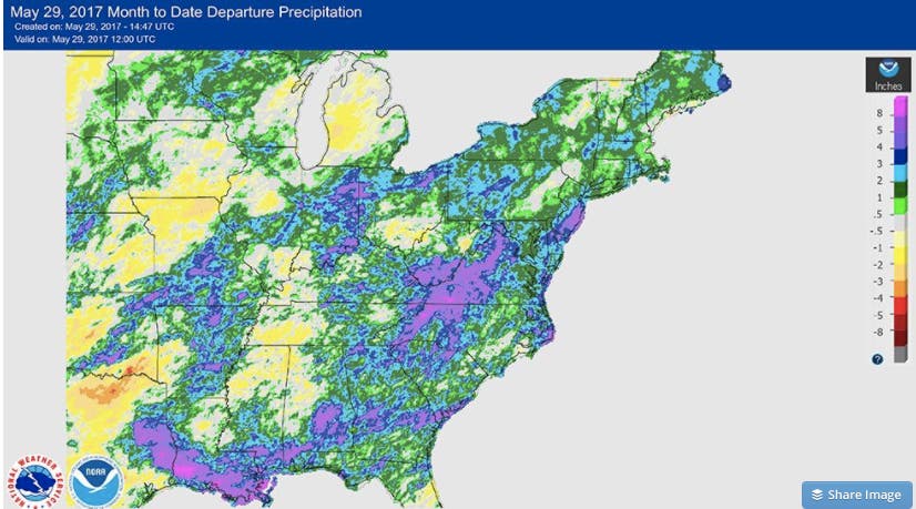
This National Weather Service map shows that rain was especially heavy in southern New Jersey:
And it could have been worse, The Weather Channel says, if it weren't for a 90-degree heat wave that roasted the region for three straight days from May 17 through 19.
The Weather Channel says the waterlogged month was because of a jet stream that repeatedly camped out over the eastern half of the U.S. in May.
As a result, New Jersey either had a deluge of heavy rain with a tropical moisture connection, or it had showers, dropping just enough rain to dampen an afternoon picnic or hike, according to The Weather Channel.
"We've had a winter weather pattern for the month of May," Gaines said.
Gaines said June should be better and the month will be more "summer-like" and offer more days of sunshine.
The Weather Channel, however, noted the changes won't happen right away.
"There will still be upper-level blocking high pressure to the north, which will keep the southward plunge of the jet stream generally over the East the rest of this week into next week, as well," according to The Weather Channel.
Here is the forecast through Friday:
- This Afternoon: A slight chance of showers and thunderstorms. Mostly sunny, with a high near 77. Calm wind becoming southwest around 5 mph. Chance of precipitation is 20%.
- Tonight: A chance of showers and thunderstorms, mainly between 7pm and 11pm. Patchy fog after 2am. Otherwise, partly cloudy, with a low around 60. South wind around 6 mph. Chance of precipitation is 30%. New rainfall amounts of less than a tenth of an inch, except higher amounts possible in thunderstorms.
- Thursday: Patchy fog before 8am. Otherwise, sunny, with a high near 81. West wind 6 to 14 mph.
- Thursday Night: Mostly clear, with a low around 53. West wind 5 to 8 mph.
- Friday: A chance of showers and thunderstorms after 2pm. Mostly sunny, with a high near 79. Light southwest wind becoming west 6 to 11 mph in the morning. Winds could gust as high as 21 mph. Chance of precipitation is 30%. New rainfall amounts of less than a tenth of an inch, except higher amounts possible in thunderstorms.
- Friday Night: A chance of showers and thunderstorms. Mostly cloudy, with a low around 60. Chance of precipitation is 40%. New rainfall amounts of less than a tenth of an inch, except higher amounts possible in thunderstorms.
NWS photo
Get more local news delivered straight to your inbox. Sign up for free Patch newsletters and alerts.


