Weather
NJ Weather: Stormy First Week Of Fall As Severe Weather Expected
Thunderstorms with damaging winds and heavy rain are possible, according to the National Weather Service. Here's when and where.


It may not look that way now, but New Jersey is supposed to have one of its stormiest weeks in a while. So you may have to put off those plans for apple picking during the first week of fall.
The National Weather Service has issued a hazardous weather outlook for most of the state, saying heavy rain may lead to localized flooding, especially in poor drainage areas, on Tuesday. Thunderstorms with damaging winds and heavy rain are possible on Wednesday.
Some rain is possible on Monday evening after 8 p.m. The heaviest rain could come after 12 noon on Tuesday. A coastal flood advisory has been issued for the Jersey Shore.
Find out what's happening in Point Pleasantfor free with the latest updates from Patch.
Here are the alerted areas:
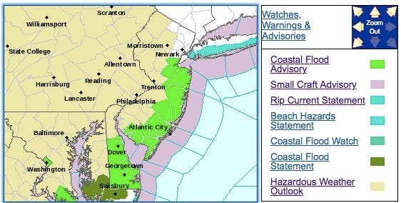
Minor roadway flooding is possible for coastal locations in Monmouth County, according to the National Weather Service. In Middlesex County, ,inor road flooding is possible in Woodbridge Township, Perth Amboy, Old Bridge Township, and South Amboy.
Find out what's happening in Point Pleasantfor free with the latest updates from Patch.
Minor roadway flooding also is possible on Long Beach Island, Seaside Heights, Point Pleasant Beach and other locations near Barnegat Bay, according to the National Weather Service. Waves could be 5 to 8 feet on the oceanfront.
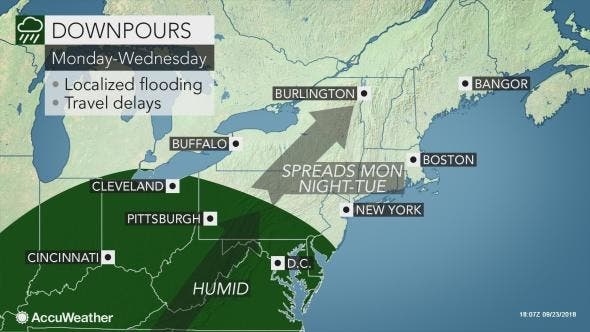
Overall, a cool start to autumn will give way to increasing warmth, humidity and thunderstorms across the Northeast in the coming days, according to AccuWeather. The recent arrival of chilly air will last into Monday.
The rain will spread into New Jersey and New York City Monday night and could hamper the morning commute on Tuesday, according to AccuWeather. Rain will continue to fall throughout the day on Tuesday.
Residents can expect rain to spread into the area during Tuesday morning, with the heaviest rain expected during the late afternoon and evening, according to AccuWeather. More rainfall is set to arrive across the Northeast from Wednesday into Wednesday night as a cold front sweeps across the region.
Temperatures will approach 80 degrees from New York City to Boston and be accompanied by much higher humidity, making it feel even warmer, according to AccuWeather. Showers and thunderstorms will reach late in the afternoon and last into the evening hours.
The combination of warmer air and higher humidity will put temperatures near 90 degrees in New Jersey on Wednesday before showers and thunderstorms roll through the area late in the afternoon and evening, according to AccuWeather.
Here is the forecast:
- Monday: Partly sunny, with a high near 66. East wind 10 to 16 mph.
- Monday night: Rain, mainly after 2am. Low around 61. East wind around 16 mph. Chance of precipitation is 80%. New precipitation amounts between a tenth and quarter of an inch possible.
- Tuesday: Showers and possibly a thunderstorm before 2pm, then showers likely. High near 74. South wind 9 to 14 mph. Chance of precipitation is 80%. New rainfall amounts between a half and three quarters of an inch possible.
- Tuesday night: Showers likely, mainly before 8pm. Cloudy, with a low around 68. South wind 5 to 8 mph. Chance of precipitation is 60%. New precipitation amounts of less than a tenth of an inch possible.
- Wednesday: Showers and thunderstorms likely, mainly after 2pm. Mostly cloudy, with a high near 81. Light south wind becoming southwest 5 to 9 mph in the morning. Chance of precipitation is 60%. New rainfall amounts of less than a tenth of an inch, except higher amounts possible in thunderstorms.
- Wednesday night: Showers and thunderstorms likely before 2am, then a chance of showers. Mostly cloudy, with a low around 61. Chance of precipitation is 60%. New rainfall amounts between a tenth and quarter of an inch, except higher amounts possible in thunderstorms.
- Thursday: Partly sunny, with a high near 71.
- Thursday night: A chance of showers. Mostly cloudy, with a low around 59. Chance of precipitation is 30%.
Tom Davis photo
Get more local news delivered straight to your inbox. Sign up for free Patch newsletters and alerts.


