

Not pleased with the dreary weather from the weekend? Looks like we'll have to wait even longer for the sunshine to arrive.
Forecasters say the dreary, stormy conditions from the weekend are expected to last into Wednesday, making driving conditions difficult. The National Weather Service has issued an alert saying scattered showers and isolated thunderstorms will move through New Jersey Tuesday.
Downpours and occasional cloud-to-ground lightning are the main threats. Rainfall amounts up to a quarter-inch may occur as these showers and storms move through, according to the National Weather Service.
Find out what's happening in Point Pleasantfor free with the latest updates from Patch.
Storms erupting across western Pennsylvania "will pack a punch" in some communities with the risk of torrential downpours, high winds and hail into Tuesday night before moving to eastern Pennsylvania and New Jersey on Wednesday, according to an AccuWeather release.
By the time those storms move into our region, they should have less of an impact.
Find out what's happening in Point Pleasantfor free with the latest updates from Patch.
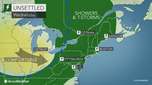
"While a heavy, gusty thunderstorm can occur just about anywhere in the Northeast, the greatest concentration of strong storms will be over Pennsylvania and New York state into Tuesday night," AccuWeather Lead Storm Warning Meteorologist Eddie Walker said in the release.
Where downpours repeat, there will be an elevated risk of flash, urban and small- stream flooding. Winds can be strong enough in some of the storms to down trees, damage power lines and cause minor property damage. Some of the strongest storms can produce hail large enough to damage crops, vehicles and homes, according to AccuWeather.
Here is the forecast:
- Tuesday afternoon: Showers likely, mainly before 3pm. Cloudy, with a high near 63. Southeast wind around 10 mph. Chance of precipitation is 70%. New precipitation amounts of less than a tenth of an inch possible.
- Tuesday night: A chance of showers, mainly before midnight. Cloudy, with a low around 56. Southeast wind 3 to 8 mph. Chance of precipitation is 30%. New precipitation amounts of less than a tenth of an inch possible.
- Wednesday: A slight chance of showers after 1pm. Mostly cloudy, with a high near 75. Calm wind becoming south 5 to 7 mph in the morning. Chance of precipitation is 20%.
- Wednesday night: A chance of showers and thunderstorms. Mostly cloudy, with a low around 59. Southwest wind around 8 mph. Chance of precipitation is 40%. New precipitation amounts between a tenth and quarter of an inch, except higher amounts possible in thunderstorms.
Patch file photo
Get more local news delivered straight to your inbox. Sign up for free Patch newsletters and alerts.


