Crime & Safety
Point Pleasant Roads Flooded After Storm (Video)
Police told people to take necessary precautions. Video shows many roads are flooded.


Police told Point Pleasant Boro and Point Pleasant Beach residents on Tuesday to take necessary precautions since local roads flooded following a storm.
Residents were told to avoid all unnecessary travel as roads throughout Point Pleasant Boro and Beach flooded. Live videos showed Dorsett Dock Road, Bridge Avenue, Route 35 and other roads completely underwater.
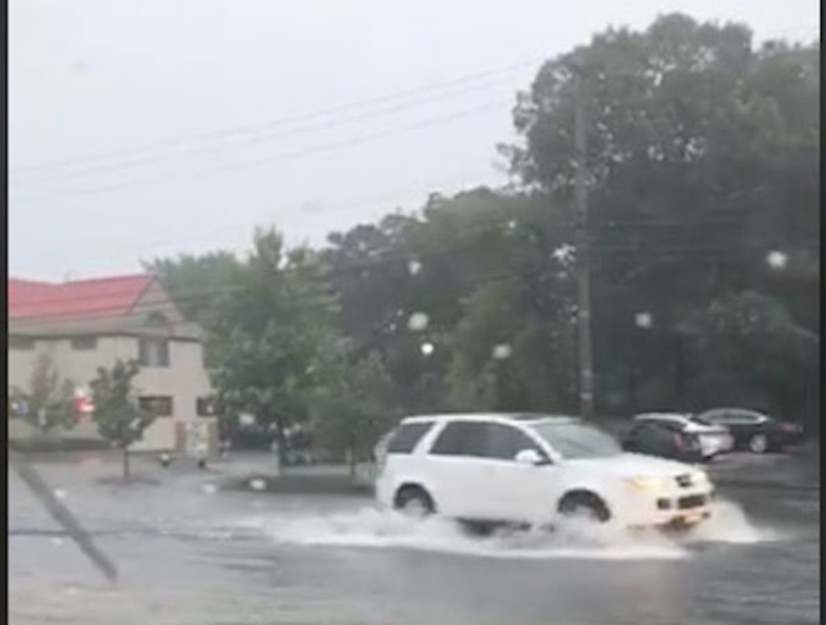
Deanna Jividen of Point Pleasant Boro took a live video that showed flooding in front of Gerards Wine and Spirits on Bridge Avenue (see picture).
Find out what's happening in Point Pleasantfor free with the latest updates from Patch.
Here are other videos:
Severe flooding route 35 point pleasant beach @News12NJ @JGodynick @DaveCurren pic.twitter.com/bFEWwn9X5I
— Jim Murdoch News12NJ (@ReporterJim) July 17, 2018
Find out what's happening in Point Pleasantfor free with the latest updates from Patch.
Don't drive in the point pleasant beach area! Lots of spot flooding now in addition to the lightning @News12NJ @JGodynick @DaveCurren pic.twitter.com/e2klcquOQy
— Jim Murdoch News12NJ (@ReporterJim) July 17, 2018
Route 35 flooded in Point Pleasant Beach @News12NJ @DaveCurren @JGodynick pic.twitter.com/ASKmyx8gkc
— Jim Murdoch News12NJ (@ReporterJim) July 17, 2018
More Point Pleasant Beach flooding at the 88 35 circle @News12NJ @DaveCurren @JGodynick pic.twitter.com/kJ9jQGHWtt
— Jim Murdoch News12NJ (@ReporterJim) July 17, 2018
This is a developing story. We'll have more information as it comes in.
Some of the strongest storms New Jersey has had in weeks have arrived on Tuesday, bringing with them damaging winds that could lead to power outages. More than 10,000 are without power (see list below).
A severe thunderstorm warning was declared for parts of the state, particularly in Central Jersey. There are 60-mph wind gusts and penny size hail. Damage to roofs, siding, trees, and power lines is possible.
The winds were so bad that the Port Newark APM Terminals closed at 3 p.m. There also were reports of flooding (see below).
Parts of Ocean County were underwater. Roads were being closed.
Flight Activity Status #EWR is experiencing delays to some flights due to NY/NJ region thunderstorms: Arrivals: averaging departure origin delays of 5hrs 25mins Departures: averaging 2hrs & increasing Confirm flight status with your airline before going to EWR pic.twitter.com/ihuVfFoz0I
— Newark Liberty Airport (@EWRairport) July 17, 2018
Heavy storms with torrential rain and strong winds are in the forecast, and a flash flood watch has been issued for much of New Jersey starting and going through the evening.
- NEWARK CITY 2,027
- BRICK TOWNSHIP 1,593
- MORRIS PLAINS BOROUGH 1,225
- MORRIS TOWNSHIP 998
- MIDLAND PARK BORO 895
- PARAMUS BORO 473
- BRANCHBURG TOWNSHIP 472
- FAIRVIEW BORO 448
- NEW PROVIDENCE BOROUGH 348
- WEST MILFORD TOWNSHIP 237
- LIBERTY TOWNSHIP 219
- CHATHAM TOWNSHIP 209
- OCEAN TOWNSHIP 162
- FAIRFIELD TWP 141
- PARSIPPANY TROY HILLS TOWNSHIP 135
- WALDWICK BORO 124
- MOUNT OLIVE TOWNSHIP 110
- MORRISTOWN TOWN 109
- MILLSTONE TOWNSHIP 69
- POINT PLEASANT BOROUGH 59
- WEST CALDWELL TWP 17
- MIDDLETOWN TOWNSHIP 16
- MOUNT ARLINGTON BOROUGH 11
- MONTVILLE TOWNSHIP 10
More flooding in Jersey City. So far, we haven’t seen any street closures but some streets are down to one lane. @CBSNewYork pic.twitter.com/NQsTzN3acD
— Marc Liverman (@MarcLiverman) July 17, 2018
Flooding under the approach to the Holland Tunnel in Jersey City. @CBSNewYork pic.twitter.com/BQNmhj7BJQ
— Marc Liverman (@MarcLiverman) July 17, 2018
A hazardous weather outlook has been issued for the entire state, with thunderstorms beginning in the afternoon that could become severe and produce damaging winds.
Here are the alerted areas:
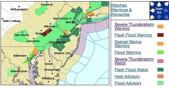
According to the National Weather Service, thunderstorms producing heavy rain could result in flash flooding across along and near the I-95 corridor.
Read more: Watch This Amazing Lightning Strike On NJ Turnpike
Here's what else:
- One to two inches of rain is expected, though three inches or more is possible in some areas.
- The Weather Channel, in its hourly forecast, predicts storms will start about 3 p.m. and could continue through nightfall.
- The heaviest rain is expected this afternoon and evening, including the afternoon commute. Excessive rainfall within a short period of time can lead to rapidly rising water and flash flooding, particularly in urban areas and along small creeks and streams.
- "Rapidly rising flood waters may quickly inundate roadways and areas of poor drainage. Streams and creeks could leave their banks, flooding nearby properties. Please monitor the forecast, especially if you live in a location that is prone to flooding," the NWS said.
- Skies will clear Wednesday, when sunshine and highs in the upper 80s are predicted.
-1531836686-4670.jpg)
Here is the forecast:
Today: Showers and thunderstorms, mainly after 3pm. Some storms could be severe, with damaging winds and heavy rain. High near 89. Southwest wind around 10 mph. Chance of precipitation is 80%. New rainfall amounts between a half and three quarters of an inch possible.
Tonight: Showers and thunderstorms likely before midnight, then a chance of showers between midnight and 1am. Some storms could be severe, with damaging winds and heavy rain. Cloudy, then gradually becoming partly cloudy, with a low around 66. West wind 6 to 10 mph becoming north in the evening. Chance of precipitation is 60%. New precipitation amounts between a half and three quarters of an inch possible.
Wednesday: Sunny, with a high near 87. North wind around 9 mph.
Wednesday Night: Mostly clear, with a low around 60. North wind around 7 mph.
Thursday: Sunny, with a high near 84. North wind around 7 mph.
Thursday Night: Mostly clear, with a low around 62.
Friday: Sunny, with a high near 87.
Friday Night: Partly cloudy, with a low around 66.
Saturday: A chance of showers and thunderstorms. Partly sunny, with a high near 84. Chance of precipitation is 30%.
Saturday Night: A chance of showers and thunderstorms. Mostly cloudy, with a low around 68. Chance of precipitation is 50%.
Sunday: Showers likely and possibly a thunderstorm. Mostly cloudy, with a high near 82. Chance of precipitation is 70%.
Sunday Night: Showers likely and possibly a thunderstorm. Mostly cloudy, with a low around 69. Chance of precipitation is 60%.
Image via YouTube
Get more local news delivered straight to your inbox. Sign up for free Patch newsletters and alerts.