Politics & Government
Report Shows How At Least 19 NJ Towns 'Soon' Could Be Under Water
See how at least 19 New Jersey communities would be impacted by climate change predicted in a United Nations report.

NEW JERSEY — A new United Nations report shows climate change is moving at such a rapid pace that the oceans could rise 3.6 feet by 2100, perhaps plunging as many as 19 New Jersey communities into the water in the process (see maps below).
The expected sea level rise is about 12 percent higher than what was predicted only six years ago, all caused by warming oceans and melting glaciers, according to a report released this week by the Intergovernmental Panel on Climate Change.
The findings came as world leaders gathered this past week at the United Nations for a “climate summit” aimed at injecting new momentum into the effort to persuade countries to do more to move away from fossil fuels and toward cleaner forms of energy, according to The Washington Post.
Find out what's happening in Point Pleasantfor free with the latest updates from Patch.
“The climate emergency is a race we are losing — but it is a race we can win if we change our ways now,” U.N. Secretary General António Guterres said in the report. “Even our language has to adapt: What once was called ‘climate change’ is now truly a ‘climate crisis.’ … We are seeing unprecedented temperatures, unrelenting storms and undeniable science.”
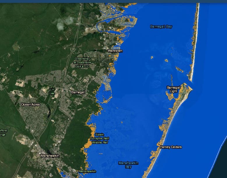
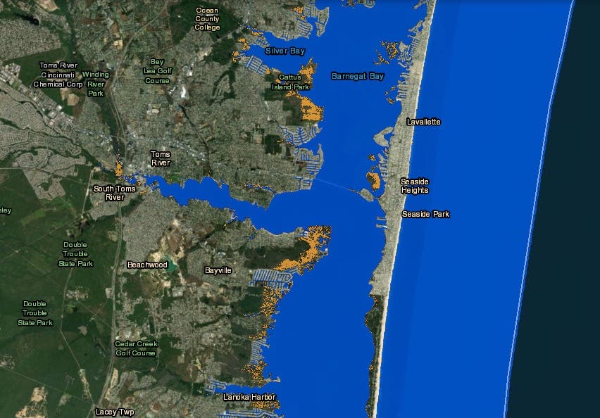
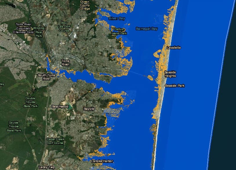
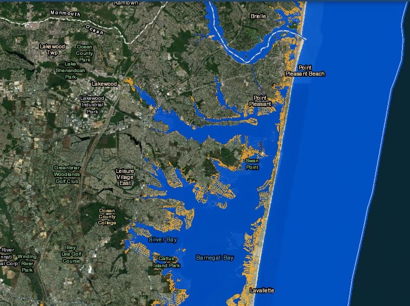
The National Oceanic and Atmospheric Administration released an interactive map showing how Seaside Heights, Seaside Park, Lavallette, Point Pleasant Beach, Bay Head, Long Beach Island, Wildwood, Cape May, North Wildwood, Stone Harbor, Sea Isle City, Avalon, Brigantine and Ocean City could suffer tremendously and could find themselves almost completely under water if the sea level were to rise more than 3 feet.
Find out what's happening in Point Pleasantfor free with the latest updates from Patch.
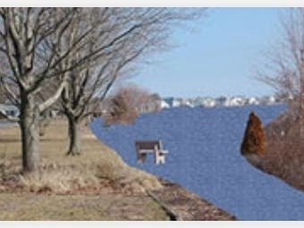
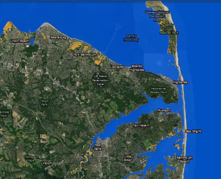
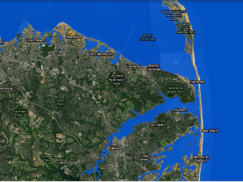
Monmouth County – particularly those areas hurt by Superstorm Sandy – would be hurt, too. One photo showed a park bench literally sitting in the middle of a waterway in Lake Como.
Here is what those areas would look like:
Current:

3.6-foot sea-level rise:

Current:

3.6-foot sea-level rise:

Current:

3.6-foot sea-level rise:

Current:

3.6-foot sea-level rise:

Current:

3.6-foot sea-level rise:
Current:
3.6-foot sea-level rise:
Current:

3.6-foot sea-level rise:
Current:
3.6-foot sea-level rise:
You can read the United Nations report here and click on the interactive NOAA map here.
Get more local news delivered straight to your inbox. Sign up for free Patch newsletters and alerts.


