Weather
Severe NJ Weather, 60-MPH Winds Possible: Here's What To Expect
Bad summer weather is expected. Here's where and when.


Severe weather is possible in New Jersey on Thursday, with forecasters predicting that the state should be dealing with a round of potentially summer storms with potentially damaging 60-mph winds.
The National Weather Service has issued a hazardous weather outlook for most of the state, saying showers and thunderstorms are expected, especially during the late afternoon and early evening.
Rain and thunderstorms are pushing S. Cold front already into NNJ. Check out the sea breeze front moving in off the ocean. Rain and storms should continue pushing S through all of NJ by midnight. Be safe! JC pic.twitter.com/WnbZ5WHtH3
— Weather NJ (@myWeatherNJ) September 12, 2019
Street #flooding at the corner of Pinewald and Beechwood in Burlington Township, @NWS_MountHolly. 0.93” of rain in the @davisinst VantagePro2 as of 17:00. Spotter ID: BTNJ-024 #NJwx pic.twitter.com/5Qyp3TcB3E
— Burlington NJ Wx (@BurlingtonNJWx) September 12, 2019
The NWS also says dangerous rip currents will impact New Jersey beaches through the end of the week.
Find out what's happening in Point Pleasantfor free with the latest updates from Patch.
Here's what also you should expect, according to the NWS:
- The worst weather is expected to be in the Central Jersey to South Jersey areas, farther to the west.
- Mercer, western Middlesex and all South Jersey counties – incuding Ocean – could experience downpours, lightning and thunder, according to the National Weather Service. But other areas could be impacted, too.
- The National Weather Service says the wind gusts could be potentially damaging, which means they could be as strong as 60 mph.
- The worst weather should happen afte 4 p.m.
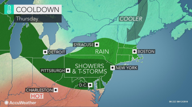
An area of showers and thunderstorms across Pennsylvania and New Jersey will be the dividing line between the cooler air to the north, according to the AccuWeather. High temperatures could still reach the upper 80s on Thursday.
Find out what's happening in Point Pleasantfor free with the latest updates from Patch.
.png)
Here is the forecast:
- Thursday: A chance of showers and thunderstorms, then showers likely and possibly a thunderstorm after 4pm. Patchy fog before 9am. Otherwise, mostly cloudy, with a high near 82. West wind 5 to 8 mph becoming north in the afternoon. Chance of precipitation is 60%. New rainfall amounts between a tenth and quarter of an inch, except higher amounts possible in thunderstorms.
- Thursday night: Showers and thunderstorms likely before 1am, then a slight chance of showers between 1am and 3am. Mostly cloudy, with a low around 59. Northeast wind 10 to 13 mph. Chance of precipitation is 60%. New precipitation amounts between a tenth and quarter of an inch, except higher amounts possible in thunderstorms.
- Friday: Partly sunny, with a high near 70. Northeast wind 11 to 15 mph.
- Friday Night: Mostly cloudy, with a low around 57. East wind 6 to 9 mph.
Get more local news delivered straight to your inbox. Sign up for free Patch newsletters and alerts.