Weather
'Significant' Storm Update For New Jersey
A significant storm could impact New Jersey this week. We have the latest updates.

A significant storm in the central and eastern United States packed with drenching rain, strong winds, some snow and the potential for gusty thunderstorms could impact New Jersey this week.
The storm could arrive Monday night in the New Jersey, and it looks like the state is going to get mostly rain and thunderstorms, according to AccuWeather.
How strong the storm becomes will determine the magnitude of wintry precipitation, wind and thunderstorms, as well as the extent of rain and warmth, according to AccuWeather.
Find out what's happening in Point Pleasantfor free with the latest updates from Patch.
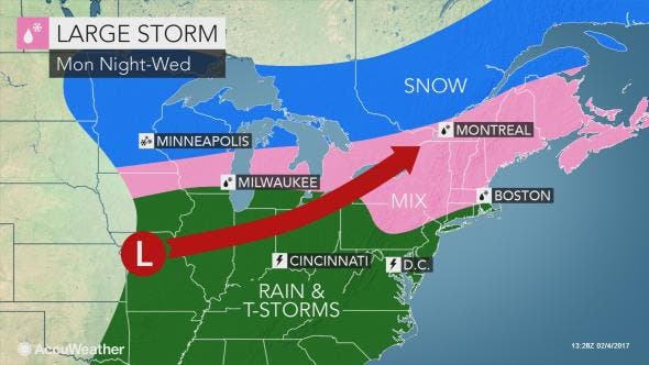
The strength of the storm could be enough to spawn heavy, gusty thunderstorms from the Lower Mississippi Valley to the Tennessee River Valley, with less intense thunderstorms extending as far north as the Ohio Valley and a portion of the New Jersey during the period from Tuesday to Wednesday, according to AccuWeather.
Winds still look gusty Tuesday night in excess of 40 mph at the coast line. Could be enough for localized power outages. pic.twitter.com/A1IZ0nQXxw
— Ed Vallee (@EdValleeWx) February 4, 2017
In the wake of the big storm, cold air will circulate from the northern Plains to much of the Atlantic coast during the second half of the week, according to AccuWeather.
Find out what's happening in Point Pleasantfor free with the latest updates from Patch.
A possible second storm could impact areas from the Appalachians to the Atlantic coast. How much moisture remains as the cold air returns will determine whether or not a period of snow develops, according to AccWeather.
Here are the latest expectations during the Sunday thru Tuesday time frame. https://t.co/ka2HFv1cF3 pic.twitter.com/K652NWcnZV
— NWS Mount Holly (@NWS_MountHolly) February 3, 2017
- Monday: Scattered flurries in areas of northern New Jersey. Cloudy, with a high near 39. Southwest wind around 10 mph.
- Monday night: Partly cloudy, with a low around 24. West wind around 8 mph.
- Monday: Mostly sunny, with a high near 39. Northwest wind around 7 mph becoming west in the afternoon.
- Monday night: A chance of rain, or snow, freezing rain, and sleet, in areas of northern New Jersey before 3 am, then a chance of snow and sleet, or rain between 3am and 4am, then a chance of sleet after 4am. Mostly cloudy, with a low around 28. Calm wind. Chance of precipitation is 40%. Little or no snow and sleet accumulation expected.
- Tuesday: Sleet or rain likely, possibly mixed with freezing rain before 8am, then rain likely, possibly mixed with freezing rain between 8am and 9am, then rain after 9am. High near 47. Calm wind. Chance of precipitation is 100%. Little or no ice accumulation expected. Little or no sleet accumulation expected.
- Tuesday night: Rain likely. Cloudy, with a low around 43. Chance of precipitation is 70%. New precipitation amounts between a tenth and quarter of an inch possible.
- Wednesday: A chance of showers. Partly sunny, with a high near 52. Chance of precipitation is 40%.
Patch file photo
Get more local news delivered straight to your inbox. Sign up for free Patch newsletters and alerts.


