Weather
NJ Weather: 'Strong' Nor'easter Expected: Latest Estimates
The National Weather Service says the storm will be "strong," and alerts have been issued.


A "strong" nor'easter is on track to hit New Jersey beginning late Thursday afternoon, and is expected to produce a lot of rain – and 2 to 5 inches of snow in some areas – over a 36-hour period, according to the National Weather Service.
We have the latest updates (see below). Here is the hour-by hour breakdown for your area. Read more: NJ Weather: Hour-By-Hour Forecast Of 'Major' Nor'easter
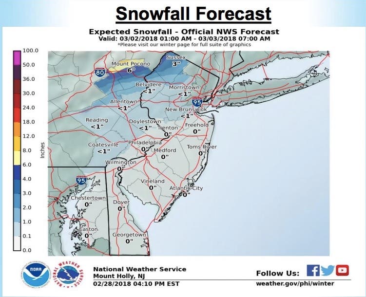
The NWS has issued a hazardous weather outlook for all of New Jersey, saying 1 to 2 inches of rain is expected Thursday afternoon through Friday across the state. Two to 5 inches of snow could fall in Sussex County, and some snow could fall farther south, in Morris County.
Find out what's happening in Point Pleasantfor free with the latest updates from Patch.
Some snow could fall as far south as I-195 in Mercer and Middlesex counties, according to Ray Kruzdlo, a meteorologist with the National Weather Service.
Kruzdlo said the Jersey Shore could get tropical-storm-force winds of up to 50 mph. The storm's rain may result in localized poor drainage and small stream flooding, as well as coastal flooding and beach erosion. South Jersey will get heavy rain.
Find out what's happening in Point Pleasantfor free with the latest updates from Patch.
"It's going to be a strong storm," he said.
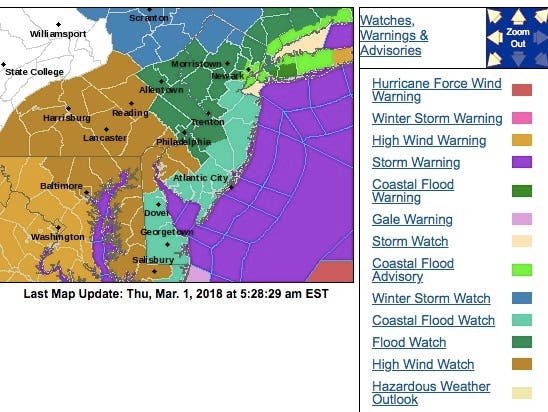
A winter storm watch is in effect in North Jersey. Flood watches and a hazardous weather outlook are in effect elsewhere.
Here are the latest updates:
- This storm is forecast to become a major nor’easter, and all the nasty elements associated with a nor’easter could affect our area into the weekend (strong winds, heavy rain, inland flooding, coastal flooding, and beach erosion).
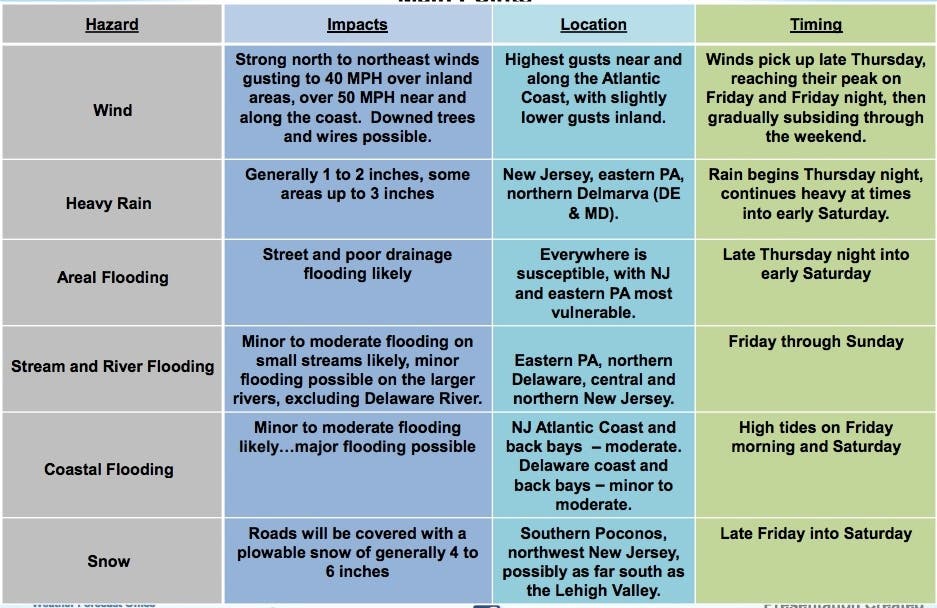
- Precipitation will be moving into the area from the southwest Thursday night, falling heavy at times through Friday before ending early Saturday. 1 to 3 inches expected, with the highest amounts in eastern PA and New Jersey.
- Flooding from ponding on roads and poor drainage areas can be expected with the rain, followed by possible stream and river flooding into the weekend.
- Northerly winds will become strong Thursday night gusting to 20 to 30 mph. Then winds will veer to the northeast later Friday with gusts over 50 mph along the coast, and 30 to 40 MPH inland.
- Rain could change over to snow in the north later Friday with generally 4 to 6 inches of accumulation expected in the Poconos and northwest NJ, 2 inches or so in the Lehigh Valley and central NJ.
- Strong onshore flow and full moon will combine to produce coastal flooding at the times of high tide possibly as early as Friday, but especially on Saturday.
- Waves building to 8 to 12 feet nearshore and 15 to 25 feet over the open water farther offshore from late Thursday through the weekend. Expect rough surf and beach erosion along the coast.
Here are the snowfall estimates:
Here are some of the storm's main points:
The Coast Guard has also issued warnings, encouraging mariners in the mid-Atlantic region to use extreme caution as the major storm system passes through the region.
“Our primary concern is ensuring the safety of mariners,” said Lt. Cmdr. Wes Geyer, command center chief, 5th Coast Guard District. “We encourage all mariners to keep an eye on the weather and avoid putting themselves or their loved ones at risk as the storm passes off the coast.”
Here are a few additional tips to help mariners protect themselves, their families and their vessels:
- Stay up to date on the weather as conditions can change suddenly and with little warning.
- Secure electronic position indicating radio beacons. If unsecured, an EPIRB can break free from a boat and trigger an emergency signal to the Coast Guard.
- Do not go out to sea in a recreational boat when a storm is approaching.
- Contact local marinas to ask for advice about securing a vessel.
- Ensure boating gear is properly stowed or tied down to avoid causing unnecessary searches by the Coast Guard and other first responders. Life jackets, life rafts and small non-powered vessels are some examples of boating equipment often found adrift following severe weather.
One end of the storm will move from the Ohio Valley into New Jersey from the south and west, while a low pressure system will come in and batter the coast, according to the NWS.
AccuWeather says the storm could be the biggest to hit New Jersey since the "bomb cyclone" dumped nearly 10 inches of snow in areas of New Jersey in early January.
As the storm strengthens, winds will increase dramatically over the Midwest and Northeast Thursday night and Friday, according to AccuWeather. Winds are likely to get strong enough to lead to major airline delays from Chicago to Detroit, Pittsburgh, Washington, D.C., Baltimore, Philadelphia, Newark New York City and Boston.
As the storm moves into the Northeastern states, it will get another boost in strength as it reorganizes off the coast of southern New England during Thursday night and Friday. At this point, the storm may become a formidable nor'easter, according to AccuWeather.
While this storm will fall well short of that storm's intensity and will not be as cold, it will still pack a wallop in the Northeast, especially in southern and central New England, according to AccuWeather. Rough surf, beach erosion and coastal flooding is likely to extend from Virginia to Maine from this storm. This graphic depicts the area where the worst conditions are anticipated.
Offshore, seas are expected to build to 20-30 feet with occasionally higher waves. Small craft should remain in port during this storm, according to AccuWeather.
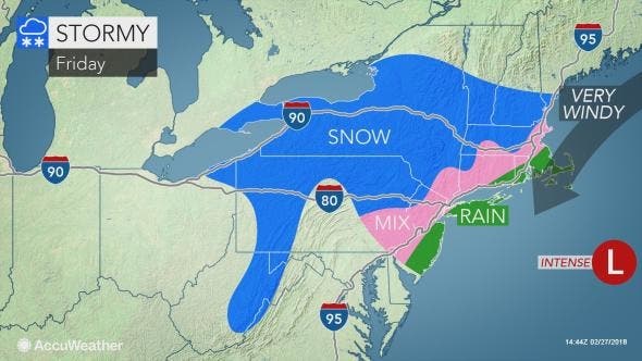
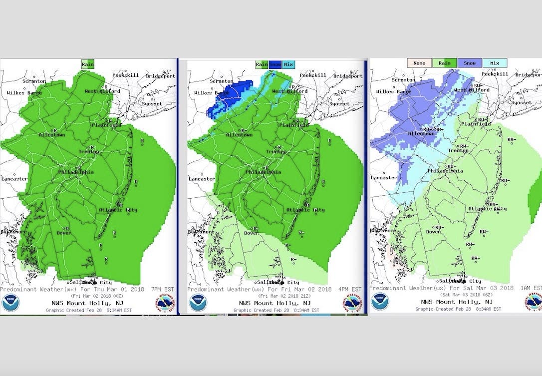
Below is how the storm is supposed to evolve over the 36-hour period – green areas indicate rain; blue is show. The first map is 7 p.m. Thursday; the second is 4 p.m. Friday; and third is 1 a.m. Saturday:
Here is the forecast:
- Wednesday: Partly sunny, with a high near 59. Southwest wind 8 to 10 mph.
- Wednesday night: Mostly cloudy, with a low around 41. Southwest wind 3 to 6 mph.
- Thursday: Rain likely, mainly after 2pm. Mostly cloudy, with a high near 56. Calm wind becoming east 5 to 9 mph in the afternoon. Chance of precipitation is 70%. New precipitation amounts between a tenth and quarter of an inch possible.
- Thursday night: Rain. Low around 40. East wind 9 to 13 mph becoming north after midnight. Chance of precipitation is 90%. New precipitation amounts between three quarters and one inch possible.
- Friday: Rain (some snow in Sussex and perhaps Morris counties). High near 44. Breezy, with a northwest wind 13 to 21 mph, with gusts as high as 34 mph. Chance of precipitation is 90%. New precipitation amounts between a quarter and half of an inch possible.
- Friday night: Rain showers before 4am, then a chance of rain and snow showers. Low around 36. Breezy. Chance of precipitation is 80%. New precipitation amounts between a tenth and quarter of an inch possible.
- Saturday: A chance of rain and snow showers before 8am. Mostly cloudy, with a high near 46. Chance of precipitation is 30%
YouTube video/photo
Get more local news delivered straight to your inbox. Sign up for free Patch newsletters and alerts.


