Crime & Safety
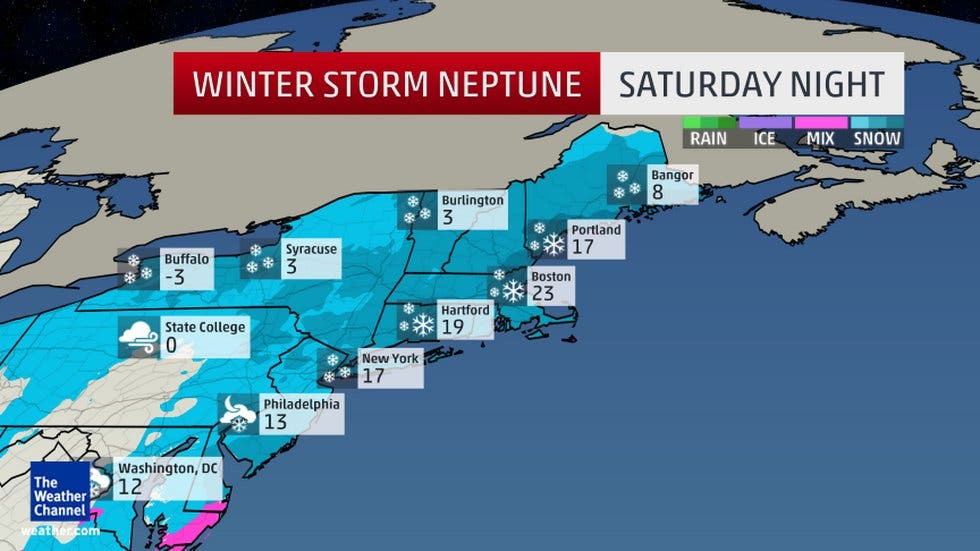
WEATHER UPDATE: 'Damaging' Winds, Snow, Worst Cold Since 2004 Hitting New Jersey
Most New Jerseyans can expect "damaging" tropical-storm-force gusts, causing long power outages. Trees and tree limbs could fall.

Perhaps the weather gods saved the worst for Valentine’s Day and President’s Day weekend.
Nearly all New Jerseyans can expect “damaging” tropical-storm-force gusts, snow and some of the coldest temperatures they’ve had in 11 years beginning Friday, and lasting through the weekend.
The National Weather Service has issued three separate alerts, saying the brutal cold begins Friday, a “damaging” high wind event could occur Saturday and Sunday and at least two to four inches of snow could fall in much of New Jersey on Saturday.
Find out what's happening in Point Pleasantfor free with the latest updates from Patch.
What’s expected, according to the National Weather Service:
- Northwest winds moving at 20 to 30 mph, with gusts up to 60 mph, are coming this weekend. The highest winds should occur late Saturday night, and last into Sunday morning.
- Be prepared for power outages, possibly lasting for more than 24 hours. Trees and tree limbs could be knocked down.
- Minor structural damage to homes is possible. Do not park vehicles where trees can fall on them. Make sure all cell phone and electronic devices are fully charged.
- Two to four inches of snow is expected Saturday afternoon and could last into saturday night. a burst of one to two inches of snow within an hour is possible around dinner time Saturday. The wind will cause some blowing and drifting problems.
- Wind chills will be around 10 below zero on Sunday morning.
>>Related stories:
Find out what's happening in Point Pleasantfor free with the latest updates from Patch.
- WEATHER UPDATE: Hour-By-Hour Forecast Of Snow, Brutal Cold In New Jersey
- WEATHER ALERT: Protecting Your Pipes During New Jersey’s Coldest Weekend In 11 Years
Here are some local predictions for Friday:
Hackettstown (North Jersey) on Friday: Mostly sunny, with a high near 16. Wind chill values as low as -12. Northwest wind 10 to 17 mph. Friday night will be mostly cloudy, with a low around 7. Northwest wind around 5 mph becoming calm in the evening.
Montclair (Northeast New Jersey) on Friday: Sunny and cold, with a high near 14. Wind chill values between -10 and zero. Northwest wind 11 to 15 mph, with gusts as high as 26 mph. Friday night will be mostly cloudy, with a low around 11. Wind chill values between zero and 5. Northwest wind 5 to 7 mph becoming calm in the evening.
Metuchen (Central Jersey) on Friday: Mostly sunny, with a high near 20. Wind chill values as low as -7. Blustery, with a northwest wind 14 to 20 mph. Friday night will be mostly cloudy, with a low around 10. Northwest wind 3 to 8 mph.
Manahawkin (South Jersey) on Friday: Mostly sunny, with a high near 22. Wind chill values as low as -6. Blustery, with a northwest wind 15 to 23 mph. Friday night will be Mostly cloudy, with a low around 12. Northwest wind 5 to 10 mph becoming light west after midnight.
Get more local news delivered straight to your inbox. Sign up for free Patch newsletters and alerts.