Politics & Government
The Lower Hackensack River Is Still A SuperFund Site: Here's The Latest On It
On Monday, the U.S. Environmental Protection Agency gave an update on where the Hackensack River is with its SuperFund status:


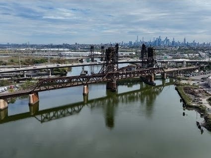
SECAUCUS, NJ — On Monday of this week, Sept. 21, the U.S. Environmental Protection Agency gave an update on where the Hackensack River is with its SuperFund status.
In September 2022, the Lower Hackensack River — meaning the river directly in front of Secaucus — was officially given federal SuperFund status. What SuperFund status means is that federal dollars will be directed to do a clean-up of the river's mud, which has high amounts of chromium and other heavy metals due to years of industry along the river's banks.
Once President Donald Trump began his second term in January of 2023, the fate of the Hackensack remained uncertain, as Trump made deep cuts to EPA funding.
Find out what's happening in Secaucusfor free with the latest updates from Patch.
However, the Hackensack does still remain a SuperFund. Actually, Trump said he wants to fast-track SuperFund clean-ups so Superfund and brownfield sites can be turned into AI data center locations.
Here is the latest as to where the project is as of Sept. 21 from the EPA (and here's the latest from the EPA on this: cumulis.epa.gov/supercpad/cursites/csitinfo.cfm?id=0201845)
Find out what's happening in Secaucusfor free with the latest updates from Patch.
"Starting the week of September 14, 2026, contractors working for the companies potentially responsible for the contamination started studying the river bottom of the Lower Hackensack River Superfund site, under the supervision of the U.S. Environmental Protection Agency.
Workers measured the depth of the river and map out the features of the riverbed. This work covers a 22-mile stretch of the river, starting from where it meets near the mouth of the river in Hudson County and extending up to the Oradell Dam in Bergen County.
During this time, residents in the area around the river may see small boats, up to approximately 25 feet in length, towing survey equipment on the Lower Hackensack River (again, this means right in front of Secaucus). Residents may also see aircraft-like a small fixed-wing airplane, equipped with laser scanning technology that measures elevation along the shoreline. These activities are expected to be completed by the end of October 2026.
During the week of October 5, contractors and the EPA will assess the condition of habitat and vegetation communities, observe shoreline characteristics, and visually inspect outfall locations, bridges, and other structural features in the area located between river mile 2, near the Pulaski Skyway crossing, and river mile 5.5, near the southern end of Laurel Hill Park in Secaucus. During this assessment, community members may see a pontoon boat and workers on the river. EPA anticipates that the assessment activities will be completed by early October 2026.
The information collected as part of these activities will help EPA understand the current conditions throughout the Lower Hackensack River Superfund site. This information will help EPA plan where and how to take future samples and guide the agency in identifying the full scope of the contamination and designing early cleanup plans for this portion of the site.
That clean-up is referred to by the EPA as Phase 2. They have not released any details about what Phase 2 will entail. The federal government moves slowly, especially with SuperFund clean-ups. It remains unknown when the clean-up will begin or how long it will take; the Bergen County Record reported in 2022 it "will likely take years or even decades to complete."
Lower Hackensack River Officially Designated A Superfund Site (Sept. 2022)
Get more local news delivered straight to your inbox. Sign up for free Patch newsletters and alerts.