Weather
2 Chances Of Winter Weather In New Jersey This Week
So maybe this is our last potential threat of snow? There are two chances of it happening in New Jersey this week.


New Jersey has another winter weather threat looming, and it could bring enough snow for shoveling.
Snow, or a wintry mix, is possible later this week after a dramatic upswing in temperatures. Some communities could go from experiencing highs in the 50s and lower 60s to dusting off snow shovels and revving up snowplows, according to an AccuWeather release.
While it is not likely to strengthen into a major winter storm, a system could spread a narrow swath of accumulating snow from the lower Great Lakes to part of New Jersey and Pennsylvania on Thursday and Thursday night.
Find out what's happening in Toms Riverfor free with the latest updates from Patch.
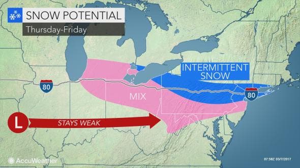
Where the snow falls light enough during the day, it could have difficulty sticking to roads due to the stronger March sun.
A weekend storm may prove to be far more impactful than the late-week system, unleashing a more widespread and significant snow event from the Midwest to New Jersey.
Find out what's happening in Toms Riverfor free with the latest updates from Patch.
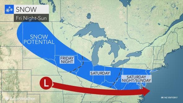
If the storm develops to its full potential, it could unload 6 inches or more of windblown snow.
“The Northeast has had everything from frigid cold this weekend and warm spells early this week but has largely avoided snow recently,” AccuWeather Chief Meteorologist Elliot Abrams said.
“But late this week, a storm will sneak in from the west, and it could bring snow,” Abrams said.
Heavy rain along the southern fringe of the snow and severe weather in the South may round out the potency of this storm. On the heels of this system, another one or two snowstorms may follow next week.
- Tuesday: A chance of showers. Cloudy, with a high near 58. South wind 6 to 8 mph. Chance of precipitation is 50%. New precipitation amounts of less than a tenth of an inch possible.
- Tuesday night: Showers, mainly before 4am. Low around 49. South wind around 11 mph. Chance of precipitation is 80%. New precipitation amounts between a quarter and half of an inch possible.
- Wednesday: A chance of showers before 7am, then a slight chance of rain between 7am and 9am. Mostly cloudy, then gradually becoming sunny, with a high near 61. West wind 8 to 18 mph, with gusts as high as 29 mph. Chance of precipitation is 30%. New precipitation amounts of less than a tenth of an inch possible.
- Wednesday night: Mostly clear, with a low around 40. West wind 11 to 13 mph.
- Thursday: Sunny, with a high near 53. West wind 11 to 18 mph, with gusts as high as 29 mph.
- Thursday night: A chance of rain before 1am, then a chance of rain and snow between 1am and 4am, then a chance of snow after 4am. Mostly cloudy, with a low around 33. Chance of precipitation is 50%. New precipitation amounts of less than a tenth of an inch possible.
- Friday: A chance of snow before 3pm. Mostly cloudy, with a high near 42. Chance of precipitation is 40%.
- Friday night: Partly cloudy, with a low around 22.
- Saturday: Mostly sunny, with a high near 33.
- Saturday night: Mostly cloudy, with a low around 23.
- Sunday: A chance of snow. Mostly cloudy, with a high near 34. Chance of precipitation is 30%.
Patch file photo
Get more local news delivered straight to your inbox. Sign up for free Patch newsletters and alerts.


