Weather
New Jersey Weather: Big Changes This Week
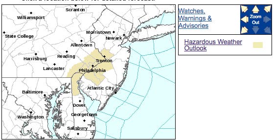
A hazardous weather outlook was issued, but not for the kind of weather you'd expect.

What a difference in just one week: We're going to go from cold rain to record heat in New Jersey, forecasters say.
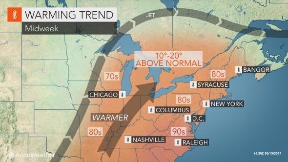
Sunshine and 90-degree heat will overtake the region by the middle of this week. By Wednesday afternoon, people from the Mid-Atlantic to New England will be basking in the warmth, according to AccuWeather.
It's supposed to get so hot that the National Weather Service has issued a hazardous weather outlook for parts of southern New Jersey, saying a "heat episode" is anticipated Wednesday and Thursday for the urban corridor from Wilmington to Philadelphia to Trenton.
Find out what's happening in Toms Riverfor free with the latest updates from Patch.
Temperatures will climb well into the 80s as far north as northern Maine, while New Jersey and Pennsylvania will approach 90 degrees on one or more days this week, according to AccuWeather.
Just don't be ready to jump in a lake or in the Atlantic Ocean: Ocean water temperatures are still dangerously low this time of the year and range from the 40s along much of the New England coastline to the 50s along much of the New Jersey coastline.
Find out what's happening in Toms Riverfor free with the latest updates from Patch.
But it looks like the real spring, pre-summer weather is finally coming.
"Manhattan, New York, had a high of 87 on April 16, but the warmth was a only a false start," AccuWeather Chief Meteorologist Elliot Abrams said in a release. "This week, temperatures are likely to surpass the 87-degree mark, which was the highest temperature of the year so far."
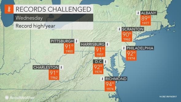
Cities such as Philadelphia, Baltimore, Washington, D.C., Charleston, West Virginia, and Richmond, Virginia will reach or exceed 90. At this level, daily record highs will be challenged on one or more days. Some records that could fall date back to the early 1900s
Temperatures along some of the south-facing beaches will be 10 to 15 degrees lower than areas along much of the Interstate 95 corridor.
The summer-like pattern in store for much of this week will not mark a long-lasting end to cool conditions for the month, according to AccuWeather
"Cooler air will settle back across the region this weekend and into early next week," Abrams said.
However, temperatures are not likely to dip as low as they dropped the past couple of weekends. In most areas, highs will only be trimmed back to the 60s and 70s.
Here is the NWS forecast:
- Tuesday: Sunny, with a high near 79. West wind 7 to 9 mph.
- Tuesday night: Partly cloudy, with a low around 56. Southwest wind 5 to 7 mph becoming calm in the evening.
- Wednesday: Sunny, with a high near 91. West wind 6 to 11 mph.
- Wednesday night: Partly cloudy, with a low around 67. South wind around 8 mph.
- Thursday: Mostly sunny, with a high near 93. Southwest wind 9 to 13 mph.
- Thursday night: Partly cloudy, with a low around 69.
- Friday: A chance of showers and thunderstorms after 2pm. Mostly sunny, with a high near 89. Chance of precipitation is 30%.
- Friday night: A chance of showers and thunderstorms before 8pm. Mostly cloudy, with a low around 59. Chance of precipitation is 30%.
Patch file photo
Get more local news delivered straight to your inbox. Sign up for free Patch newsletters and alerts.


