Weather
Hurricane Jose Forecast Cone Now Includes New Jersey
Jose's latest forecast track puts New Jersey in its "cone of uncertainty" for the first time. We'll let you know what that means.


The likelihood of impacts in New Jersey from Tropical Storm Jose, which is expected to become a hurricane, continues to rise as the storm's so-called "cone of uncertainty" now includes the Garden State for the first time.
As of 5 a.m. Friday, Jose was churning about 360 miles northeast of the Bahamas. Jose is currently classified as a tropical storm with winds of 70 mph, but it's "showing signs of becoming better organized" and will likely regain hurricane status later Friday, the National Hurricane Center says.
A couple of days ago, Jose was viewed as a minimal threat to New Jersey and expected to head well out to sea, but forecast models have continued to shift the storm's track closer to the East Coast.
Find out what's happening in Toms Riverfor free with the latest updates from Patch.
"We just need to watch it," said Joe Miketta, NWS meteorologist. "The models have bringing it closer to the west. That's one of the reasons why we're taking about the probabilities going up. Anything can happen between now and next week."

With New Jersey now in the storm's forecast cone (historical data indicates that the entire five-day path of the center of a tropical cyclone will remain within the cone about 60-70 percent of the time), the odds of direct impacts from Jose are rising.
Find out what's happening in Toms Riverfor free with the latest updates from Patch.
There's now a 20 percent chance of tropical storm-force winds, meaning 39 mph or more, in coastal New Jersey, but that could change, according to the National Weather Service. The "earliest reasonable arrival time" of tropical storm-force winds in New Jersey is around 8 p.m. Monday.

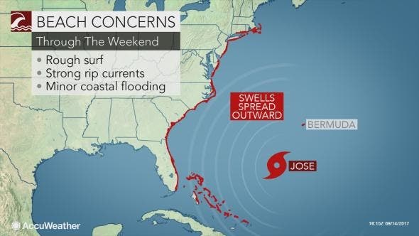
Rough surf will persist in New Jersey into next week. Miketta said, "There is a system in the ocean, so people should be aware that its already having an impact."
According to a hazardous weather outlook issued for the region, "Jose will pose an increasing threat for high surf, dune erosion, localized washovers and dangerous rip currents along the ocean beachfront this weekend through early next week."
Miketta said the Mid-Atlantic states need to keep an eye on what happens because it's still a little too early to predict the path of the storm.
"Interests along U.S. East Coast from North Carolina northward to New England should monitor the progress of Jose during the next several days," the hurricane center says.
With Jose's track continuing to shift ever so slightly west, it's becoming one to watch for the east coast. pic.twitter.com/MHty4wscuY
— Taylor Trogdon (@TTrogdon) September 15, 2017
A heads up: New tracks have Jose closer to our coast next Tuesday. Rain likely. Rough surf at Shore. 7day on @6abc. pic.twitter.com/jBjkGS7Ab5
— davidmurphy6abc (@davidmurphy6abc) September 15, 2017
[Important Message For Mariners] Significant impact likely for Mariners during the early to middle portion of next week from Jose. pic.twitter.com/7ZivI0aOHw
— NWS Boston (@NWSBoston) September 15, 2017
Photo: A beachgoer walks along the water as waves crash in Manasquan, N.J., Thursday, Sept. 14, 2017. Swells are up from recent hurricanes in the Atlantic Ocean, including Tropical Storm Jose, which could impact New Jersey, according to meteorologists. (AP Photo/Julio Cortez)
Get more local news delivered straight to your inbox. Sign up for free Patch newsletters and alerts.


